Showing posts with label Spiral Tunnels. Show all posts

03 May 2024

Calgary, Spiral Tunnels & West, Postcards x6 +1


This image of the CPR Calgary station is probably the oldest of the group. 

Its serial number suggests a 1912 date of publication.  

The camera is facing timetable east.

These cards were purchased during my most recent 'postcard show' sortie.


* * *

The Spiral Tunnels provided many different vantage points for photographers.

Photographers provided many different souvenir images for train travellers to purchase over the years ...


Notice the old-style fishplate which places the rail joint between the ties.


The date stamps probably indicate the 'date of acquisition' for a previous owner.


*  *  *


For your geographical convenience, a map from 1905 is provided below.

You'll need to scroll to the right to see the Laggan (Lake Louise) to Field section - but I thought you'd like to have the whole map - it's a favourite of mine. 

A good graphic artist could get a lot of detail into an image 120 years ago!


from: Annotated Time Table, Eastbound Edition; corrected to July 1905; Canadian Pacific Railway.

This map pre-dates the Spiral Tunnels, but please feel free to draw them in if you wish.


On the map, if you locate Field, Otter Tail and Leanchoil ... Chancellor Peak is east of Leanchoil (near Mount Vaux).


*  *  *

This time, the 'wild card' provides its own map.

Should there be an unfortunate ... well, war ... neutral Sweden looks forward to your visit and your business.


*  *  *

The obligatory wild card map comes from my favourite atlas. 

... So many changes since then ...

So, take me back to Constantinople
No, you can't go back to Constantinople
Been a long time gone, Constantinople
Why did Constantinople get the works?


from: see corners for reference, from circa 1900.


26 November 2021

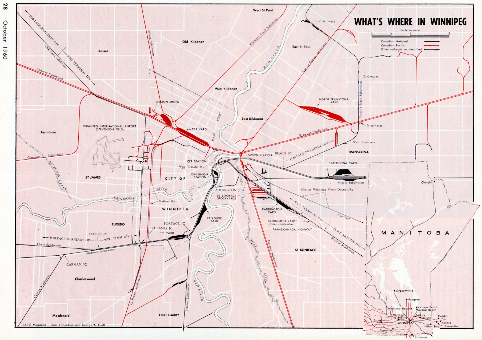
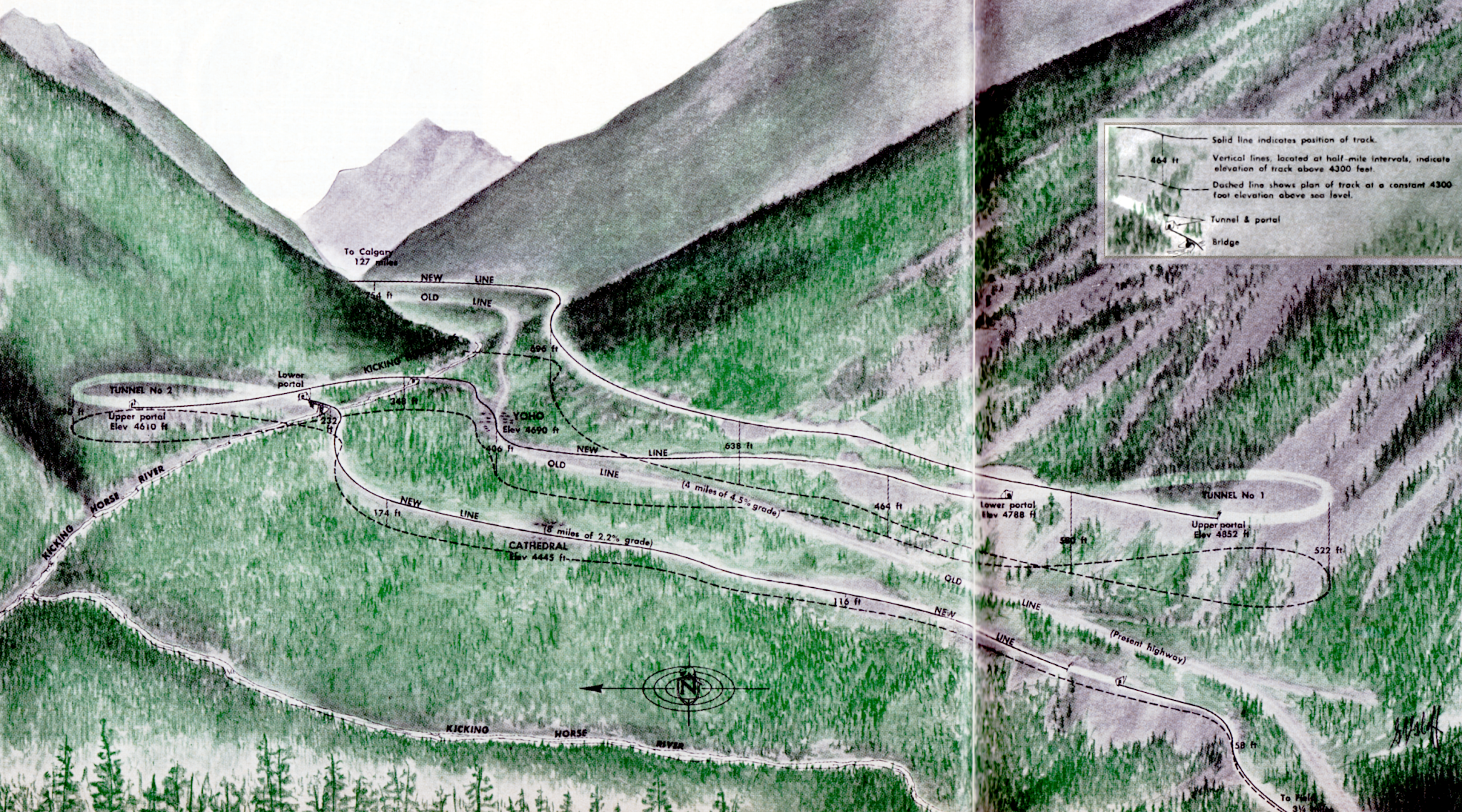
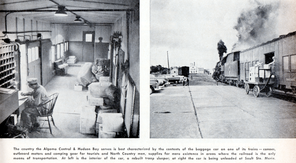
Winnipeg map 1960, Spiral Tunnels diagram, ACR Baggage Car interior, CNR 86


Trains supplies two important historical hand-drawn images and an interesting car interior photo.


from: Trains and Travel, Railroad and Photo Annual, 1953


While 3/4 front views of locomotives are nice, interior rolling stock photographs are dandy for depicting the human experience of railroading and rail travel.

Photos by AC Kalmbach, himself, from: Trains and Travel, Railroad and Photo Annual, 1953


Somewhere I read that a surprising number of light steam locomotives operated from the beginning of the CNR (they generally originated from the CNR's predecessor railways) until near the end of steam in 1960. 

... Of course, these light locomotives would have been rebuilt a number of times. They continued in service because they were ideally suited to light-rail branch lines which had never been upgraded with heavier rail (or in some cases with significant crushed rock ballast, or tie plates) since their construction. 

Eventually, these branch lines died because of: the loss of freight and express business to trucking firms running on 'new free paved highways'; the end of Royal Mail contracts which had subsidized local passenger trains; or the growth of diesel locomotive rosters (including Budd cars) which allowed more efficient and economical servicing of the branch lines with diesel power.

After its appearance on the Westport Subdivision, which was abandoned in 1952 ...


The 86 was photographed by Don Wood heading south from Owen Sound as seen in August 1958 Trains.


05 September 2020

CPR 1909 No Frickin' Laser Beams!


" [The Spiral Tunnels] were the largest tunnelling feat undertaken in Canada at the time, and were a remarkable achievement for the days before laser transits and sophisticated surveying techniques. "

The Spiral Tunnels and the Big Hill; Graeme Pole; 1995; Altitude Publishing Canada.


A friend mentioned that some people on the internet had recently contemplated the complexity of the construction work for the Spiral Tunnels. The fact that the tunnels were built with a precise curving route and with a precise gradient - without access to GPS and modern electronic surveying equipment - evokes awe and sparks curiosity to find out what methods were available to the civil engineers and surveyors over a century ago.


from: Beautiful BC magazine, summer 1985.

The headend cars of a passenger train, make their way up the Big Hill in this undated photo.


The photo from the Mount Royal Tunnel book (below) came to mind and I started digging through my textbooks from that era to see if I could connect the activity shown there with some text to explain it. 


from: The Mount Royal Tunnel; Tony & Eric Clegg; 2008; Railfare DC Books.

I think the spider is in the foreground, putting out its line.


How I came to understand some of this engineering and surveying information ...

If the stars (and sun) are considered to be pinholes in a black ball which encases the earth ... and you can determine 'straight above us' as the position where the sun casts no shadow at 'solar noon' ... then, with accurate chronometers to measure time ... and accurate optical instruments to measure angles ... and math ... you can probably figure out what the inside of the ball should look like at any other time. 

Naturally, we have seasons where the sun and black ball appear to shift ... but, trust me, you don't want to read more of my half-baked musings that you have to ...

So, in the olde, olde days, if it was solar noon at the Royal Observatory at Greenwich, England maybe you'd line up a telescope tube with the crosshairs at the sun's centre. Don't try this at home! 

Having nailed 'exactly overhead' ... you'd use other telescope tubes with crosshairs ... and a protractor ... to start to work out a list of angles for important stars and the sun at various times of the 24 hour day for 365 days. 

... Great! If your watch breaks in Greenwich, you can now use an optical instrument, a table of values and math to figure out what time it is.

MAYBE ... if you want to make a buck ... you can sell a copy of a 'clever but boring math-heavy book of angles and times' to a sailor. First, though, you'd have to calculate and provide many more values for a range of positions across the face of the globe. 

Olde Sailor says what? : I, 'Olde Sailor', set my accurate clock at 'noon' when I was last in London towne. Look up yonder ... there are some stars I recognize up above. My chronometer says exactly 6 PM Greenwich time. I'll calculate the 'angles' of those stars. Using the book and some mathematics, I'll calculate where I'd be at "6 PM Greenwich" ... "this star at this angle", "this star at that angle".

Curiosity, commerce and war inspired people, over time, to develop increasingly accurate tables of figures which ... out on the ocean, out in the field, or flying commercial aircraft in the 1950s ... enabled other people possessing accurate optical instruments and chronometers to figure out exactly where they were on the globe.

... And so that's how they built the Spiral Tunnels! 


It's not much more complicated than that.


* * *

Think about it ... you're standing at the Big Hill where they want the Spiral Tunnels put. 

Your DNA managed to make it across the ocean from Greenwich to Montreal without getting lost and drowning in the dark, wide Atlantic Ocean.

Some explorer/engineer wandered across Canada (maybe even without the help of First Nations guides, for once) and wrote down how to get back from where they had wandered. They produced "a map".

Someone else used that map to decide where to lay down a twin path of metal rails which don't rise more than 2.2 per cent at any point for thousands of miles.

Someone noticed that a United States map showed railways which were pretty close to 'the border' !! 

This 'border thing' was somehow hacked out in a line across the wilderness without Global Positioning System satellites.

So someone made the 'business/political decision' to locate this railway line close to the US border. 

Working on a limited budget, someone decided that it might be necessarily cost-efficient to run the railway down (up for eastbounds) a suicidal 4.5% grade ... for 23 years and 2 months in all ... until you finish drilling and blasting a couple of nice spirally holes in a couple of mountains.

... And now you stand at 'The Big Hill' in September 1907, as work is set to begin ...

You 'got here by train' but consider all the careful celestial sightings, and angles precisely recorded, and distances accurately measured, and persnickety math done by so many people over so many years to get your Greenwich DNA to precisely this location in the mountains.

*   *   *

I once asked a kind, patient, unpaid 'career consultant' at Canada Trust which course was superior for my future training needs: the Canadian Securities Institute Professional Financial Planning course, or the more 'famous' course offered by the Canadian Institute of Financial Planning. 

I shall always remember the friendly eloquence of his answer as he shook his head, smiled and said:

It's all the same s[tuff] !

*  *  *

Dear readers, if you can imagine that people used precision optical instruments, 
measured angles, recorded distances and specialized powerful math 
to get someone's DNA from Greenwich to the Big Hill ...

You will have a 'feel' for the ideas within the textbooks below, because ...

It's all the same s[tuff] !

*  *  *

In most cases, I'll provide the title page of the textbook first, as there is often interesting information printed there. I did not cut off neighbouring sections or paragraphs in all cases, as I thought you might find them interesting.


A transit is that surveying instrument you are most familiar with.
It measures vertical and horizontal angles.


While it may be perfectly acceptable for a surveyor to put most of their stakes dead-centre where a railway line is to be built on the bald prairie, knowing that the railway will be built right over them ...

When you start at an intensive working like a spiral tunnel, everyone and his horse will be trampling down your carefully-located surveying stakes as they travel to and from the face of the excavation.

So you should survey and precisely mark a set of 'stations' which will not be disturbed ... and then use them to calculate and mark where the advancing tunnel work should take place at regular intervals. 

See the illustration for the text above, just below ...


To some extent, this is the principle behind that interesting image from the Mount Royal Tunnel work. 

On a map of Montreal Island: 'X' marks the spot of the sod-turning in the City of Montreal ... but one way to be certain that the two working faces of the excavations will meet at the right spot ... is to accurately calculate point-to-point-to-point-to-point... all the way around the mountain. Do this along the sidewalks in the air and light, until you have measured and angle-calculated exactly where the 'Y' ceremonial sod-turning would take place at the planned Town of Mount Royal at the other end of the tunnel.

If you gave someone your traverse details to site 'Y' as they stood at site 'Y' ... and removed any physical clues from the sidewalks etc ... they should be able to measure and angle their way right back to site 'X' where the sod-turning took place.

Once the bores develop into tunnels, the next job would be to maintain their straightness toward each other as the work progressed. 

It is hard to imagine how many times experienced engineers and surveyors would check their calculations for a high-profile and expensive project like the Mount Royal Tunnel.

*  *  *

While tunneling may be a specialized aspect of CPR main line railroading history, it is nothing new for the profession of engineering, particularly if one considers the historical intertwining of coal and rails ...

Coal Mining in Cape Breton

... how many dark holes had been successfully surveyed before the Spiral Tunnels?


*  *  *

Here is a some elaboration on traverses ...

(see the Mount Royal Tunnel photo)


When you see someone using a transit for surveying ...
you often see another worker holding a stadia rod ...

Easier than shouting:
The transit operator uses hand signals to guide
the positioning of the stadia rod.

As the stadia rod is a standard-sized, precisely-calibrated target ...
it is used for a variety of measuring operations. 


How to survey in the dark, 
and how to protect your stations from everyone and his horse ...


How to run a traverse for railway tunnels.

Tunnels "often several miles in length ... not uniform in either slope or direction".


*  *  *

A book which pre-dates the Spiral Tunnels, 
which were built from September 1907 to May 1909.


from: Yonder Comes the Train; Lance Phillips; 1965; AS Barnes & Co.

The Tehachapi Loop in 1876.


*  *  *


from: Western Rail Trail; Norman McKillop; 1962; Nelson & Sons.


Above: The view from the Monarch Mine in 1919.

While the Spiral Tunnels always seem to be 'up in the mountains',
as this photo shows well, they were constructed down in the valley.


21 September 2016

CPR 1984 Lake Louise to Field


On Friday, June 1 1984 we boarded VIA Train Number 1 - after a stay at Chateau Lake Louise - and continued on a trip west to Vancouver. 

Using a car we rented at Lake Louise, we had spent a day or so travelling between there and Field - following trains as we could. During the few days we had at Lake Louise, we also enjoyed some of the many other attractions of the area. But this post is centred on a few photos I took on the way to Field.

from: CPR Annotated Time Table, Eastbound Edition, corrected to July 7th 1905.
While I have Canadian government topographic maps of the area and various other CPR tourist maps ... this rough effort on cheap paper from over 110 years ago does the nicest job of showing the details. 

You can see the Great Divide marked - from that point the water flows either to Hudson Bay or the Pacific. Lake Louise and the other 'lakes in the clouds' are shown nicely. This was before the highways arrived and the settlement patterns became more complex. 

During the era of the Big Hill, specialized mountain crews operated between the two locomotive terminals at Laggan and Field. After the Spiral Tunnels were in service in 1909, Laggan was no longer required as a terminal and the location was renamed for the nearby lake.


Unused postcard, no date.
Above, the old postcard provides a nice overview of the arrangement of the Spiral Tunnels. 


Below, a circa 1960 CPR descriptive pamphlet provides detail and data on the twenty miles we will travel.

Looking back in history, one would be hard-pressed to think of another
similar short segment of Canadian track or roadway which has received so much attention.

from pamphlet: Westward Across Canada by Canadian Pacific, circa 1960.

*  *  *

June 1, 1984


Lake Louise, looking timetable west.
Notice that that the original telegraph wires entered the rear of the station - as they generally did.


Our train will be following the original track alignment. Behind is a slightly longer, more 'gently' ascending track which will rejoin our route as we reach the summit at the Great Divide. While heavy freights hauling commodities to the Pacific benefit from the newer route, our train will have little trouble running up the steeper grade to the Divide. 


These photos are in chronological order - I checked the negatives. As soon as we could heave our bags into our opposite roomettes and slam the doors, we ran up to the 'cupola'. The dome was often staked out by people well in advance of the departure from Calgary. This dome community was generally thinned out by the time the train neared the Selkirks. 


Here you can see the lower Spiral Tunnel. 

After years of deferred maintenance on the rolling stock it took off CPR's and CNR's hands, VIA was only given 'life support' funding for its operations, and a lot of things were in poor repair. On one trip, our electrical system failed and our sleeping car was 'trainlined' with the adjacent car to the first point of repair at Winnipeg - we had minimal lighting. On another occasion, they had to shut our room's water off because we had a 'doomsday' toilet valve which would have quickly emptied the car's tank ... we were visited by carmen with plumbing skills in our own bedroom at Winnipeg.

On another trip, there was no steam heat through the night north of Superior. Clearly Rolly wasn't running that night. As a former steam fireman, firing up a steam generator probably enabled him to re-live the days of steam power. He took pride in his tale of the night that a VIA 'train rider steam technician' (yes, they had them - that's how bad things had become) couldn't satisfy the need for heat and Rolly went back and got the appliance generating to specifications.

... As bad-ordered VIA equipment relates to this trip: On the ex-CPR domes, the expensive custom Plexiglas front and rear corner dome windows had become very scratched - sometimes to the point of being opaque for photographs. The smaller front centre window (which carmen could open) had double panes of regular glass and you could get a reasonable shot through it. Westbound passenger trains were usually sent through a car washer, with a stop for manual brushing/scratching of dome windows, as Number 1 departed Calgary.

I have tuned these photos up as much as possible. Having photographed in the domes before, I was using an 80-200 mm zoom and fast film. You can often see light-coloured reflections in the glass in these shots.


Unused postcard, no date.

Here is an eastbound freight on an undated postcard.
Notice the fire damage. Back then, fires were often started by the sparks from steel brake shoes.


Detail from unused postcard.
I was curious about the consist.


Here is the valley (mud flats) of the Kicking Horse as it approaches Field.
The Trans-Canada Highway is the through road which you see.

Unused postcard, no date.
Here is a similar view of the Kicking Horse Valley.
This is a terrible image - and what was 'airbrushed' away in the left foreground?
But notice the water tank between the power and the valley.


I assume we are rolling by Yoho here.


By rail or road, this is always an interesting location for telephoto shots.

You can imagine trains of the 'Big Hill' era coming down something like the gradient of that road.


The eastbound freight is clear in the hole for us with its headlight extinguished.


I can hear Rolly saying it: "Straight Approach!"
Our power has not yet knocked down the light at the east switch, Field.

Officially, back then, this was known as an approach signal ...
but the 'straight' underlines with glee the idea that we are lined on a non-diverging route.

*  *  *

I tried to select a couple of passenger timetables with the most interesting details.

from: CPR public time table; August 15, 1936.
This late-Great Depression timetable shows three trains operating. While most working people were probably not doing well, the CPR still advertised its hotels and the nearby 'dude ranches' - someone, somewhere, still had money to spend. The 300-series 'motor trains' are interesting - Regina to Moose Jaw.  ... And 'meal stations' - mainly for people riding in the coach and colonist cars, perhaps.

*  *  *

from: CPR public time table; April 30, 1967 to October 28, 1967.
Don't blink, or you'll miss the short run of CP's Expo Limited. Both railways ran extra trains to accommodate people wanting to visit Expo 67 in Montreal (and/or to see Canada by train as a personal 'Centennial Project') ... during Canada's Centennial of Confederation. There are some nice photos and summaries of the mainly standard equipment used on this train which you can find on the internet.