Showing posts with label postcard. Show all posts

09 May 2026

LCG 1948 Quebec City, Postcards, Maps & The Gnawing Golden Dog


In 1948 LC Gagnon was using his CPR employee pass to take a few vacation days in Quebec City, staying at the Chateau Frontenac. 

He mailed a folder of postcards back home to his sister.  


I think the top postcard shows a CP steamship heading upriver.

After the first simple wooden palisades, the first phase of Quebec's stone wall defences was built between 1745 and 1759 by the French. They were handy, but not decisive after the Battle of the Plains of Abraham. 

Between 1820 and 1832, the British were encouraged by the War of 1812 to further reinforce the city's wall system. This was also the period during which the Citadel was completed.

Between 1871 and 1881, with the British army gone, local residents began to tear the deteriorating walls down - presumably for their stone. Lord Durham, formerly the Governor General, stepped in to save the almost 5 kilometres of walls. This gate was one of those rebuilt in an ornamental style during that preservation process. 

*  *  *


Looking downriver, we see a couple of ferries, simmering at their docks.


from: Tourist Map of Quebec; undated, circa 1948; Quebec Municipal Tourist Bureau.

This map from the 1948 trip shows the whole wall system nicely. The wall articulates with the Citadel at the left. 

The St Louis Gate can be seen at the wall's '11 o'clock' position. The switch for the double-track section of streetcar track in the postcard matches the track arrangement shown on the map.

*  *  *


Looking downriver from the Citadel, the buildings left and centre can be seen today on Google Maps.

*  *  *

Le Chien d'Or

Last artifact from LC Gagnon's 1948 trip shown in this post.

As World War 2 had been keeping everyone busy, there was little time in the age of coal-burning to clean the stonework of the Quebec City main post office building. Doing his best with his box camera, LC Gagnon photographed the building to document the little figure of a dog over the main entrance. 

A house built in 1688 was demolished to make way for this new building. The actual stone from that house, bearing the image and inscription behind various urban legends, was preserved and included in the new structure.


On our current Google Maps view of the former main post office building, we can see they've restored the dog's goldness.


from: BANQ, postcard image.


from: Le Chien d'Or - A Legend of Old Quebec; William Kirby; 1877; Lovell. archive.org

I'm not going to link to the book as there are more Chien d'Or at archive.org than you can throw a Frisbee to.

William Kirby (1817-1906) was born in Yorkshire and ended up at Niagara-on-the Lake. He was variously a tanner, a school teacher and a newspaper editor. He saw the house mentioned above (built in 1688) 4 years before it was demolished to make way for the main post office building in 1869. He was fascinated by aspects of Quebec City during his visit there. He reportedly first read about the Chien d'Or semi-urban-legend in James MacPherson Lemoine's (1825-1912) Maple Leaves book of Canadian lore (first published: 1865).

Kirby's completed novel was shopped around unsuccessfully until it was finally published by Lovell in 1877. As the publisher failed to register the work, it immediately became public domain. 

The Villain of New France

Decades ago, in my English-language school in Montreal, in Grade 5 ... we learned that Francois Bigot (1703-1778) ... the Intendent of New France, beginning in 1748 ... was a corrupt colonial administrator who used his office to make large amounts of money at the expense of the colonists he was supposed to be serving. His preference would have been a comfortable administrative post in a French port but they sent him to Canada instead.

Bigot's negligence facilitated the loss of France's colonies in Canada. We all do well to remember that France's forsaking of these colonies in favour of keeping warmer ones was also a major factor in their change of ownership.

One of the Two Legends ( ... life is too short for both ... )

The virtuous merchant Nicolas Philibert, owner of the house, must have clashed with the corrupt Bigot - perhaps inspiring the installation of the Chien d'Or stone in 1736. In 1748, he was killed during a quarrel with a soldier over a billeting arrangement. Was it a quarrel or a conspiracy? What really happened to his killer? Did the latter finally meet his fate in India? Who saw to the killer's fate?

It would be great to know the true historical facts. However, this is a legend - a tale which people told, altered, and re-told ... before modern, labour-saving inventions like social media.

Writing a Novel

So our friend Kirby took two tragic urban legends of New France and wove them into the contemporary theme of Bigot's real-life corruption. Bigot ... and the words Kirby has him speak ... is actually the book's main character. 

CanLit or History?

The historical motivation for the real 1736 Chien d'Or inscription on the house built in 1688 has never been spelled out by anyone. 

Some have suggested there is evidence the origin of that image and that inscription is not necessarily that particular merchant's house in Quebec City - it may have been copied from another place.

The legends live on.

*  *  *


This unused, undated postcard looks downriver, showing a wide variety of ship technologies in Quebec's harbour.

*  *  *

from: BANQ, published 1905.

This postcard image from BANQ shows the docks of Quebec directly under the Durham and Dufferin terraces. Some will recognize the company name for its various river boat/shipping endeavours. 

You can also see 'the most photographed hotel in the world' before it earned that distinction.

*  *  *


Unused postcard, published 1911.

I haven't checked, but my postcard (circa 1911) above may show an observation streetcar like Montreal's 'Golden Chariots' which has a shorter wheelbase to better navigate the tight turns and hills of Quebec City.

*  *  *

I'm certain I found this excellent map at BANQ but I failed to bookmark it so I only have the original file name as a reference in case someone wants to find it. 
I did spend an hour or two trying to locate it so I could provide a decent link - to no avail.

With two corners numbered, the map must have come from a large-format atlas. Based on the railways labelled, the map may be from circa 1880-1885. However, changing the printing plates for the sake of updating the ever-changing railway names may not have been a priority. 

The Quebec and Gosford was an economical 'wooden railway' with the rails made of maple. Its 26-mile route operated for 4 or 5 frustrating years, with heat, cold and moisture creating the understandable problems with its unique track structure. There is no evidence that the usual iron bands were nailed to the wooden rails to create the famous 'snake rails' which would spring up through car floors. 

The reason for this wooden railway's creation was ... wood. Apparently it was built to provide Quebec City with both lumber and cordwood for fuel - hauled in from the hinterland.


from: BANQ 174243_06.jpg (unable to find the URL again)


end

03 May 2024

Calgary, Spiral Tunnels & West, Postcards x6 +1


This image of the CPR Calgary station is probably the oldest of the group. 

Its serial number suggests a 1912 date of publication.  

The camera is facing timetable east.

These cards were purchased during my most recent 'postcard show' sortie.


* * *

The Spiral Tunnels provided many different vantage points for photographers.

Photographers provided many different souvenir images for train travellers to purchase over the years ...


Notice the old-style fishplate which places the rail joint between the ties.


The date stamps probably indicate the 'date of acquisition' for a previous owner.


*  *  *


For your geographical convenience, a map from 1905 is provided below.

You'll need to scroll to the right to see the Laggan (Lake Louise) to Field section - but I thought you'd like to have the whole map - it's a favourite of mine. 

A good graphic artist could get a lot of detail into an image 120 years ago!


from: Annotated Time Table, Eastbound Edition; corrected to July 1905; Canadian Pacific Railway.

This map pre-dates the Spiral Tunnels, but please feel free to draw them in if you wish.


On the map, if you locate Field, Otter Tail and Leanchoil ... Chancellor Peak is east of Leanchoil (near Mount Vaux).


*  *  *

This time, the 'wild card' provides its own map.

Should there be an unfortunate ... well, war ... neutral Sweden looks forward to your visit and your business.


*  *  *

The obligatory wild card map comes from my favourite atlas. 

... So many changes since then ...

So, take me back to Constantinople
No, you can't go back to Constantinople
Been a long time gone, Constantinople
Why did Constantinople get the works?


from: see corners for reference, from circa 1900.


23 February 2024

Toronto Junction Postcard, 1900

Stub switches and the three engines shown suggest that this photograph was perhaps taken at an earlier date. The Valentine postcard serial number indicates a 1905 year of publication.

This poor, battered card seems to have been mailed in 1910 from Harrowsmith, Ontario. Perhaps their western trip began via the CPR's Kingston & Pembroke. Limerick is a small settlement near Watertown, New York. 


There are at least three installations of stub switches - including a dandy 3-position switchstand at the right. The building and platform behind the Erie boxcar at the left have the character of an icing facility. The interlocking tower might or might not mark the location of the junction switch. The pole beside the smoking locomotive seems to be topped with an arc lamp. With the sun at the left, the roundhouse and perhaps a heated watertank can be seen on the north side of the yard at the right.

Generally, in this obsolete field of interest, nobody sits you down and explains the 'junction' term. If you were walking from here - Toronto Junction - it would take you about an hour, walking beside the track, to reach the railway's 'Toronto' station. In modern terms, a junction is like a highway interchange - 'this is the turn-off for Toronto'. In western Canada, there are some junctions which are impressively far from their namesake settlements. 

The extract from the Official Guide from December 1887, below, is here to show the route the CPR once followed to reach downtown Toronto (via Toronto Junction). 

On the Montreal end, you can see the express trains leaving Dalhousie Station and circling counter-clockwise via Mile End, to reach Montreal Junction (later known as Montreal West). There, they head west along the 'lakeshore' of Montreal's 'west island' communities. 

... and 12 hours later, before you know it, you've travelled from Montreal to Toronto!

from: Official Guide; December 1887.


from: City of Toronto Archives, detail from fire insurance plan 1890.

The 1890 fire insurance map (above) shows the CPR yard within its West Toronto Junction neighbourhood. Other sheets show (just to the east) the other railway lines and the future site of the lost, lamented 1911-built Canadian Pacific West Toronto station - which was demolished in 1982.

The industries which developed at The Junction (as the area is known today) included Heintzman & Company. This factory produced the heirloom family upright piano on which I and my siblings received our elementary music training. 


10 November 2023

Ypres (Ieper) Postcards and Maps from the Great War

There is a reason why a painting of the ruins in Ypres (among others) was commissioned for a Canadian museum of the Great War ... or World War. The museum was never built and that painting (among those others) has been displayed in the Senate of Canada.

The Reason: Ypres (today known as Ieper) was one well-remembered location which most Canadian soldiers passed by ... on their way to, or from, battle ... at some point in the war.

The map below shows the area of Flanders where Canadian forces often fought. 

As a generalization, the French took care of business to the south of the Somme River. Other British Empire and 'dominion' forces were often north of the Somme. The Anzacs and Newfoundlanders could sometimes be found in Egypt or in the Dardanelles. And so on - it really was a world war, as many of the various empires' colonies were drawn into the conflict.

  • That particular corner of Belgium where Ypres is located was the only corner of Belgium which was left unoccupied by the German Empire - so plucky little neutral Belgium, and its popular king, lived on and was free.
  • That corner had a secondary symbolic value. The antiquated treaty intended to protect Britain from French invasion ... yes, really ... was Britain's reason for getting involved in the European War: 'Belgium must remain neutral'. 
  • And that same proximity to the Channel and England meant that places like Dunkirk and Calais had to be protected from German capture. The British Empire armies on the continent needed to import all the food and materials necessary to carry on the war.

from: from: Canada at War; Leslie F Hannon; 1968; McClelland & Stewart.

The Second Battle of Ypres involved German forces releasing poison gas (chlorine) as a weapon of war for the first time on the Western Front. They had already experimented with gas shells on the Eastern Front. Canada was key in preventing the line from collapsing as the Germans followed their gas and attacked. The date: 22 April to 25 May 1915.

The Third Battle of Ypres, or Passchendaele ... (today Passendale) ... was a pointless exercise and involved fighting through an endless bottomless sea of infectious mud while under fire from the Germans - shooting down from the high ground. Other Empire forces failed to capture the heights. The Canadians succeeded. The date: 31 July to 10 November 1917.

Generally, British troops often anglicized hard-to-pronounce foreign place names, so to many Ypres was 'Wipers'.

*  *  *

from: Borden, His Life and World; W Kaye Lamb; 1977; McGraw-Hill Ryerson.

Book caption: 'Eager recruits forcing their way into the recruiting centre in Ottawa in the first days of the First World War. No one had any conception of what lay ahead; the chief anxiety of many was fear that the war would be over before they had a chance to participate in it.'

 The term of enlistment was 3 years or for the duration of the war.

*  *  *

from: The World War, Vol I; ed. Holland Thompson; 1921; Grolier.

The contemporary map, above, shows that continuous line of trenches - running from Switzerland to the sea.

*  *  *

from: The World War, Vol I; ed. Holland Thompson; 1921; Grolier.

On the map above, you can see other reasons why the Germans had an interest in Ypres. 
It was a transportation centre with railways, canals and roads passing through it.

*  *  *

from: A Pictorial Memoire of World War One by James Scott Parke; Laura Anne Lee; 2001; self-published.

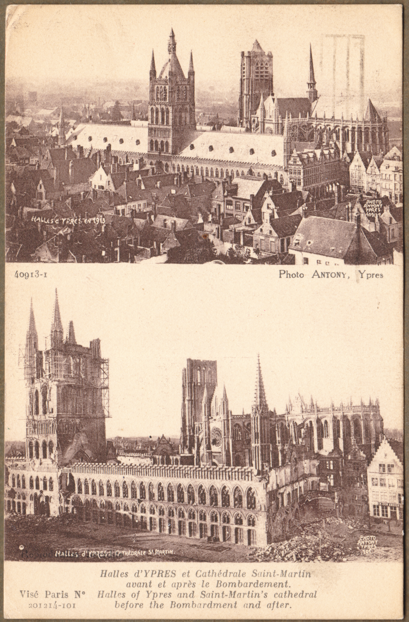
The Cloth Hall was built between 600 and 700 years before the Great War. It was used for ... cloth. Ypres was an important centre of the textile trade and the great hall was used as a market and warehouse.

Our maternal grandfather was there ... as noted above on one of the photographs he collected. You can search for the previous piece on the Canadian Overseas Railway Construction Corps to find out a little about him if you wish.

*  *  *

For Canadian soldiers, this type of postcard recorded the terrible destruction they had seen, and what had existed before the war.


A Lieutenant Ernest James Scott died on 3 May 1917. 
He is buried at Ecoivres Military Cemetery, Pas de Calais, France

*  *  *


Before drones and satellites, the first primitive airplanes and balloons were used for reconnaissance.
Planners needed to know where enemy troops were and where their artillery was located.

Any significant surviving tall building was used for reconnaissance.
Church steeples and Cloth Halls were used for this purpose.

*  *  *


The crest in the lower left corner is a French postcard artist trades symbol.

*  *  *


*  *  *


*  *  *

from: The Western Front, 1914-1916; Michael S Neiberg; 2008; Amber Books.

Above: A view of part of Ypres after artillery bombardment.


*  *  *


Passchendaele - Third Battle of Ypres

Churchill referred to this battle as 'a forlorn expenditure of valour and life without equal in futility'.


from: The World War, Vol II; ed. Holland Thompson; 1920; Grolier.

You can see the front line approaching Passchendaele at the right side of the map.

*  *  *

from: The World War, Vol II; ed. Holland Thompson; 1920; Grolier.

A closer look, above. You can see the main tactical ridge at the right.
The Germans would have had machine guns in pillboxes and artillery on other surrounding high ground.
Notice 'Anzac' and 'Black Watch Corner' labels to the south-west of the ridge.
I believe the unnamed hills are often identified by the first digits of their stated height on military (topographic) maps.

If you follow the meandering lowland drainage patterns on the map above, 
you can bet that they have become completely disrupted by artillery.
Buildings and roads depicted on the map would also be unrecognizable at ground level.

*  *  *

The last three images were taken during or after Third Ypres.

from: The First World War; Hew Strachan; 2003; Simon & Schuster.

Falling off a duckboard and silently drowning in mud was a significant hazard - particularly at night.
You can't dig trenches here, so built-up sandbagged breastworks would be necessary for defence.


from: The Western Front, 1917-1918; Andrew Wiest; 2008; Amber Books.

Barbed wire entanglements targeted by German machine guns would impede the British forces as they approached pillboxes and artillery positions. 

from: Canada at War; Leslie F Hannon; 1968; McClelland & Stewart.
While those two 'laddered' trees still had branches and leaves, they were used for reconnaissance.
You can see how hopeless it would be to try to attack the enemy occupying the height of land in this environment.


'Mud: We slept in it, ate in it. It stretched for miles, a sea of stinking mud. The dead buried themselves in it. The wounded died in it. Men slithered around the lips of huge shell craters filled with mud and water. My first trip to this awful place was at night. For it was at night that men crept out of their holes at Passchendaele like rats. On each side of the duckboard track lie the debris of war. Dead mules. Their intestines spewed out like long coils of piping. Here an arm and a leg. It was a nightmare journey. Finally dawn broke, a hopeless dawn. Shell-holes and mud. Round-about rifles with fixed bayonets stuck in the mud marking the places where men had died and been sucked down.'

Private A.V. Conn. The Western Front, 1917-1918