Showing posts with label World War One. Show all posts

02 November 2025

Fighting the Last War

As trains operate over the Bolan and Khojak Passes in Balochistan, a small army of YouTube videographers records the trains of the Pakistan Railways. 

The imposing tunnel portals, often displaying their original tunnel names, attest to their British origins. English seems to be the formal operating language of the railway. 

... At one point, trains reach a manual semaphore set at stop. They face a switch normalled for a long, steep, runaway track. After satisfying the switchman occupying a miniscule shanty, the diverging route is set for the main line, clearing the semaphore. 

Tall, fortified, brick water towers with abundant loopholes in all directions ... and isolated desert station compound ruins, which are walled and equipped with a central water source ... can also be seen. 

... The civil engineering challenge of providing adequate water for steam locomotives, by itself, would have been a major task in this (usually) arid region.

from: Citizen's Atlas; 1924; Bartholomew.

Commerce and military transportation are two time-honoured reasons for building railways across foreign colonies.  

On the century-old map above, railways are shown as dashed lines. Beginning in the top, left corner and working down to the bottom, right corner, you will see:
  • Kandahar, Afghanistan.
  • Chaman, Balochistan, Pakistan - the end of the line ... and Khojak Pass, with its summit tunnel.
  • Quetta - a city of about 1.5 million people, where many of these video journeys begin.
  • Bolan Pass - another summit tunnel and the location of a runaway track.
  • Sibi - a featured destination on one of the remote branch lines.
*  *  *

I've just discovered/watched a few Sites and Sounds videos, but they are shot using excellent equipment so you can enjoy them on a large screen.

I've watched many from Quetta Railography and he is a sympathetic character who often rides the outside of the unit to video.


Above: I think this runaway track is on the line descending from Bolan Pass.

*  *  *


Above: At the tunnel entrance, you can see the cot of the worker who is probably the trackwalker.
Sometimes, armed military and para-military personnel protect facilities from the local separatist movement. 

*  *  *


I think this is a trip to Sibi. The line suffered significant damage from torrential rains. 
Sometimes large bridges are taken out on the main line.

Notice the nose of this 'branch line' engine.
They look different on the outside, but inside I can often hear an SD40-2 or enjoy a smoking Century.

*  *  *


This is the 'northbound' portal of Khojak Tunnel. Built in 1891, it is 2.4 miles long.
In Pakistan and Bangladesh, you can often see old interlocking rods, semaphores and unused signal towers.

By our standards, the passenger rolling stock in these countries often shows abundant hazards and arch-bar-style trucks can be seen sometimes. However, the railroaders in Canada and Pakistan would find they have a lot in common if they visited each other's cabs.

As I mature in my interests, I marvel at the enduring efficiency of these old and sometimes under-maintained railway systems. There is a lot of classic railroading taking place on these lines - without the aid of hi-rail equipment or gasoline-powered maintenance of way tools. Trains often operate with 20 coaches as these lines provide essential transportation for much of the population.

*  *  *

Bureaucracy gets a bad name.

Often used as a synonym for 'obstruction', 'bureaucracy' is often viewed with disdain. However, when it is working properly, a bureaucracy organizes the work of, and preserves the culture of, a large organization. We would not want hospitals or police departments 'winging it' if new employees decided ... that Operating Room infection control masking is 'over the top' ... or that 'shooting a few crooks' would 'send a strong message'. 

Few organizations have more rigid written rules to follow than railways and the military. Generally, these rules are in place because they have been proven to lead to successful outcomes, save lives and prevent the loss of expensive equipment.

Health care and the military came together in this 1912 Manual of Elementary Military Hygiene. The British generally went into their dominions, colonies, and their Crown Rule in India with a robust military presence. 

To ensure success, they had to keep their soldiers healthy. You'll notice that the statistics they use are mostly from very warm places - nothing like the invigorating climate of British North America.


Here are the criteria to be considered when planning the hygienic layout of a typical camp.


If you look at the statistics below in Appendix I for Afghanistan (1878-80) and North-West Frontier, India (1897-8) I think they want us to acknowledge that disease causes more admissions and deaths ... than 'killed and wounded in action'. 

And this is often the case for foreign troops in wars, shown in Appendix II.


Rations to be provided on a daily basis are carefully specified in Appendix III.

In Appendix IV, it is important to ensure that soldiers housed and sleeping in barracks have adequate space.


 ... so that was 'The Last War' ...


*  *  *


World War I

The Next War.


It caught most well-trained and experienced military leaders by surprise 
and condemned their conventional efforts to failure.


from: Light Railways of the First World War; WJK Davies; 1967; David & Charles.

In the First World War, fighting was conducted in virtually all climates around the globe. However, the main preoccupation was with the European Front. It provided an early example of industrialized war. Trains delivered mass-produced weapons, ammunition and canned rations as close as possible to the Front.

If soldiers could be evacuated beyond the range of artillery, disease could be treated under civilized conditions. Wounds experienced in the trenches under fire were another matter. Soldiers lived in ditches and holes because they saved lives.

The 'hay ride' above is being photographed in 'the Rear' ... there are bushes and trees which have not been splintered by artillery. Smoke-producing steam engines would not be permitted within sight of enemy artillery observers because they would become instant targets.

*  *  *

from: World War I in Photographs; JHJ Andriessen; 2002; Rebo.

Above: These burrowing soldiers have probably violated old hygiene regulations for barrack construction. 
They are probably still in artillery range.

While thousands died in pointless attacks resulting in gains measured in yards ... 

From time to time, there were successful offensives 
which got soldiers out of their deadlocked, sewage filled ditches.

*  *  *

from: World War I in Photographs; JHJ Andriessen; 2002; Rebo.

Given the range and effectiveness of artillery (and machine guns and snipers), 
it was sometimes impossible to bring food and water to the front line trenches 
... or to rotate troops to an area in the rear for scheduled rest. 

Basic sanitation and burying the dead were often improvised on the spot. 

With heavy bombardments and static trench areas, the dead did not stay buried.

*  *  *

from: World War I in Photographs; JHJ Andriessen; 2002; Rebo.

Draft animals suffered terribly - particularly in the mud.
The alternative was using human bearer parties for freight.

Horses or mules were essential for moving heavy guns.
Animals killed by enemy artillery added to the hygiene nightmare.

*  *  *

The Guide
A Manual for the Canadian Militia

(The 'Canadian Army' title did not exist formally until 1940.)

This 1880 book was updated and rushed out the door - typical of most activities of the early war.

It assumed that the future would bear a resemblance to the past.

In its 300 pages, it provides the institutional memory necessary to organize all aspects of an army.

However, it has nothing on how to provide bureaucracy - or anything else - in trenches teeming with well-fed rats, under regular shelling, with clouds of poison gas silently drifting across No Man's Land, or dispensed in deadly puffs from artillery gas shells. 

Nowhere does it suggest, when advancing into the overlapping fields of fire of enemy machine guns, how to safely pass barbed wire entanglements during the course of an attack.


Over the din of battle, it had long been prescribed that commands were
to be communicated and relayed by a loud portable device powered by human lungs.

After World War One,
two everyday pieces of music were transposed in commemoration ceremonies
... to represent human death, followed by a resurrection. 

Here, they appear in their normal daily sequence.


from: The Battle of the Somme; Martin Gilbert; 2006; McClelland & Stewart.

Having been relieved from their front-line positions, 
Canadian troops are rotating into a rest area.

It was about 30 years after World War One that the booklet, below, was published.

However, an (unsanctioned) song from that war reflects 

the old traditions (a rum ration), 

the perceived daily occupations of the more privileged ranks,

and a notorious technology of World War One
(the barbed wire entanglement).


YouTube link:

Hanging on the Old Barbed Wire 

from: Oh! What a Lovely War (1969)


10 November 2023

Ypres (Ieper) Postcards and Maps from the Great War

There is a reason why a painting of the ruins in Ypres (among others) was commissioned for a Canadian museum of the Great War ... or World War. The museum was never built and that painting (among those others) has been displayed in the Senate of Canada.

The Reason: Ypres (today known as Ieper) was one well-remembered location which most Canadian soldiers passed by ... on their way to, or from, battle ... at some point in the war.

The map below shows the area of Flanders where Canadian forces often fought. 

As a generalization, the French took care of business to the south of the Somme River. Other British Empire and 'dominion' forces were often north of the Somme. The Anzacs and Newfoundlanders could sometimes be found in Egypt or in the Dardanelles. And so on - it really was a world war, as many of the various empires' colonies were drawn into the conflict.

  • That particular corner of Belgium where Ypres is located was the only corner of Belgium which was left unoccupied by the German Empire - so plucky little neutral Belgium, and its popular king, lived on and was free.
  • That corner had a secondary symbolic value. The antiquated treaty intended to protect Britain from French invasion ... yes, really ... was Britain's reason for getting involved in the European War: 'Belgium must remain neutral'. 
  • And that same proximity to the Channel and England meant that places like Dunkirk and Calais had to be protected from German capture. The British Empire armies on the continent needed to import all the food and materials necessary to carry on the war.

from: from: Canada at War; Leslie F Hannon; 1968; McClelland & Stewart.

The Second Battle of Ypres involved German forces releasing poison gas (chlorine) as a weapon of war for the first time on the Western Front. They had already experimented with gas shells on the Eastern Front. Canada was key in preventing the line from collapsing as the Germans followed their gas and attacked. The date: 22 April to 25 May 1915.

The Third Battle of Ypres, or Passchendaele ... (today Passendale) ... was a pointless exercise and involved fighting through an endless bottomless sea of infectious mud while under fire from the Germans - shooting down from the high ground. Other Empire forces failed to capture the heights. The Canadians succeeded. The date: 31 July to 10 November 1917.

Generally, British troops often anglicized hard-to-pronounce foreign place names, so to many Ypres was 'Wipers'.

*  *  *

from: Borden, His Life and World; W Kaye Lamb; 1977; McGraw-Hill Ryerson.

Book caption: 'Eager recruits forcing their way into the recruiting centre in Ottawa in the first days of the First World War. No one had any conception of what lay ahead; the chief anxiety of many was fear that the war would be over before they had a chance to participate in it.'

 The term of enlistment was 3 years or for the duration of the war.

*  *  *

from: The World War, Vol I; ed. Holland Thompson; 1921; Grolier.

The contemporary map, above, shows that continuous line of trenches - running from Switzerland to the sea.

*  *  *

from: The World War, Vol I; ed. Holland Thompson; 1921; Grolier.

On the map above, you can see other reasons why the Germans had an interest in Ypres. 
It was a transportation centre with railways, canals and roads passing through it.

*  *  *

from: A Pictorial Memoire of World War One by James Scott Parke; Laura Anne Lee; 2001; self-published.

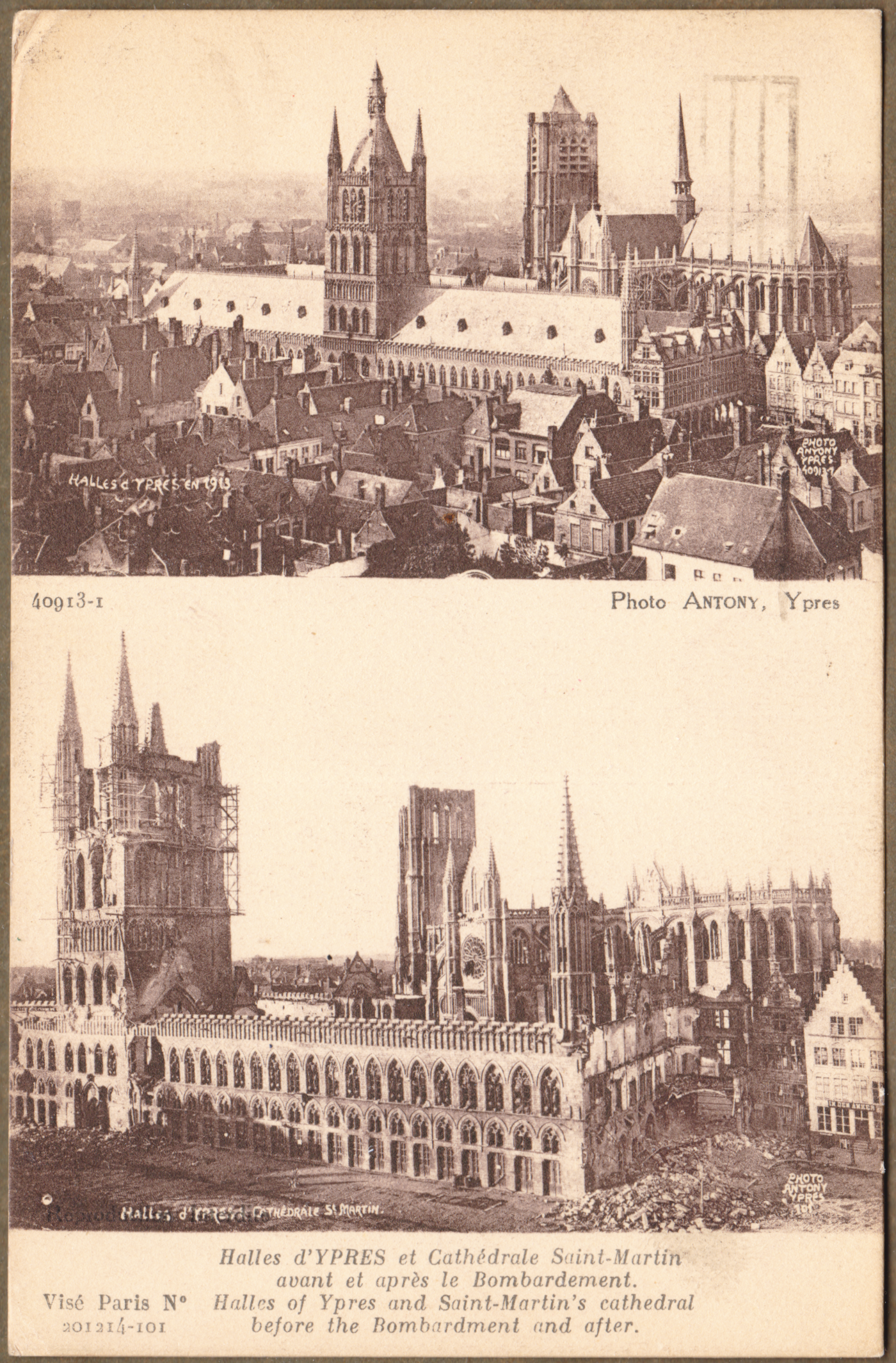
The Cloth Hall was built between 600 and 700 years before the Great War. It was used for ... cloth. Ypres was an important centre of the textile trade and the great hall was used as a market and warehouse.

Our maternal grandfather was there ... as noted above on one of the photographs he collected. You can search for the previous piece on the Canadian Overseas Railway Construction Corps to find out a little about him if you wish.

*  *  *

For Canadian soldiers, this type of postcard recorded the terrible destruction they had seen, and what had existed before the war.


A Lieutenant Ernest James Scott died on 3 May 1917. 
He is buried at Ecoivres Military Cemetery, Pas de Calais, France

*  *  *


Before drones and satellites, the first primitive airplanes and balloons were used for reconnaissance.
Planners needed to know where enemy troops were and where their artillery was located.

Any significant surviving tall building was used for reconnaissance.
Church steeples and Cloth Halls were used for this purpose.

*  *  *


The crest in the lower left corner is a French postcard artist trades symbol.

*  *  *


*  *  *


*  *  *

from: The Western Front, 1914-1916; Michael S Neiberg; 2008; Amber Books.

Above: A view of part of Ypres after artillery bombardment.


*  *  *


Passchendaele - Third Battle of Ypres

Churchill referred to this battle as 'a forlorn expenditure of valour and life without equal in futility'.


from: The World War, Vol II; ed. Holland Thompson; 1920; Grolier.

You can see the front line approaching Passchendaele at the right side of the map.

*  *  *

from: The World War, Vol II; ed. Holland Thompson; 1920; Grolier.

A closer look, above. You can see the main tactical ridge at the right.
The Germans would have had machine guns in pillboxes and artillery on other surrounding high ground.
Notice 'Anzac' and 'Black Watch Corner' labels to the south-west of the ridge.
I believe the unnamed hills are often identified by the first digits of their stated height on military (topographic) maps.

If you follow the meandering lowland drainage patterns on the map above, 
you can bet that they have become completely disrupted by artillery.
Buildings and roads depicted on the map would also be unrecognizable at ground level.

*  *  *

The last three images were taken during or after Third Ypres.

from: The First World War; Hew Strachan; 2003; Simon & Schuster.

Falling off a duckboard and silently drowning in mud was a significant hazard - particularly at night.
You can't dig trenches here, so built-up sandbagged breastworks would be necessary for defence.


from: The Western Front, 1917-1918; Andrew Wiest; 2008; Amber Books.

Barbed wire entanglements targeted by German machine guns would impede the British forces as they approached pillboxes and artillery positions. 

from: Canada at War; Leslie F Hannon; 1968; McClelland & Stewart.
While those two 'laddered' trees still had branches and leaves, they were used for reconnaissance.
You can see how hopeless it would be to try to attack the enemy occupying the height of land in this environment.


'Mud: We slept in it, ate in it. It stretched for miles, a sea of stinking mud. The dead buried themselves in it. The wounded died in it. Men slithered around the lips of huge shell craters filled with mud and water. My first trip to this awful place was at night. For it was at night that men crept out of their holes at Passchendaele like rats. On each side of the duckboard track lie the debris of war. Dead mules. Their intestines spewed out like long coils of piping. Here an arm and a leg. It was a nightmare journey. Finally dawn broke, a hopeless dawn. Shell-holes and mud. Round-about rifles with fixed bayonets stuck in the mud marking the places where men had died and been sucked down.'

Private A.V. Conn. The Western Front, 1917-1918

05 November 2023

1915 - The Roll of the Canadian Overseas Railway Construction Corps & An Artifact Finally Reproduced

Many years ago, my father (LC Gagnon) received a couple of artifacts from my maternal grandmother because he was 'interested in trains' and, of course, he had been employed by the Canadian Pacific Railway.

First, here is the nominal roll of personnel in the Canadian Overseas Railway Construction Corps. 

If you are not acquainted with the work they did, here are a couple of photos as a quick introduction.

from: The Railway Contractors; Geoffrey W Taylor; 1988; Moriss Publishing. 


The Canadian railway boom exhausted itself as the Great War began. Few countries had as many workers with so much knowledge and experience building railways through irregular muskeg 'wasteland' as Canada.

By 1914, the 'old style' warfare of parade-square engagements on European battlefields was dead. The glamour of the cavalry performing reconnaissance ... or chasing down routed infantry with sabres drawn, was gone. Instead, for the immediate future, draft horses and mules would be needed to pull artillery and other loads where roads or tramways could be maintained ... and to prepare the way for the iron horse. 

For battlefield killing using vast quantities of artillery shells and other mass-produced armaments, the combatants would need industrialized transportation.

Canadians, and slightly-Canadianized immigrants from the British Isles (see the roll below), would be filling the demand for more and more railways. All these railways eventually reached a human-made wasteland - which was produced at great cost and known as The Front.


From past experience, I believe you can find this and other similar documents at archive.org

The Canadian Government's microfilm records are digitized and searchable there.


*  *  *

In the late stages of emptying our parents' house, I encountered a deep, safe corner behind shelves and filing cabinets where large, scrolled items were kept. There they slept under at least 10 years of dust and cobwebs because other events had demanded the attention of their owner.

... Entire forests had been harvested to produce all the Masonic and Shrine scrolls awarded to my paternal grandfather (a school teacher and principal) and his father (an Anglican minister). 

Another rolled-up item seemed to have been through a war or two. It was an university course design project in railway civil engineering. Perhaps it was the equivalent of an assignment in 2023 to design a large, integrated wired-wireless network for a given purpose ... in other words, a good representation of the technology and design norms of the era. 

I find it interesting as an artifact because it represents a piece of tangible geography, which would be the workplace of hundreds of people, employing thousands of pieces of railway equipment, in a bygone era.

Since finding this plan, I have always wanted to reproduce it on-line so that it will be more likely to survive outside of a dusty, hidden corner. However, I was at a loss as to how to produce a 'scanned quality' image without actually scanning it. 

... Fortunately, more powerful laptops with solid state drives ... and some recent difficult experiences with a scanner and image software ... finally made this project conceivable. 

The treated paper is about 6.5 feet long by 2 feet, and my scanner has a working area of about 8.5 by 11.5 inches so I had to unscroll/scroll and scan it in 3 courses from side to side. I didn't want to risk damaging the artifact so it was not always possible to get perfect contact with the scanner's glass. The images I have produced are not beautiful, but you will be able to 'read' the plan and understand the logic employed by the designer over 108 years ago.


The image above and the history below come from: 
The Park Family of Stewartstown, County Tyrone, Ireland & Their Descendents, Volume 3; Jean Isabelle Parke Lee; 1996; self-published.

... My maternal aunt was a formidable researcher and database compiler - as illustrated by this genealogical work. 


... and now you know as much about my maternal grandfather as I do. 

In our family ... or in larger family gatherings with my grandmother, or my aunt's family ... he wasn't spoken about very much.

In her later years, my mother did say that she and her father would sometimes walk north into the woods - starting from their home in east-end Lachine, where they lived at that point. However, to my mother's regret, this natural area was soon taken over by 'the railway'. 

... I now conclude that she was referring to the CPR, as it built its new St Luc yard. Thinking of this Divisional Yard plan ... I wonder ... if it was perhaps this new railway development - and not nature - which attracted my grandfather's expeditions to this area.

For my mother, a striking feature along this nature walk was 'the dead horse'. How many dead equines had a Great War battlefield veteran seen in four years?

*  *  *

A straight photograph of the Divisional Yard plan appears below. Toonies hold it flat. The floor divisions are about 6 inches.

The yard itself is appears as black and red. There are three large areas (black ink) which elaborate on segments of the yard.


Below: To make the design easier to see as you run your equipment through the yard from left to right, and vice versa, I have rotated the yard (red and black) so its main axis is horizontal. The black ink elaborations are itemized below in separate images.

You can see that the eastbound workflow travels along the south side of the yard ... while westbound workflow travels along the north side.

Scales and interlocking towers mark the locations of two gravity classification humps. At the bottom of the humps are found the eastbound and westbound classification yards. A complete track profile for the humps is also presented at these two locations. 

... As this yard was designed in 1915, I assume that these are relatively 'short, shallow' humps because yardmen with clubs would be riding the cars/cuts ... and winding on the roof-mounted handbrakes to avoid hard collisions with the standing cars - many of which would still be made of wood. This would also be before the era of roller bearings on freight cars. Steeper humps with human- or computer-actuated mechanical retarders became standard in Canada several decades later.

To quibble: I don't see a caboose track identified anywhere.  We could tuck them in by extending those two leads south of the coaling tower. And considering the engine crews - it would have been efficient, but not necessarily quiet for sleeping, to have their bunkhouse so near the roundhouse. But perhaps after working for half a day, exposed to the elements aboard a deafening and lurching steam locomotive ... one had little trouble getting to sleep after booking in.

Within the main yard plan you can see dashed lines outlining the 'cut out' areas for elaboration in black ink.


*  *  *

The black ink details ...


Detail 1 ... East main switch.

Detail 2 ... West end of Eastbound Classification Yard - south of roundhouse.

Detail 3 ... Switch and tracks by coal/sand.


One wonders how different 22-year-old  J Scott Parke's  life would have been if the Great War had not intervened and he had completed his professional training.