There is a reason why a painting of the ruins in Ypres (among others) was commissioned for a Canadian museum of the Great War ... or World War. The museum was never built and that painting (among those others) has been displayed in the Senate of Canada.
The Reason: Ypres (today known as Ieper) was one well-remembered location which most Canadian soldiers passed by ... on their way to, or from, battle ... at some point in the war.
The map below shows the area of Flanders where Canadian forces often fought.
As a generalization, the French took care of business to the south of the Somme River. Other British Empire and 'dominion' forces were often north of the Somme. The Anzacs and Newfoundlanders could sometimes be found in Egypt or in the Dardanelles. And so on - it really was a world war, as many of the various empires' colonies were drawn into the conflict.
- That particular corner of Belgium where Ypres is located was the only corner of Belgium which was left unoccupied by the German Empire - so plucky little neutral Belgium, and its popular king, lived on and was free.
- That corner had a secondary symbolic value. The antiquated treaty intended to protect Britain from French invasion ... yes, really ... was Britain's reason for getting involved in the European War: 'Belgium must remain neutral'.
- And that same proximity to the Channel and England meant that places like Dunkirk and Calais had to be protected from German capture. The British Empire armies on the continent needed to import all the food and materials necessary to carry on the war.
 |
| from: from: Canada at War; Leslie F Hannon; 1968; McClelland & Stewart. |
The Second Battle of Ypres involved German forces releasing poison gas (chlorine) as a weapon of war for the first time on the Western Front. They had already experimented with gas shells on the Eastern Front. Canada was key in preventing the line from collapsing as the Germans followed their gas and attacked. The date: 22 April to 25 May 1915.
The Third Battle of Ypres, or Passchendaele ... (today Passendale) ... was a pointless exercise and involved fighting through an endless bottomless sea of infectious mud while under fire from the Germans - shooting down from the high ground. Other Empire forces failed to capture the heights. The Canadians succeeded. The date: 31 July to 10 November 1917.
Generally, British troops often anglicized hard-to-pronounce foreign place names, so to many Ypres was 'Wipers'.
* * *
 |
| from: Borden, His Life and World; W Kaye Lamb; 1977; McGraw-Hill Ryerson. |
Book caption: 'Eager recruits forcing their way into the recruiting centre in Ottawa in the first days of the First World War. No one had any conception of what lay ahead; the chief anxiety of many was fear that the war would be over before they had a chance to participate in it.'
The term of enlistment was 3 years or for the duration of the war.
* * *
 |
| from: The World War, Vol I; ed. Holland Thompson; 1921; Grolier. |
The contemporary map, above, shows that continuous line of trenches - running from Switzerland to the sea.
* * *
 |
| from: The World War, Vol I; ed. Holland Thompson; 1921; Grolier. |
On the map above, you can see other reasons why the Germans had an interest in Ypres.
It was a transportation centre with railways, canals and roads passing through it.
* * *
 |
| from: A Pictorial Memoire of World War One by James Scott Parke; Laura Anne Lee; 2001; self-published. |
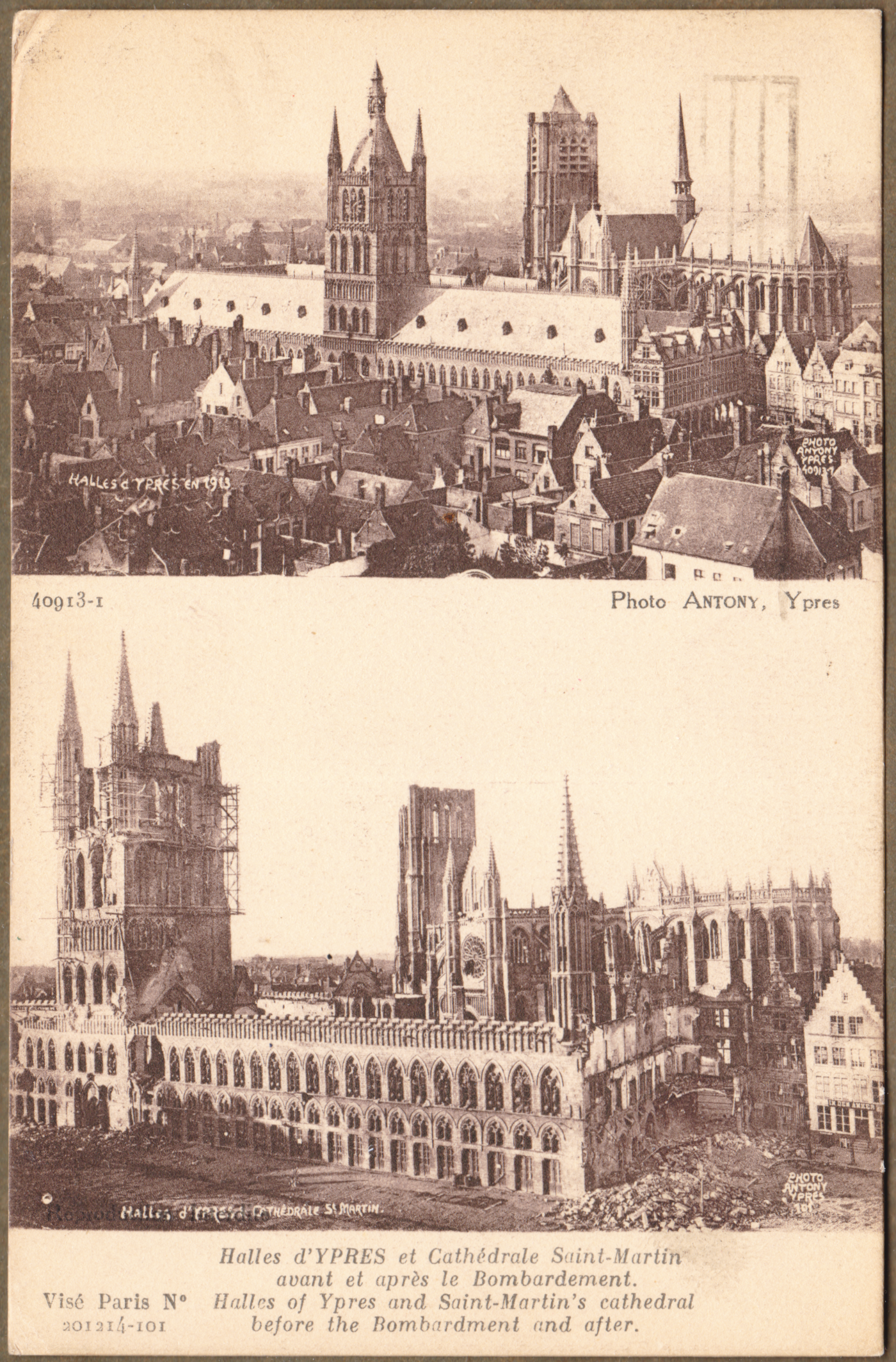
The Cloth Hall was built between 600 and 700 years before the Great War. It was used for ... cloth. Ypres was an important centre of the textile trade and the great hall was used as a market and warehouse.
Our maternal grandfather was there ... as noted above on one of the photographs he collected. You can search for the previous piece on the Canadian Overseas Railway Construction Corps to find out a little about him if you wish.
* * *
For Canadian soldiers, this type of postcard recorded the terrible destruction they had seen, and what had existed before the war.
A Lieutenant Ernest James Scott died on 3 May 1917.
He is buried at Ecoivres Military Cemetery, Pas de Calais, France
* * *
Before drones and satellites, the first primitive airplanes and balloons were used for reconnaissance.
Planners needed to know where enemy troops were and where their artillery was located.
Any significant surviving tall building was used for reconnaissance.
Church steeples and Cloth Halls were used for this purpose.
* * *
The crest in the lower left corner is a French postcard artist trades symbol.
* * *
* * *
* * *
 |
| from: The Western Front, 1914-1916; Michael S Neiberg; 2008; Amber Books. |
Above: A view of part of Ypres after artillery bombardment.
* * *
Passchendaele - Third Battle of Ypres
Churchill referred to this battle as 'a forlorn expenditure of valour and life without equal in futility'.
 |
| from: The World War, Vol II; ed. Holland Thompson; 1920; Grolier. |
You can see the front line approaching Passchendaele at the right side of the map.
* * *
 |
| from: The World War, Vol II; ed. Holland Thompson; 1920; Grolier. |
A closer look, above. You can see the main tactical ridge at the right.
The Germans would have had machine guns in pillboxes and artillery on other surrounding high ground.
Notice 'Anzac' and 'Black Watch Corner' labels to the south-west of the ridge.
I believe the unnamed hills are often identified by the first digits of their stated height on military (topographic) maps.
If you follow the meandering lowland drainage patterns on the map above,
you can bet that they have become completely disrupted by artillery.
Buildings and roads depicted on the map would also be unrecognizable at ground level.
* * *
The last three images were taken during or after Third Ypres.
 |
| from: The First World War; Hew Strachan; 2003; Simon & Schuster. |
Falling off a duckboard and silently drowning in mud was a significant hazard - particularly at night.
You can't dig trenches here, so built-up sandbagged breastworks would be necessary for defence.
 |
| from: The Western Front, 1917-1918; Andrew Wiest; 2008; Amber Books. |
Barbed wire entanglements targeted by German machine guns would impede the British forces as they approached pillboxes and artillery positions.
 |
| from: Canada at War; Leslie F Hannon; 1968; McClelland & Stewart. |
While those two 'laddered' trees still had branches and leaves, they were used for reconnaissance.
You can see how hopeless it would be to try to attack the enemy occupying the height of land in this environment.
'Mud: We slept in it, ate in it. It stretched for miles, a sea of stinking mud. The dead buried themselves in it. The wounded died in it. Men slithered around the lips of huge shell craters filled with mud and water. My first trip to this awful place was at night. For it was at night that men crept out of their holes at Passchendaele like rats. On each side of the duckboard track lie the debris of war. Dead mules. Their intestines spewed out like long coils of piping. Here an arm and a leg. It was a nightmare journey. Finally dawn broke, a hopeless dawn. Shell-holes and mud. Round-about rifles with fixed bayonets stuck in the mud marking the places where men had died and been sucked down.'
Private A.V. Conn. The Western Front, 1917-1918