Showing posts with label map. Show all posts

09 May 2026

LCG 1948 Quebec City, Postcards, Maps & The Gnawing Golden Dog


In 1948 LC Gagnon was using his CPR employee pass to take a few vacation days in Quebec City, staying at the Chateau Frontenac. 

He mailed a folder of postcards back home to his sister.  


I think the top postcard shows a CP steamship heading upriver.

After the first simple wooden palisades, the first phase of Quebec's stone wall defences was built between 1745 and 1759 by the French. They were handy, but not decisive after the Battle of the Plains of Abraham. 

Between 1820 and 1832, the British were encouraged by the War of 1812 to further reinforce the city's wall system. This was also the period during which the Citadel was completed.

Between 1871 and 1881, with the British army gone, local residents began to tear the deteriorating walls down - presumably for their stone. Lord Durham, formerly the Governor General, stepped in to save the almost 5 kilometres of walls. This gate was one of those rebuilt in an ornamental style during that preservation process. 

*  *  *


Looking downriver, we see a couple of ferries, simmering at their docks.


from: Tourist Map of Quebec; undated, circa 1948; Quebec Municipal Tourist Bureau.

This map from the 1948 trip shows the whole wall system nicely. The wall articulates with the Citadel at the left. 

The St Louis Gate can be seen at the wall's '11 o'clock' position. The switch for the double-track section of streetcar track in the postcard matches the track arrangement shown on the map.

*  *  *


Looking downriver from the Citadel, the buildings left and centre can be seen today on Google Maps.

*  *  *

Le Chien d'Or

Last artifact from LC Gagnon's 1948 trip shown in this post.

As World War 2 had been keeping everyone busy, there was little time in the age of coal-burning to clean the stonework of the Quebec City main post office building. Doing his best with his box camera, LC Gagnon photographed the building to document the little figure of a dog over the main entrance. 

A house built in 1688 was demolished to make way for this new building. The actual stone from that house, bearing the image and inscription behind various urban legends, was preserved and included in the new structure.


On our current Google Maps view of the former main post office building, we can see they've restored the dog's goldness.


from: BANQ, postcard image.


from: Le Chien d'Or - A Legend of Old Quebec; William Kirby; 1877; Lovell. archive.org

I'm not going to link to the book as there are more Chien d'Or at archive.org than you can throw a Frisbee to.

William Kirby (1817-1906) was born in Yorkshire and ended up at Niagara-on-the Lake. He was variously a tanner, a school teacher and a newspaper editor. He saw the house mentioned above (built in 1688) 4 years before it was demolished to make way for the main post office building in 1869. He was fascinated by aspects of Quebec City during his visit there. He reportedly first read about the Chien d'Or semi-urban-legend in James MacPherson Lemoine's (1825-1912) Maple Leaves book of Canadian lore (first published: 1865).

Kirby's completed novel was shopped around unsuccessfully until it was finally published by Lovell in 1877. As the publisher failed to register the work, it immediately became public domain. 

The Villain of New France

Decades ago, in my English-language school in Montreal, in Grade 5 ... we learned that Francois Bigot (1703-1778) ... the Intendent of New France, beginning in 1748 ... was a corrupt colonial administrator who used his office to make large amounts of money at the expense of the colonists he was supposed to be serving. His preference would have been a comfortable administrative post in a French port but they sent him to Canada instead.

Bigot's negligence facilitated the loss of France's colonies in Canada. We all do well to remember that France's forsaking of these colonies in favour of keeping warmer ones was also a major factor in their change of ownership.

One of the Two Legends ( ... life is too short for both ... )

The virtuous merchant Nicolas Philibert, owner of the house, must have clashed with the corrupt Bigot - perhaps inspiring the installation of the Chien d'Or stone in 1736. In 1748, he was killed during a quarrel with a soldier over a billeting arrangement. Was it a quarrel or a conspiracy? What really happened to his killer? Did the latter finally meet his fate in India? Who saw to the killer's fate?

It would be great to know the true historical facts. However, this is a legend - a tale which people told, altered, and re-told ... before modern, labour-saving inventions like social media.

Writing a Novel

So our friend Kirby took two tragic urban legends of New France and wove them into the contemporary theme of Bigot's real-life corruption. Bigot ... and the words Kirby has him speak ... is actually the book's main character. 

CanLit or History?

The historical motivation for the real 1736 Chien d'Or inscription on the house built in 1688 has never been spelled out by anyone. 

Some have suggested there is evidence the origin of that image and that inscription is not necessarily that particular merchant's house in Quebec City - it may have been copied from another place.

The legends live on.

*  *  *


This unused, undated postcard looks downriver, showing a wide variety of ship technologies in Quebec's harbour.

*  *  *

from: BANQ, published 1905.

This postcard image from BANQ shows the docks of Quebec directly under the Durham and Dufferin terraces. Some will recognize the company name for its various river boat/shipping endeavours. 

You can also see 'the most photographed hotel in the world' before it earned that distinction.

*  *  *


Unused postcard, published 1911.

I haven't checked, but my postcard (circa 1911) above may show an observation streetcar like Montreal's 'Golden Chariots' which has a shorter wheelbase to better navigate the tight turns and hills of Quebec City.

*  *  *

I'm certain I found this excellent map at BANQ but I failed to bookmark it so I only have the original file name as a reference in case someone wants to find it. 
I did spend an hour or two trying to locate it so I could provide a decent link - to no avail.

With two corners numbered, the map must have come from a large-format atlas. Based on the railways labelled, the map may be from circa 1880-1885. However, changing the printing plates for the sake of updating the ever-changing railway names may not have been a priority. 

The Quebec and Gosford was an economical 'wooden railway' with the rails made of maple. Its 26-mile route operated for 4 or 5 frustrating years, with heat, cold and moisture creating the understandable problems with its unique track structure. There is no evidence that the usual iron bands were nailed to the wooden rails to create the famous 'snake rails' which would spring up through car floors. 

The reason for this wooden railway's creation was ... wood. Apparently it was built to provide Quebec City with both lumber and cordwood for fuel - hauled in from the hinterland.


from: BANQ 174243_06.jpg (unable to find the URL again)


end

25 April 2026

TTC 1943 Route Maps, Fares, Wages

LC Gagnon obtained this map of Toronto Transit Commission services in 1943. 

At various times, his grandfather - a dairy farmer living near Lachute, Quebec - sent 'a car' of livestock down to the Royal Winter Fair to show them - or to sell them in some cases. This was in the period when livestock could ride in boxcars with attendants. However, there was no 'Royal' in Toronto during the Second World War as the military had taken over the exhibition grounds. So the reason for this map acquisition is not clear.

The first of the TTC's 700-odd PCCs arrived in 1938. In an official 1953 history of the TTC, they were identified repeatedly as 'Streamliners' and not PCCs. The period of Art Deco styling and aviation-style streamlining influenced the design of many items in the 1930s and 1940s. 'Streamliners' they remained into the 1950s. Unless they were operating along an urban canyon into a howling blizzard, we can guess that their aerodynamics were never employed to advantage.

The cheap, resource-sparing wartime printing and dyes are evident in the image below. Before minor computer-tweaking to bring out detail, the prevailing colour of this cover today is almost a uniform, muddy brown. 

In wartime, or at any other time, there can be no obvious reason why someone would wear a Robin's egg blue suit when coal smoke and soot were ever-present features of urban life ... unless they needed to stand out when posing in front of the dark interior of a PCC streetcar.

As Toronto would have been an important centre for the intake of civilian personnel into the military, we can imagine that incredible numbers of these maps were produced to help these newcomers navigate in the Big Smoke. As Toronto citizens went into the military from their local civilian jobs, we can also assume that many replacement workers were also coming as newcomers to replace them in Canada's second city.

The TTC information (all of it is reproduced below) is on one side and a generic gas station streetmap (by the HM Gousha Company) of the city appears on the reverse. As usual, the latter provides no interesting information on the location or features of particular railway facilities. 


A Canadian dollar in 1943 is the same as $19 today, compensating for inflation.


Below, you'll find fares.

At the very end, you'll find wages from a 1953 TTC-published history.


Today, based on 1943 data and using 2026 dollars ...

A single ticket for the main system would cost $1.18 .

Operators of single-operator streetcars, and buses received wages of $13.87 to $14.82 per hour.
One week of vacation per year.

Two weeks of vacation were provided in 1946 ... until 20 years of service was achieved.


end of TTC map

*  *  *

From: Wheels of Progress; 1953; Toronto Transportation Commission.


end

09 January 2026

BCR 1971 Public Timetable (Pacific Great Eastern)

Including a detailed system map, this attractive and informative little document is well-designed and fits a lot of information into its 8 x 9.5 inch sheets. 

The last image shows both sides of a fare supplement sheet included with the timetable.


Two previous posts on the BCR/PGE are linked below:

PGE 1958 Official Guide ... and Other Items

BCR 1984: 2860 from North Vancouver to Squamish


03 October 2025

CPR 1982 Windsor - Detroit, Local Rail Maps for Shippers

Six railways and two barge lines utilize the Windsor gateway, they say.

This was a year before Minivan production began and 49 years after rum-running ended. 

The Canada–United States Automotive Products Agreement (the Auto Pact) of 1965 was in effect.

Was it the 'good old days'? 

Not if you were trying to buy a house (or a Minivan). The mortgage rate was a little over 19%. Annual inflation was running at about 11%. 

I don't remember where I got this set of two glossy cardstock handouts for CP Rail freight customers. They're old enough to provide an interesting historical contrast to the state of transportation today. 


Some previous posts have also included this region ...


GTR 1915 Public Timetable, West of Detroit & St Clair Rivers


22 November 2024

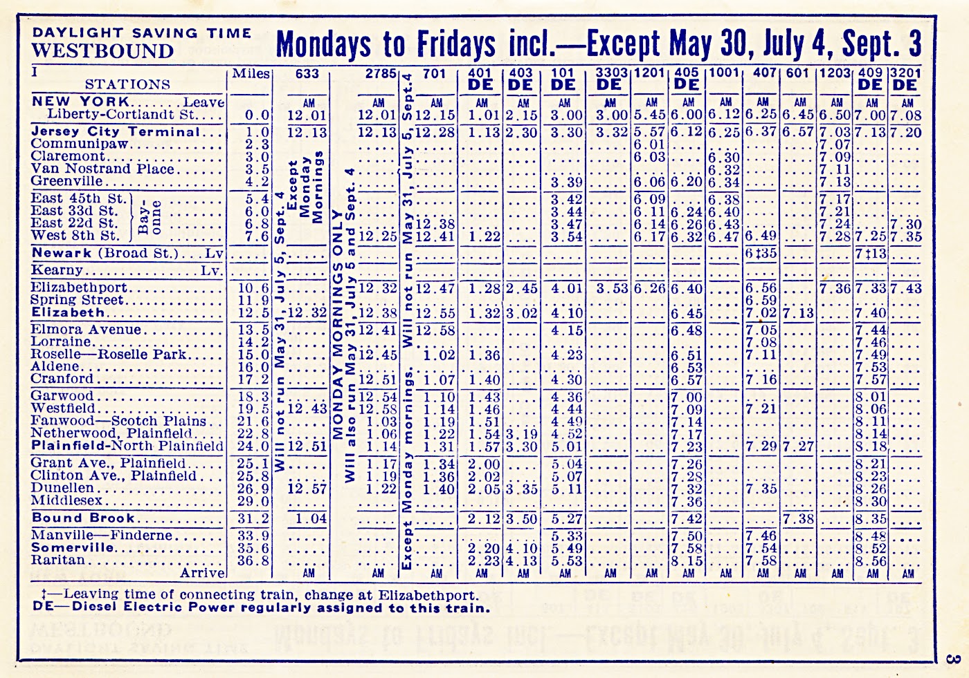
CNJ 1951 Public Timetable, Suburban Trains

Notice the double-ended Baldwin 'babyface' unit on the cover.

The Big Little Railroad occupied a particular economic niche in transporting suburban New Jersey commuters to Manhattan by rail and ferry. For many years, another profitable business of the CNJ was hauling anthracite coal. 

As these two lines of business became increasingly obsolete in the 1950s, the railroad suffered ... from its lack of 'bridge traffic' income ... from the stranded capital in its obsolete coal-powered commuter motive power and coaches ... and from the extensive physical plant it maintained in urban settings. 


*  *  *
The map below shows good station detail for most of the important Jersey Central lines. The Reading obtained control of the CNJ in 1901 ... and the B&O bought the Reading. The objective of the B&O was to get access to New York City via those other two lines. 

The CNJ had some really large steam power for its freight business which included its traditional anthracite lines into Pennsylvania. A couple of photos are shown at the end of this post.

from: Official Guide, June 1941.

*  *  *
The map below identifies all of the important commuter stations in the timetable.

from: Northeast Railroad Scene, Vol 5 The Jersey Central; Bob Pennisi; 1980; Railroad Avenue Enterprises.

*  *  *
The old 1912 map, below, shows how CNJ's ferries connected the New Jersey commuters with Manhattan.

from: Industrial Review of New York; 1912; George F Cram.
from: Jersey's Own Railroad; William R Frutchey; Trains, Dec 1946; Kalmbach. 

The camel-back locomotives were apparently designed to provide a large grate area for the slow-burning anthracite coal. This low-smoking hard coal was in high demand for urban space heating and substantial deposits were in production on the Pennsylvania end of the CNJ. 

On the camel-backs, the engineer occupied the 'well-heated' cab which straddled the boiler and the fireman took his traditional place with his shovel at the backhead of the boiler where he could get a nice sun tan. This arrangement was tolerable for commuter service, but it is hard to imagine engine crews happily working on these engines in the 1940s.

On the excellent public relations video linked at the end of this post, there are only two very quick glimpses of these anachronistic locomotives shown. 


This is the end of the Monday-Friday westbound timetable.
Saturday/Sunday westbounds are below.


*  *  *

from: Diesels from Eddystone; Gary & Stephen Dolzall; 1984; Kalmbach.

On 6 November 1946, Baldwin and CNJ officials celebrated the delivery of a DR-6-4-20.

*  *  *

Here are the Monday to Friday eastbound timetables.


The Saturday and Sunday eastbounds are shown below.


Accounting for inflation ... a US dollar in 1951 equals about 32 US dollars in 2024.


This transfer was found between Pages 28 and 29 of this timetable.

*  *  *

from: Jersey's Own Railroad; William R Frutchey; Trains, Dec 1946; Kalmbach. 

Above: The eastern terminal of the CNJ, Reading and Baltimore & Ohio at Jersey City. 
The engine in the photo is pushing a passenger consist into the stub-end terminal at the water's edge. 

When I was preparing the image I had to double-check ... 
yes, indeed, that is the Manhattan skyline beyond the signal bridge. 
You know ... if everyone wasn't burning so much coal ...

*  *  *

from: Jersey's Own Railroad; William R Frutchey; Trains, Dec 1946; Kalmbach. 

Above: The service tracks outside the Jersey City roundhouse.

*  *  *

A very good  25-minute YouTube video ...

On YouTube I've watched many short railroad publicity films from the 1940s and 1950s. The film linked below is one of the most interesting ones I've seen. Above all, it maintains a brisk and energetic pace. It shows a great amount of railroad operating detail. There are a few unusual pieces of equipment and operations one doesn't often see in these videos.
  • In keeping with its optimistic message, only two quick views of the old camel-back engines are shown.
  • The Ashley Planes are shown in operation. This was an old-fashioned 14-degree (max) inclined-plane standard gauge branch (primarily for coal) ... powered by stationary engines and used until the late 1940s.
  • A particular hopper car is shown being loaded from an enormous old anthracite pit and we see it a few times as we follow the line-narrative from Pennsylvania ... to the unloaders at the waterfront opposite New York City - where the same car is emptied.
  • Two types of Baldwin 'babyface' units are shown being used in passenger service.
  • A Jordan spreader is seen in action during ditching. And a large primitive Speno ballast cleaner operates as well.
  • CNJ passenger ferry, car float and lighter operations are shown.
  • A tender-top generator for commuter car interior lighting is seen. 
  • The original 'oil-electric' locomotive ... which had been working continuously on a Class 1 railroad since 1925 ... is seen in two views. This was the Alco/GE/IR boxcab used at the (fascinating, modeller's favourite) water-isolated 'Bronx Terminal'. A couple of short clips show it in operation. One source said that oil-electric was the preferred term in 1925 because the Germans had just been defeated in The War, and calling it a Diesel-electric after the motor's inventor would not have seemed appropriate.
  • Bonus: You can hear Mauch Chunk and Wilkes-Barre pronounced by a professional!