One can compare and contrast the two tunnels through these cards. In fact, two of them offer key data about their respective tunnels on the message side.
While I've made a point of seeing both tunnels, I still get them confused from time to time.
* * *
Only by finally looking at the message side of the cards closely ... did I observe that one of them had probably reached its recipient at a critical moment during the Second World War. Furthermore, the addressee was probably directly involved in a famous battle. The postmark was stamped on 15 August 1940. Margate is 20-25 miles north of Dover - although it is not clear if this is an originating or receiving postmark.
During the Battle of Britain, August 13 to 18 marked the period of the most concentrated attacks on British airfields and radar installations.
August 13 was Adlertag - concentrated raids by the massed Luftwaffe forces against RAF airfields in the southeast of England, designed to wipe out any air defence by fighter aircraft.
The highest RAF losses were recorded on the ground on August 18 as aerial battles raged above.
Gunner Fisher may not have attended a gun heavy enough to reach and damage the high-level bomber formations ... but low-level attacks on nearby shipping and the harbour, aircraft targeting nearby radar stations, and direct attacks on the guns themselves as a prelude to an eventual sea-borne invasion ... were very likely to have occurred in his presence.
Meanwhile back in Canada ... on the picture side of the same card. You can see that the Windsor Tunnel was using a third-rail/shoe contact on the engineer's side for their electric locomotives. The absolute semaphore blade protecting the tunnel track ahead can barely be seen in the colourization of the black and white photograph.
* * *
On this card, the semaphore blade is more easily seen as are the third rails. An artist's confection 'worker going to work somewhere with a board' presents another point of interest. It seems likely that the locomotive may be posed and hi-lited in light blue. The elevated box and possible three-aspect signal by the left stairway are interesting to contemplate - along with a similar 'signal appliance' at the right.
* * *
The verdant terrain on the Windsor side contrasts with the dynamic scene at the Detroit portal. The locomotive and background cars seem original. However, the loose cars at the portal and the uniform wall of what seem to be refrigerator cars at the right ... constitute the gilding of an industrial lily. It is still a nice card.
The dangling 'telltales' at the right margin appear where we'd expect them - to warn roof-top train crew in advance of overhead restrictions such as those bridges. We would also expect to find them in advance of all the tunnel portals shown on these postcards as well.
Calculating for US dollar inflation, today's 'value' for $8.5 million would be over $260 million.
 |
| 1 inch to 1 mile topographic map, Windsor sheet; 1923; Government of Canada ... from: Historical Topographical Map Digitization Project, https://ocul.on.ca/topomaps/ |
On the 1923 map above, the Windsor railway landscape is complex and interesting. It was tempting to include more of the Detroit network, but the image would have become very large to present everything of interest. Notice the extensive (railway) car ferry infrastructure on the Windsor and Detroit waterfronts.
From Walkerville, from 1920 until 1933, was coming some of the contraband sought by those who could afford to pay 'the expenses necessary' to consume it - in contravention of the Eighteenth Amendment to the United States Constitution.
* * *
The postcards will now illustrate the railway tunnel at Sarnia ...
As you can see, it is a single track tunnel with electricity being provided through catenary and pantographs. An inflation calculation is meaningless as neither the US nor Canada seemed to be tracking inflation data pre-1913/1914. Inflation probably became an economic indicator of concern requiring tracking by both countries because of the outset of the Great War.
This is an interesting part of Canada to visit if you enjoy watching lake freighters disappear over the horizon on beautiful blue water ... or if you are interested in petroleum and its history. It is a coincidence that this card was mailed to Petrolia. I was tempted to include a much larger map section which included the spur to that town.
* * *
This is also a nicely colourized card - done by Valentine in the UK.
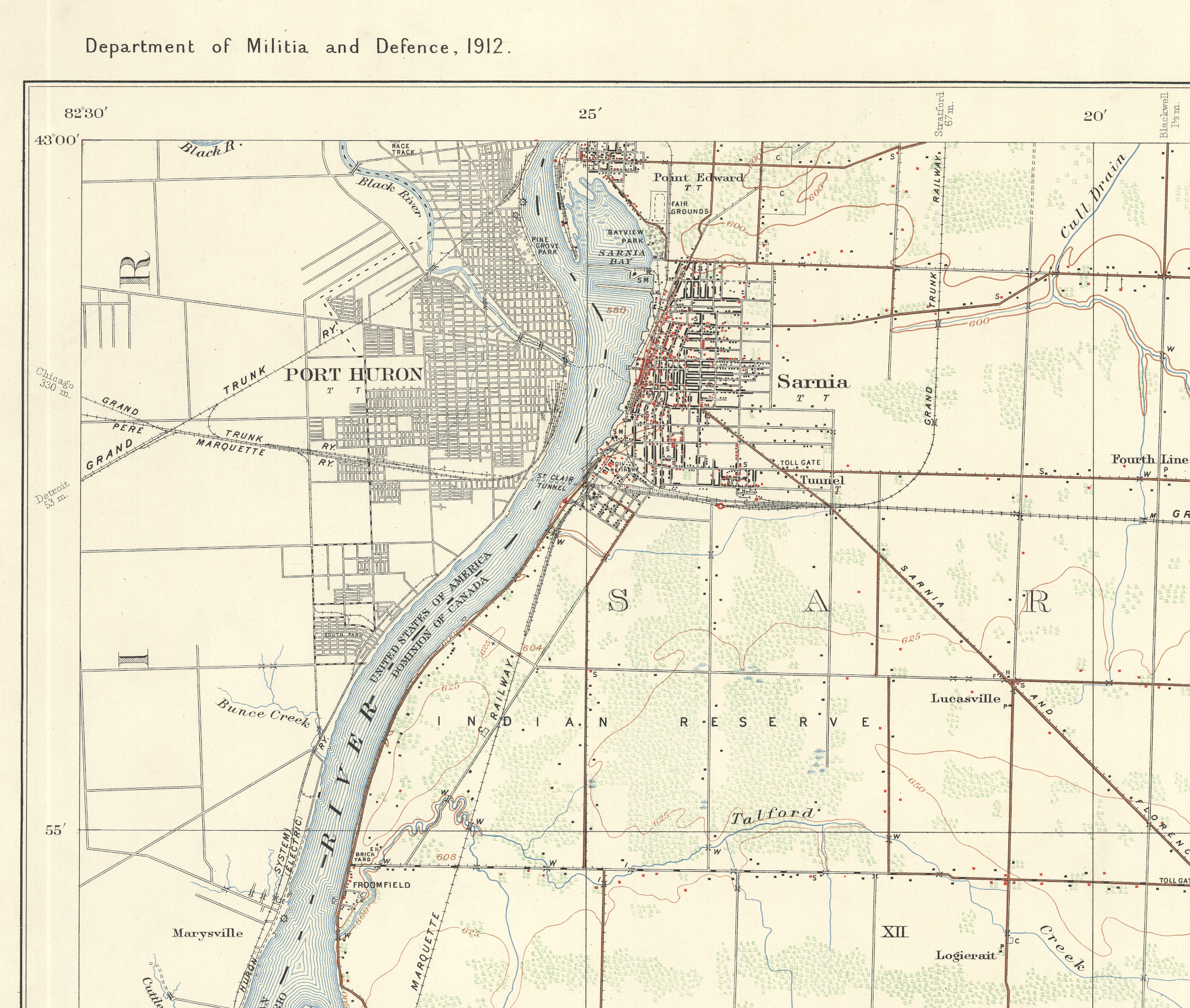 |
| 1 inch to 1 mile topographic map, Sarnia sheet; 1912 (see top left corner) from: Historical Topographical Map Digitization Project, https://ocul.on.ca/topomaps/ |
On the 1912 map above, you can see the nascent petroleum refining industry beginning in Sarnia - near the eastern portal of the tunnel.
This Militia and Defence topographic map includes important tactical features and historical detail. A brown road is 'metalled', that is, it has an all-weather surface (Latin: derived from a mine) - so tar, asphalt, concrete, etc. Half-hatching along the roads indicates a telegraph or telephone line.
Red buildings are stone or concrete. So anything round is probably a roundhouse (I see two). Black buildings are wood ... often round black buildings may be railway water tanks.
T (with serifs) is a telegraph office. But a T (sans serifs) is a telephone office. As railways had telegraph facilities which are not marked, one assumes they must mean telecom exchange buildings - eg., filled with operators sitting on stools at manual switchboards.
H is a hotel or tavern. S is a school. SM is a sawmill. GM is a grist mill.
Bridges are M (stone) I (iron) or W (wood).
Churches with a spires are buildings with an attached cross ... the attached cross showing the side of the building on which the spire is located. ... Spires being useful for reconnaissance of a distant enemy, signalling ... and directing artillery fire. C is cemetery.
* * *
The Wild Card ...
There are some fun-looking construction catwalks along the face of the dam ...
Sometimes people have trouble telling the Hoover Dam and the Boulder Dam apart.
Salt Lake City, Utah ... to Riverside California (near San Bernardino) would have been perhaps a 700-750 mile drive. This was long before interstate highways and early in the era of the private automobile.
 |
detail from: U.S. Department of the Interior, Bureau of Reclamation, 1946; from The Colorado River, A Natural Menace Becomes a National Resource ... at ... alabamamaps.ua.edu/historicalmaps |
The railroad branch line joining Las Vegas with the future dam site was built in 1930. Prohibition was still on - but 'off and on' in Vegas. Las Vegas made casino gambling legal in 1931, as well as granting divorces after a 6 week residency period. (In typical fashion, rather than Vegas, Canadians had to go to the Senate of Canada for their divorces.)
On this map from 1946, the railroad shown is labelled as the Los Angeles and Salt Lake Railroad - eventually part of Union Pacific Railroad.
Construction of the dam started in 1931 with the dam (but not the powerhouse) being completed/opened in 1935 to coincide with a tour of the American west by President Franklin D Roosevelt (in office 1933-1945). FDR's New Deal(s) would become essential in offering hope to citizens in the depths of the Great Depression.
('In many ways, Herbert Hoover was the American RB Bennett' ... discuss ...)
For reasons one might assume were intended to promote the idea of positive, sweeping change the Hoover Dam project was renamed the Boulder Dam - a name it had from 1933 until 1947. Congress then re-renamed it the Hoover Dam. So, there!
It seems that many efforts 'to make deserts bloom' do not end happily for everyone involved for all time. While the hydro-electricity was handy to keep the neon of Las Vegas lit, the principal goal (as shown on the map above) was to see how much water could be pumped out of the Lake Mead Reservoir of the Colorado River 'to serve man' ... as they always used to say.