Showing posts with label Winnipeg. Show all posts

26 April 2024

Fort Garry Gate & CNR/GTP Tracks at the Forks, Postcards x5

Modern historical interpretation finally gives us a clue! 

Virtually nothing is left of the former fur-trading 'district headquarters'. The last enduring fragment of the old fort has stood there as 'something, something old' for almost 150 years. One could collect postcards down through the ages (see below) but still not understand what one was looking at.

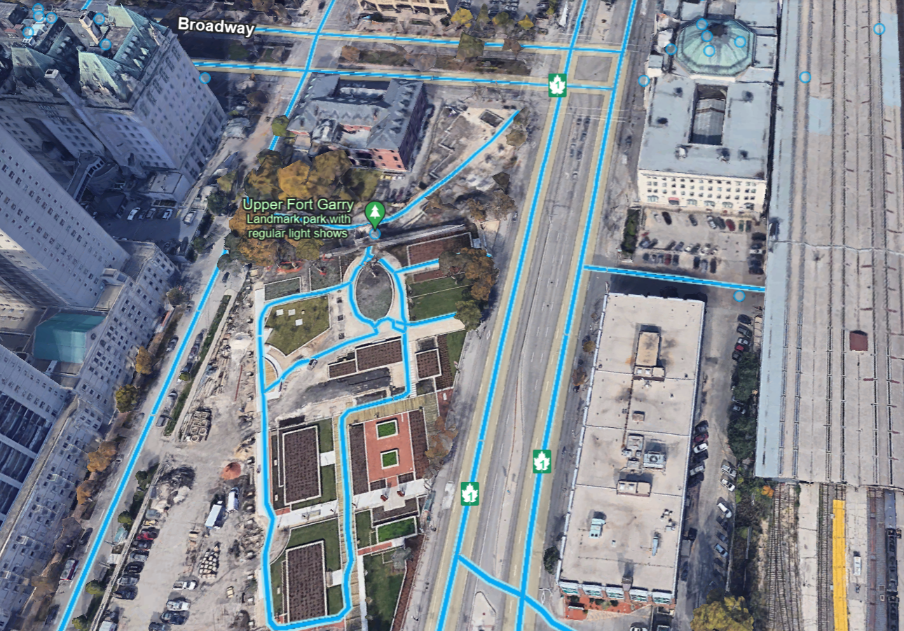
Without puzzling over postcards or going through history books or university map sites, you can begin to guess where Fort Garry once was ... just by looking at the image below. 

Your starting point for this voyage of discovery is the surviving fort gate, located where the national-parks-evoking fir tree image points.

from: Google Earth

Nicholas Garry was an unmarried London-based director on the Hudson's Bay Company Committee (i.e. board of directors) ... who volunteered to travel to Canada ... to communicate the news that the North West Company and the Hudson's Bay Company would cease their trading rivalry and violence ... and consolidate as one organization. 

This combination was forced by the British government which was 'tired of you two kids fighting in the back seat!'

Simon McGillivray was appointed to represent the North West Company on the same mission. Garry and McGillivray were breaking this news primarily to gatherings of the wintering partners as they travelled.

In July or August of 1821, they reached the Red River Colony (also known as the Selkirk Settlement) and then it was off to Norway House. 

In 1822, the newly-established HBC fort 'at the Red River Colony' was named Fort Garry in honour of Nicholas Garry's work and visit during the previous year.

*  *  *

While the circa Edwardian postcard scene may be 'English-looking' ... 

maybe that's not exactly what we should be aiming for when considering this artifact of Canadian history.

The other building was the home of the Manitoba Club before a new building opened in 1905.

*  *  *

from: Canada's Five Centuries; W Kaye Lamb; 1971; McGraw-Hill.

The source 4 inch by 5 inch image above depicts Fort Garry as it would have appeared in 1867.

You can see our still-surviving cube-shaped north gate of Fort Garry ... centred on the left end of the fort. In the foreground is the Assiniboine River. It empties into the Red River. The Red is seen on the far side of the fort and flows right (south) to left (north).

The Forks was an essential commercial junction of two significant early Canadian transportation assets - the two rivers.

A TV show once pointed out that the historical grand entrance to the Taj Mahal was on the Yamuna River side - because important guests travelled by water and would be received there. The everyday 'tourist photo' of the Taj Mahal is actually of its back yard ... where Shah Jahān would keep things like his propane barbeque, compost bin, etc.

Similarly, the image above shows steamboats, York boats, canoes, wagons and carts working out of The Forks-side gate ... which is not the gate which was preserved. It seems likely that touring fur trade big shots would have arrived by water at the south gate.

In 1822, through the governor's north gate, he could travel by road to ... the Red River Colony ... and return ... and that's about it.

*  *  *

from: Manitoba Historical Maps;   https://www.flickr.com/photos/manitobamaps/3170781512/ 

The image above suffered some kind of computer glitch when it was being digitalized for the internet, but you can still read all the labels. 

*  *  *

from: Historical Atlas of Manitoba; Warkentin & Ruggles; 1970; Historical & Scientific Society of Manitoba.

Above, the North West Company's name for its installation at The Forks was Fort Gibraltar. On this very flat region of the Prairies ... canoes would approach the fort at water level along the eroded river valleys. From that perspective, the NW Company's post probably took on a Gibraltar-like appearance.

*  *  *

from: Historical Atlas of Manitoba; Warkentin & Ruggles; 1970; Historical & Scientific Society of Manitoba.

With Fort Garry (the future site of Winnipeg) in the centre of the map ... and Fort William (part of the future Thunder Bay) in the lower right corner ... you can see the river systems and lakes which facilitated commerce and travel early in Canadian history. Weather permitting.

After meeting the wintering partners at Fort William ... Nicholas Garry, Simon McGillivray, paddlers, et al travelled ... across Lake of the Woods, down the Winnipeg River, across part of Lake Winnipeg, and up the Red River ... to reach the Red River Colony ... (and next year's Fort 'Garry' - shhh, it's a surprise!)

*  *  *


If this card is indeed from 1924 ... they didn't wait long to ensure the postcard said CNR instead of Grand Trunk Pacific Railway Fort Garry Hotel.

Covered in fuzz, here is the fort's back door - again - as it would have appeared from inside the fort.


*  *  *


*  *  *


On the horizon you can see the Manitoba Legislature at the left, and the Fort Garry Hotel at the right.

*  *  *


Part of an interesting map from 1911 appears below - back then, the only 'CNR' was the private Canadian Northern Railway.

The quoted link under the image will take you straight to the high-resolution image, which is full of railway history.

from: Manitoba Historical Maps;  https://www.flickr.com/photos/manitobamaps/2825450318/


01 December 2023

The Countess of Dufferin, Postcards x5


At the top of the postmark, you can barely make out GT Ry. According to its serial number, the postcard below was published in 1910 - although the photo may have been taken earlier. Lords Mills is northeast of Brockville. 

The postcards below all show the CPR station at Winnipeg.

It is interesting to see how postcards were used for everyday messages. A telegram would be more cumbersome to arrange and costlier to send. A long distance telephone call would have been extremely expensive - to the point of being unthinkable. I marvel at how postcards used locally for routine messages often showed photo subjects which were so far away.

Finding the correct name for the historical writing utensil used below was interesting. 

When roller bearings were developed, it seems that the old brass bearings were retro-actively renamed plain bearings - prior to that, they were probably just called ... 'bearings' ... maybe 'brasses'. 

... Similarly, a fountain pen - an instrument composed of a nib fed from a refillable reservoir (or a disposable plastic cartridge) was a new technology which superseded a ... 'pen'. 

... The 'pen' was 'a stick with a nib' which held ink by surface tension. During a writing session, it was continually dipped into a bottle of ink. Before that, people would cut a large feather's shaft (the quill or calamus) on an angle and dip that into a bottle of ink.

This first type of mass-produced 'pen' with a metal nib - as used below - is now often referred to as a calligraphy dip pen.


When we were taught cursive writing in Montreal in the mid-1960s (around Grade 4), we used fountain pens with plastic ink cartridges. Pressing down on the pen would spread the tines of the nib to make a thicker line. Often downstrokes are wide and lateral strokes are thin. Ballpoint pens were a great improvement and a great relief - once we had completed our fountain pen phase!

I don't remember seeing a 'pen' being used like this on a postcard before. You can see how Mabel is in a rush to complete her message. In her phrase 'short of men at the shops' ... her nib dries out and she goes back with a freshly-dipped pen to cross the 't' in 'short'. 

Communicating this kind of haste through calligraphy must violate all kinds of Victorian-era rules of etiquette - but the stamp shows King Edward VII, so get over it! (He died during the same year the postcard was sent - in May of 1910.) 

Mabel (the sender) has probably been told to send this message by Jack. She is probably not happy about being caught in the middle. Gressie's father evidently wants his house painted now. I think Gressie is an old Scottish familiar version of 'Grace' ... from what I could find.

*  *  *

In every way, the underlying subject of this post was the epitome of Victorian grace. 

Her spouse would probably generously pay someone to paint your house..

But first, some postcards showing a locomotive ...


The very small circular marking at the top-centre indicates this card was printed in Cambridge, Massachusetts.

*  *  *


*  *  *


*  *  *


*  *  *


from: Manitoba Historical Atlas; Warkentin & Ruggles; 1970; Historical & Scientific Society of Manitoba.

The underlying events of this post take place (1876, 1877) when the Canadian Pacific Railway (often then referred to as the Canada Pacific Railway) was still a government enterprise. Canadian politics had been rocked by the Pacific Scandal. Sir John A Macdonald had lost power in 1873 and would not return as Prime Minister until 1878. 

Notice that the map above shows the CPR avoiding Cactus Plain and 'extensive plains, more or less barren'. This would be Palliser's Triangle in the southwest corner of the map.

*  *  *

The Earl of Dufferin - the Governor General - and his spouse (the former Hariot Georgina Rowan-Hamilton) 'Hariot Dufferin' travelled to British Columbia in 1876. The caricature below summarizes the events and agitation against the federal government as the promised Pacific railway had still not been built during the regime of Prime Minister Alexander Mackenzie. 

Dufferin was a skilled and accomplished diplomat and helped to calm the waters. He was really an exceptional public servant who put service to Canada first. In a larger context, he was serving the British Empire and his future assignments reflected this unselfish devotion to duty. 


from: A Caricature History of Canadian Politics; JW Bengough; 1886; The Grip (reprint 1974).

Back in those days, wooden arches decorated with greenery, and messages of welcome in large letters, were often built over the main streets on which visiting dignitaries would pass. This was frequently done when heirs to the throne visited Canadian cities. In this particular case, Frame 11 shows 'Vancouver puts up an arch' ... and this wording is what the Governor General Lord Dufferin was confronted with when he came to visit and make peace.

*  *  *

In 1877, Dufferin and his spouse travelled to visit Manitoba and the surrounding area. To read through the account of their trip, one is impressed with the inconveniences and discomfort they met on these trips through wilderness Canada. Representing more than themselves, they consistently rose to the occasion and put service before self.

The people they met, the travel, the settlements, the isolation, the food, and the customs described during this type of old pre-railway cross-Canada trip really give one a sense of what the Canadian wilderness had been like for hundreds of years. And how it was being changed forever. 

Hariot Dufferin's letters home, including her account of the Manitoba trip, were published years later in 1891 as a book. You can get an idea of how this couple approached their duty in the following few pages.

Page 365 and Page 367 can be considered primary historical documents for their description of Hariot Dufferin's contacts with CPR hardware. 

It is very difficult to keep up with the dates of all the title changes these two experienced during their careers. Apparently, a marchioness is the spouse of a marquess. The anglicized word is pronounced something like 'Martian-ness'.


Here is the archive.org link to Hariot Dufferin's account of her travels if you are interested:

My Canadian journal, 1872-8 : extracts from my letters home written while Lord Dufferin was Governor-General

28 October 2022

Winnipeg - Postcards of Stations


There was never a Union Station in Winnipeg - the CP and CN were always separate!

... a decade or so ago, that's how an expert stranger from The Internet set me straight.

He was both right and wrong at the same time, I think.


There are blog posts which take weeks to research or prepare ... to the point that they cause physical pain from repetitive strain. And there are lazy posts where one just shows a few postcards. 

... As one ages, one develops the wisdom to do more and more lazy posts where the artifacts are allowed to speak for themselves. Finally, without paying for a 'large' website, one can now have the satisfaction of posting the highest resolution image that anyone would ever want to see ... or to save for future reference or sharing.

Contributing to the overall body of historical resources which are available to all is still a rewarding pastime. As we all well know, things on the internet probably will be there for a long, long time.

Recently, I was excited to discover two image 'artifacts' on Eric's website regarding where the Canadian Northern Railway station in Portage la Prairie had been located. I've had a photo of the station with a newly outshopped steam locomotive for years. However, this location trivia was sort of my elusive Holy Grail - I could never, ever find the answer anywhere. Some even questioned the idea that Portage had 'other' stations beyond the two buildings which still exist in 2022.

Hopefully, images like these will someday provide a similar answer to someone with a long-standing curiosity about an aspect of historical trivia. 


No publisher's identification. Undated, unused.


Chas. A Meyers & Co. Undated, unused.


Advance Culture and Post Card Depot, 537 Main Street, Winnipeg. Mailed to Youngstown, Ohio in 1906. 

The old map below shows the general location of railway facilities.
Count up all the different railway companies if you want.
Blue lines represent streetcar routes.

from: Government of Canada Atlas, 1915.


Northern Photo Services. Undated, unused.
Postcard caption: "Union Station situated on Main Street just south of Portage and Main in Winnipeg."


Goldin & Co, Winnipeg from CNR photo. Mailed to Hamilton, Ontario, July 1960.

Above: The station building can be seen beyond the trainsheds and under the postmark stain.


Valentine Edy Company, Winnipeg. Unused, undated. Printed USA.


Valentine & Sons United Publishing, Toronto and Winnipeg. Undated, unused. Printed: USA. (card published circa 1912)


Valentine & Sons Publishing, Montreal, Toronto, Winnipeg. Printed: Great Britain. (card published circa 1913)

Notice the Canadian Northern style (the style later adopted by Canadian National) number plate on the 1125.


Thank you to Jim Christie for sending along 

this excellent contemporary engineering and construction record 

for the Winnipeg Union Station.

Winnipeg's New Union Passenger Depot, 1910


07 January 2022

1904 Western Canada Postcards, Maps

Here are a few maps from circa 1904 showing railways in North America, in the provinces and territories of western Canada, and in Manitoba & Winnipeg. Also included are some western postcards of the same period. 

The originals of the larger map images are about 6 x 8 inches. This small but high quality British atlas shows the world before World War I - so the maps of Europe and Africa are quite interesting to contrast with all the changes which occurred since then. As only telegraph messages moved instantly across the ocean back then, you can imagine how cumbersome and difficult it must have been to update an atlas showing all the rapidly-evolving changes across North America.


This hand-coloured, undated, unmailed postcard was published by Stedman Brothers of Brantford. 
It was printed in Germany. Germany had most of the world's market for colour postcard printing - but World War I ended their dominance.

All the maps below show railways. Roads between settlements had not developed significantly.


This postcard was produced by the Advance Culture and Post Card Depot, 537 Main Street, Winnipeg.

It was mailed to Youngstown, Ohio, but the postmark is not legible.


Finally: Oak River is 11 miles north-west of Rivers, Manitoba and was on the CPR Miniota Sub which ran from Brandon to Miniota (1967 data). 

This card has no manufacturer indicated. It was mailed from Walkerton to Greenock Ontario in 1908.


31 December 2021

Winnipeg Maps 1915, Streetcars, Interurbans


Above: A hand-coloured Valentine company postcard, no date.

*  *  *

The two following images are different sizes of the same map of Winnipeg - from the Government of Canada Atlas of 1915. 
(Original size is about 12 inches by 17 inches)
Electric railways are shown in blue.


*  *  *

The next images are from The Era of Streetcars and Interurbans in Winnipeg 1881-1955; Herbert W Blake; 1974; self-published.


Streetcar lines above. Interurban lines below.


*  *  *

More details on the Winnipeg, Selkirk and Lake Winnipeg follow from: 
The Intercity Electric Railway Industry in Canada; John F Due; 1966; University of Toronto Press.


Postcard above by Bloom Brothers, Winnipeg, hand-coloured, no date.