Showing posts with label 1870s. Show all posts

17 April 2026

Sandford Fleming - A List of Posts About Him .. & Ocean to Ocean in 1872

Pieces on Sandford Fleming before he was knighted ...

 Sandford Fleming & Time Zones - Stuck Overnight at Bundoran in 1876!

1881 - Sandford Fleming Rides in a Gondola

Time Zones for Railways in North America

International Meridian Conference, 1884 - Indefatigable Sandford Fleming

*  *  *

The Fleming Expedition of 1872 - from Halifax to Victoria

Fleming was a civil engineer and surveyor. In 1872, he was Engineer-in-Chief of the Intercolonial and he had also been offered the post of chief engineer of the Canadian Pacific Railway survey. 

Back in 1862, Fleming had presented the government with the plan for an ocean to ocean railway. A decade later, we find Fleming looking for a route for the railway to the Pacific. Below is a photo of some of the people embarking on that expedition.

Sitting: Frank Fleming, Mrs. Fleming, Mrs. Moren, Dr. Arthur Moren.
Standing: Rev. G.M. Grant, Sandford Fleming, Col. Robertson Ross
Library and Archives Canada / C-002788

Sitting: 

Frank Fleming was Sandford Fleming's son. 

Dr Arthur Moren was from Halifax and the medical officer for the trip. 

Standing: 

Rev GM Grant was born in Pictou, NS and was educated at Glasgow University - he chose to return to Canada to conduct his ministry and was the Secretary for the group. Afterwards, he was the author of Ocean to Ocean. 

Colonel Patrick Robertson-Ross, Adjutant-General of the Canadian Militia (the Canadian 'army') joined the group between Toronto and Fort Garry.

The complete list of participants is shown below. At certain points personnel changed. Fleming sometimes dispatched members to explore alternate routes. 

*  *  *

Ocean to Ocean, Grant's skilfully-written account of the expedition, was widely read both in Canada and in the United Kingdom. It drummed up interest in the former Hudson's Bay Company lands of the Northwest and presented the railway as an essential element of Canadian nation building. 

... It describes life and travel in the west before the introduction of mechanized transportation - the familiar CPR-settlement era. Grant's record of the feats of the highly-skilled guides from Kahnawake, including their canoe competitions and 'games' is particularly interesting.

Also mentioned are those whom we might consider to be 'refugees' from their own lands - bands from the United States who fear the 'longknives' - the US Cavalry. These aboriginal people hope for survival and safety by crossing the British North American border. 

History is always complex and Grant foresees some of the difficult questions facing both the First Nations and Métis ... and those of European extraction ... once their cultures meet in the west. 

Grant does not dwell on aboriginal issues, however, and he does not sugarcoat ...

 As the expedition travelled during summer and late fall in Canada, the relative fierceness of the native insect population is the subject of regular documentation!

*  *  *

My copy is:

Ocean to Ocean; Reverend George M Grant; 1873; Charles E Tuttle & Co (1967 reprint).

At the end, a link to another publisher's version at archive.org is provided.
The images with a yellow tint are from archive.org. 


The map from the reprint is reproduced below.
It is not particularly easy to read, but it shows the general routes explored.


from: Ocean to Ocean; Rev George M Grant; 1873; Charles E Tuttle & Co (reprint). 

*  *  *

The Itinerary of the Expedition


*  *  *

"Bonus Content"

The North-west Angle - July 29, above.

As the expedition passes this location, the Secretary - the Rev George Grant - writes ...

from: Ocean to Ocean; Rev George M Grant; 1873; Charles E Tuttle & Co (reprint).


As the border might have been ...

from: Historical Atlas of Manitoba; Warkentin & Ruggles; 1970; Historical & Scientific Society of Manitoba.

This is the JS Dennis map of 1869.
You can see the Hudson's Bay Company post at the South-west Angle of Lake of the Woods.

The continuation (above) of the 49th Parallel to the South-west Angle of Lake of the Woods would have been logical. 

*  *  *

However, the Mitchell Map was cobbled together from maps compiled by an American-British physician-botanist ... originally from Virginia ... trying out yet another hobby after moving to Britain. 

This was John Mitchell (1711-1768). His work was sponsored by George Montagu-Dunk, 2nd Earl of Halifax (yes, 'that Halifax') and published in 1755. Halifax had complex imperial motivations. 

Hopefully, it was to no one's surprise that ... a map made at such a distance did not accurately fix the true location of the origin of the Mississippi River. It was this inaccuracy which indirectly led to the North-west Angle error (seen below). After several international armed conflicts, treaties, and conferences ... this error became the official boundary. 

There were worse historical boundary injustices inflicted on Canada on our behalf by the Colonial Office (and its many antecedents) as it bargained with the United States. Please, let's not be bitter. 

The 'Pene-exclave' of water-locked American isolation south of Angle Inlet (below) is the only part of the contiguous United States north of the 49th Parallel. A local plaque attributes this quirk of the border to the skilled negotiations of Benjamin Franklin.

*  *  *

Today's Canada - US Border at Lake of the Woods
... at the North-west Angle (Northwest Point)

from: Google Maps 2026.

*  *  *

Having discussed the North-west Angle, the party continues west from 'Winnipeg'.


 Here is the link to the book at archive.org


end

07 March 2026

Sandford Fleming & Time Zones - Stuck Overnight at Bundoran in 1876!


Spot the points of ignorance displayed by a brilliant mathematician and astronomer. 

This comment was returned by Sir George Biddell Airy, Astronomer Royal (he held this office: 1835-1881), Greenwich, 18 June 1879 ... regarding one of Fleming's papers from 1878-79 which had been forwarded via the Governor General (Marquis of Lorne) to the British government for distribution and comment. 

In particular, look at his suggestion regarding schedules and timekeeping for transcontinental trains in the United States.


A train leaves New York using local solar time. 
Another train leaves San Francisco using local solar time. 

A dispatcher writes a meet order. 

Where will the two trains collide?

This was not Airy's only railway-related error!

Astronomer Royal Airy was consulted by the North British Railway to calculate the wind pressures to be expected on the Tay Bridge. He calculated a maximum wind pressure of 10 pounds per square foot which was much lower than that produced during severe storms. 

In fact, 56 pounds per square foot later became the assumed maximum pressure ... before that value was multiplied by 4 to provide a design margin of safety. 

Myriad miscalculations and errors by many contributors led to the Tay Bridge Disaster on 28 December 1879. It occurred six months after Airy's comments on Fleming's paper (above) .

In spite of this kind of negative feedback, Fleming persisted in his efforts. 

*  *  *

There are a number of postcards on the internet showing an early version of the small Bundoran, Ireland station. It was probably in that building where Sandford Fleming resolved (overnight) to do something about the way time was being reckoned. Everywhere.

Fleming's biographies from 1915 and 2000 both spell the town 'Bandoran' but I've found no evidence anywhere that it was ever spelled that way. Perhaps Fleming misspelled it in his notebook at the time. 

So let's look at a map to better understand the incident which contributed to Fleming's devotion to networking and campaigning ... to establish in the imperial and western world ... a new system of time zones.

This post looks at the details of Fleming's trip, and also excerpts from his first paper on the subject.

from: Sandford Fleming, Empire Builder; Lawrence J Burpee; 1915; Oxford.  archive.org

An image of Fleming (1827-1915) 16 years before his determination to change time.
The author of his (2000) biography stated that Fleming essentially dictated his 1915 biography to the writer.

*  *  *

from: Handy Reference Atlas of the World; JG Bartholomew; 1904; John Walker & Co.

If you find Londonderry at the top of the map, Enniskillen and Bundoran Jct are to its south. If you head for the west coast, you'll find Bundoran. These were the geographical limits of his trip in the story below.

*  *  *

From his 1915 biography, here is the story of his overnight stranding in a small country station.

from: Sandford Fleming, Empire Builder; Lawrence J Burpee; 1915; Oxford.  archive.org

Below is a Bianconi car, also known as a public car. 

from: Charles Bianconi, a biography; 1786-1875; Mrs Morgan O'Connell (his daughter); Chapman & Hall. archive.org

For a former surveyor, and someone who had just travelled 'Ocean to Ocean' in 1872, travelling by public car would not have been a great hardship.


from: Citizen's Atlas of the World; John Bartholomew; 1924; Geographical Institute, Edinburgh.

On the (1924) map above ...
  • Londonderry is in the top right corner. 
  • Enniskillen (60 miles by rail) is near the centre, bottom. 
  • Manor Hamilton (30 miles by public car) is at the bottom, near the west coast and Sligo. 
  • Killennumery (8 miles by private carriage) exists only as a cemetery today and is not shown on the map above. It was southeast of Manor Hamilton. 

Almost 50 years later (the publishing date of map above) there was no direct railway connection along the route that Fleming took northbound, Killennumery to Bundoran. 

Bundoran is at the first bit of pink on the west coast. With the low mountains, at least his late-afternoon horse-drawn trip would have been scenic. In some ways it reminds me of the hill topography around Lake Superior.

*  *  *

If Fleming had travelled 18 years later, he would have found a luxury railway hotel at Bundoran in which to ruminate - instead of a small stone station building.

from: Picturesque Donegal; 1908; Great Northern Railway (Ireland).

Opened in 1894, the hotel was designed by the railway company's architect Thomas Drew, and constructed entirely of concrete - instead of wood - to better survive the humid climate. Bundoran was styled as the 'The Brighton of Ireland'. 

The hotel still exists today - nicely-restored and maintained. See: The Great Northern Hotel.

The railway line was originally built as the Enniskillen and Bundoran in 1866. The Great Northern Railway (Ireland) took over and began operating the line in 1876. 

Perhaps the change of management/new listing led to some problem with the printing of the departure times - the corporate takeover happening the same year in which Fleming travelled.

As the bare minimum, in 1876 Fleming had hoped that humans could develop the capacity to use a 24-hour clock rather than the AM/PM 12 hour clock ...

*  *  *

July 1922: Almost nothing has changed! 

from: Bradshaw's Railway Guide; July 1922; Henry Blacklock & Co (reprint)

Above are the mainline trains. 'Weekdays' during this era were Monday-Saturday.

AM and PM are marked as mrn or aft, respectively. In one case I noticed on another page - where an entire schedule was completed during the 'noon hour' - the abbreviation non is used.

The particular listing which Fleming would have used: Bundoran has trains departing for Londonderry (left half of the sheet, read down) 630 mrn, 1125 mrn, and 530 aft. (Generally, trains were 'Up' toward a major city or capital ... or 'Down' from a major city or capital. I assume that Dublin was the important city in this case.)

... We can imagine that Fleming would be quite discouraged, after his 1876 experience, to see that the world still had not learned to write/read his train times as 0630, 1125 and 1730 to avoid confusion and errors. 

*  *  *

Below For the sake of local history, here are the 'all stops locals' between Bundoran Junction and Bundoran with abridged timetables showing only main cities. 

from: Bradshaw's Railway Guide; July 1922; Henry Blacklock & Co (reprint)

screencap from: The Great Northern Railway (Ireland); Edward Patterson; 1962, 2003; Oakwood Press. archive.org

Above: The improved Bundoran station offered a trainshed to protect the affluent Great Northern passengers drawn to the resort. There is a 'Station Road' in Bundoran today but no trace of the railway line or its buildings that I could find.

The station building was located where the library and local council offices now stand. The government of Northern Ireland cut off the sections of railway which crossed the border on 1 October 1957. The station was demolished after this change.

*  *  *

The Railways Lead the Way

As would happen in North America, the railway system of Britain began using standard time ...

Most British railways had adopted Greenwich Mean Time as their standard by 1848. 

As a result, the general public began to follow this standard. 

The Royal Observatory began broadcasting time signals by telegraph in 1852. 

GMT was legally recognized as the standard time for Britain in 1880.

*  *  *

Was Fleming Driven Mad at Bundoran?

Looking at short excerpts from Fleming's first paper on time ...


1876: His first paper is produced and circulated privately among selected colleagues 

... to avoid any in-public pranging of his novel system.


Here is some interesting Canadian history ...
(It's always been about 'you', Toronto!)

To people accustomed to a 'GMT' standard, or UTC, or 'military time' or Zulu time, the model is not hard to imagine. Fleming tries to avoid the appearance of favouritism by not anchoring his prime meridian to Britain at Greenwich. There were 11 or so other prime meridians used by other countries at the time and he was aware that too much nationalism would defeat the whole effort to develop a worldwide standard. 


Fleming's hour hand provides travellers, etc, with a graphic representation of the sun's apparent motion around the earth. So people constantly moving or thinking about different time zones could purchase a 24-hour chronometer which would key to the appropriate time zone. 

Although ... someone would have to engineer that new 24-hour timepiece.


On a few occasions, I attempted to fully understand the table above. There are perhaps some local idiosyncrasies of their historical local British time at the top of the chart? You get the general idea, at least.


Fleming is kind of struggling with a way to graphically portray the concept he is thinking of. As you'll see, his subsequent papers are less concerned about over-engineered physical technology. 

Instead, his ideas find support from other diverse professions which are also experiencing difficulties created by fast, modern worldwide telegraphic and railroad connectedness. 

In contrast, the reckoning of time had never slipped into its sandals and walked away from the high noon shadow on a sundial.


A link to the whole paper at archive.org


01 December 2023

The Countess of Dufferin, Postcards x5


At the top of the postmark, you can barely make out GT Ry. According to its serial number, the postcard below was published in 1910 - although the photo may have been taken earlier. Lords Mills is northeast of Brockville. 

The postcards below all show the CPR station at Winnipeg.

It is interesting to see how postcards were used for everyday messages. A telegram would be more cumbersome to arrange and costlier to send. A long distance telephone call would have been extremely expensive - to the point of being unthinkable. I marvel at how postcards used locally for routine messages often showed photo subjects which were so far away.

Finding the correct name for the historical writing utensil used below was interesting. 

When roller bearings were developed, it seems that the old brass bearings were retro-actively renamed plain bearings - prior to that, they were probably just called ... 'bearings' ... maybe 'brasses'. 

... Similarly, a fountain pen - an instrument composed of a nib fed from a refillable reservoir (or a disposable plastic cartridge) was a new technology which superseded a ... 'pen'. 

... The 'pen' was 'a stick with a nib' which held ink by surface tension. During a writing session, it was continually dipped into a bottle of ink. Before that, people would cut a large feather's shaft (the quill or calamus) on an angle and dip that into a bottle of ink.

This first type of mass-produced 'pen' with a metal nib - as used below - is now often referred to as a calligraphy dip pen.


When we were taught cursive writing in Montreal in the mid-1960s (around Grade 4), we used fountain pens with plastic ink cartridges. Pressing down on the pen would spread the tines of the nib to make a thicker line. Often downstrokes are wide and lateral strokes are thin. Ballpoint pens were a great improvement and a great relief - once we had completed our fountain pen phase!

I don't remember seeing a 'pen' being used like this on a postcard before. You can see how Mabel is in a rush to complete her message. In her phrase 'short of men at the shops' ... her nib dries out and she goes back with a freshly-dipped pen to cross the 't' in 'short'. 

Communicating this kind of haste through calligraphy must violate all kinds of Victorian-era rules of etiquette - but the stamp shows King Edward VII, so get over it! (He died during the same year the postcard was sent - in May of 1910.) 

Mabel (the sender) has probably been told to send this message by Jack. She is probably not happy about being caught in the middle. Gressie's father evidently wants his house painted now. I think Gressie is an old Scottish familiar version of 'Grace' ... from what I could find.

*  *  *

In every way, the underlying subject of this post was the epitome of Victorian grace. 

Her spouse would probably generously pay someone to paint your house..

But first, some postcards showing a locomotive ...


The very small circular marking at the top-centre indicates this card was printed in Cambridge, Massachusetts.

*  *  *


*  *  *


*  *  *


*  *  *


from: Manitoba Historical Atlas; Warkentin & Ruggles; 1970; Historical & Scientific Society of Manitoba.

The underlying events of this post take place (1876, 1877) when the Canadian Pacific Railway (often then referred to as the Canada Pacific Railway) was still a government enterprise. Canadian politics had been rocked by the Pacific Scandal. Sir John A Macdonald had lost power in 1873 and would not return as Prime Minister until 1878. 

Notice that the map above shows the CPR avoiding Cactus Plain and 'extensive plains, more or less barren'. This would be Palliser's Triangle in the southwest corner of the map.

*  *  *

The Earl of Dufferin - the Governor General - and his spouse (the former Hariot Georgina Rowan-Hamilton) 'Hariot Dufferin' travelled to British Columbia in 1876. The caricature below summarizes the events and agitation against the federal government as the promised Pacific railway had still not been built during the regime of Prime Minister Alexander Mackenzie. 

Dufferin was a skilled and accomplished diplomat and helped to calm the waters. He was really an exceptional public servant who put service to Canada first. In a larger context, he was serving the British Empire and his future assignments reflected this unselfish devotion to duty. 


from: A Caricature History of Canadian Politics; JW Bengough; 1886; The Grip (reprint 1974).

Back in those days, wooden arches decorated with greenery, and messages of welcome in large letters, were often built over the main streets on which visiting dignitaries would pass. This was frequently done when heirs to the throne visited Canadian cities. In this particular case, Frame 11 shows 'Vancouver puts up an arch' ... and this wording is what the Governor General Lord Dufferin was confronted with when he came to visit and make peace.

*  *  *

In 1877, Dufferin and his spouse travelled to visit Manitoba and the surrounding area. To read through the account of their trip, one is impressed with the inconveniences and discomfort they met on these trips through wilderness Canada. Representing more than themselves, they consistently rose to the occasion and put service before self.

The people they met, the travel, the settlements, the isolation, the food, and the customs described during this type of old pre-railway cross-Canada trip really give one a sense of what the Canadian wilderness had been like for hundreds of years. And how it was being changed forever. 

Hariot Dufferin's letters home, including her account of the Manitoba trip, were published years later in 1891 as a book. You can get an idea of how this couple approached their duty in the following few pages.

Page 365 and Page 367 can be considered primary historical documents for their description of Hariot Dufferin's contacts with CPR hardware. 

It is very difficult to keep up with the dates of all the title changes these two experienced during their careers. Apparently, a marchioness is the spouse of a marquess. The anglicized word is pronounced something like 'Martian-ness'.


Here is the archive.org link to Hariot Dufferin's account of her travels if you are interested:

My Canadian journal, 1872-8 : extracts from my letters home written while Lord Dufferin was Governor-General


07 July 2023

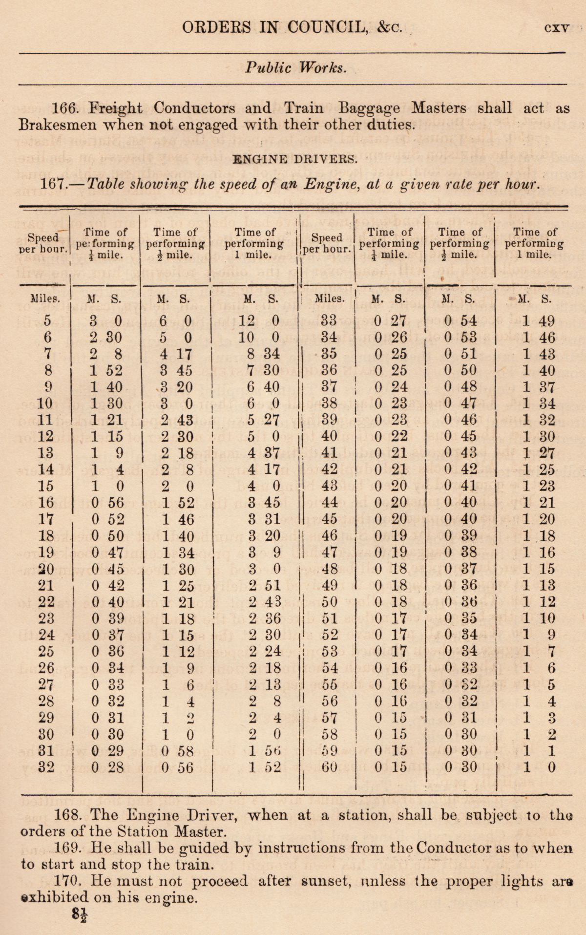
Intercolonial Railway 1877 An Early Railway Rulebook

When the country of Canada was 10 years old, this book of Government Statutes and Orders in Council was printed. In it, one can find a fairly complete and detailed description of how early Canadian railway operations were standardized - at least for this well-engineered, well-built and expensive railway which was owned by the Government of Canada.

Comparing, as we like to do with the Americans, the effort to develop national 'best practices' for American railroad operating rules began when the Uniform Train Rules and Rules for the Movement of Trains by Telegraphic Orders was approved as the first authorized 'Standard Code' by the General Time Convention of the United States in July 1889. 

The aptly named Intercolonial Railway was federal project designed to help meet the demands of some of British North America's maritime colonies - as a condition of them agreeing to join the Canadian confederation.


Above, is the title page of the ragged and dusty 300-page, 146 year old 'law book'.

*  *  *

Below, is a 'more recent' reference from 1887 which maps out the Intercolonial and its operations.

from Travellers' Official Guide, December 1887.

from: Travellers' Official Guide, December 1887.
*  *  *

This is the second time I have posted these rules to the internet because of their historical value. About 20 years ago, I typed them out in full using the Netscape HTML editor because free internet websites were very limited in their size. 

'Oh, it was the good old days of the internet! ...'

To be more illustrative, about eight copies of the Intercolonial map (above) would have used up all of my 'free' website room. And that's why I typed all the rules out. They are still 'out there' - stored somewhere beyond my control on a Google server. Google kindly sends me monthly reports on traffic and the top keyword searches which lead people to my old website.

... Span the world, you tiny, efficient HTML characters of the original Rolly Martin Country!

*  *  *

The 1877 Intercolonial Railway rules begin below:


Note: The 'brakesmen' apply hand brakes.


Rule 33. Most equipment had no compressed air train lines (but Rule 175 indicates some did). At least one serious loss of life incident occurred in Canada (February 28, 1874 on a Great Western Railway train operating between London and Komoka) when a fire started in the wooden coaches and the cord failed to work ... and the engine crew was apparently not looking back regularly to observe their train.

Here is an earlier illustrated article on the development of this important technology:


from: Summer Tours and Excursions on the Intercolonial Railway, 1894. from archive.org


Rule 119. You can see all the supplies and equipment needed to maintain, cool and repair defective 'plain' bearings. Also, 6 Links and 6 Pins ... the coupler knuckles of their day.


Rule 121. Telescoping of cars into wooden coaches in the event of an accident was a significant hazard ... as were overturned wood/coke/coal stoves and kerosene lighting appliances.  

Rule 122. In the event of a link coupler breaking while ascending a grade on a non-air-brake consist ... you can imagine that it would be important to have someone who was readily aware of the situation, with an operating handbrake at the 'headend' of the reversing, descending cut of runaway cars. 


from: Souvenir of the Intercolonial Railway, 1896. archive.org

The seemingly tiny locomotive can pull all of those coaches because most of them are probably wooden.


Rule 176. Tallow kettle. Before the availability of cheap, plentiful supplies of lubricants derived from petroleum ... animal fats were used on some locomotive bearings and valves, and they were kept in a semi-liquid state in a 'kettle' on the hot locomotive backhead. As the power of locomotives increased, having 'engineered' petroleum lubricants became a necessity.


Rule 217: At a road crossing at grade, cattle guards were wooden or metal, slats or grids placed along both sides of the public road. They would also have been used at some farm crossings. The 'unsure footing' created by the guards prevented the cattle from venturing into the sometimes attractive and lush vegetation growing along the ditches between the railway right-of-way fences. 

In the past, public roads and farm crossings were often used to move livestock over railways. 

On an established farm which was split by one of the new railways ... animals might be moved between pastures, or, animals might be brought in twice a day for milking ... across a farm crossing.

Before the development of motor vehicles which could transport livestock, animals going away to a market or to a slaughterhouse ... might be driven along public roads from the farm to a settlement with a railway stock car loading ramp. 

Rule 220: Probably derails.

Rule 227: More detail than you'd ever want to know about telegraph history, and railway telegraph technology and telegraph line troubleshooting, can be found by pressing the 'radio button' at the very top of this page for the Railway Technology & Systems 04 Index ... and then scrolling down to 'T'. 

Rule 228: Engine crews often tried to make as few water stops as possible. If water was not available where it was expected to be ... the engine might have to run light (i.e. running faster and consuming less water/steam) to the next water tank. In rare, extreme cases, the fire might have to be 'dropped' to avoid damage to the boiler or a boiler explosion - probably followed by 'paperwork' to account to the Superintendent for this deviation from efficient operations.


End of the Intercolonial Railway section of the book.