Showing posts with label Intercolonial Railway. Show all posts

07 July 2023

Intercolonial Railway 1877 An Early Railway Rulebook

When the country of Canada was 10 years old, this book of Government Statutes and Orders in Council was printed. In it, one can find a fairly complete and detailed description of how early Canadian railway operations were standardized - at least for this well-engineered, well-built and expensive railway which was owned by the Government of Canada.

Comparing, as we like to do with the Americans, the effort to develop national 'best practices' for American railroad operating rules began when the Uniform Train Rules and Rules for the Movement of Trains by Telegraphic Orders was approved as the first authorized 'Standard Code' by the General Time Convention of the United States in July 1889. 

The aptly named Intercolonial Railway was federal project designed to help meet the demands of some of British North America's maritime colonies - as a condition of them agreeing to join the Canadian confederation.


Above, is the title page of the ragged and dusty 300-page, 146 year old 'law book'.

*  *  *

Below, is a 'more recent' reference from 1887 which maps out the Intercolonial and its operations.

from Travellers' Official Guide, December 1887.

from: Travellers' Official Guide, December 1887.
*  *  *

This is the second time I have posted these rules to the internet because of their historical value. About 20 years ago, I typed them out in full using the Netscape HTML editor because free internet websites were very limited in their size. 

'Oh, it was the good old days of the internet! ...'

To be more illustrative, about eight copies of the Intercolonial map (above) would have used up all of my 'free' website room. And that's why I typed all the rules out. They are still 'out there' - stored somewhere beyond my control on a Google server. Google kindly sends me monthly reports on traffic and the top keyword searches which lead people to my old website.

... Span the world, you tiny, efficient HTML characters of the original Rolly Martin Country!

*  *  *

The 1877 Intercolonial Railway rules begin below:


Note: The 'brakesmen' apply hand brakes.


Rule 33. Most equipment had no compressed air train lines (but Rule 175 indicates some did). At least one serious loss of life incident occurred in Canada (February 28, 1874 on a Great Western Railway train operating between London and Komoka) when a fire started in the wooden coaches and the cord failed to work ... and the engine crew was apparently not looking back regularly to observe their train.

Here is an earlier illustrated article on the development of this important technology:


from: Summer Tours and Excursions on the Intercolonial Railway, 1894. from archive.org


Rule 119. You can see all the supplies and equipment needed to maintain, cool and repair defective 'plain' bearings. Also, 6 Links and 6 Pins ... the coupler knuckles of their day.


Rule 121. Telescoping of cars into wooden coaches in the event of an accident was a significant hazard ... as were overturned wood/coke/coal stoves and kerosene lighting appliances.  

Rule 122. In the event of a link coupler breaking while ascending a grade on a non-air-brake consist ... you can imagine that it would be important to have someone who was readily aware of the situation, with an operating handbrake at the 'headend' of the reversing, descending cut of runaway cars. 


from: Souvenir of the Intercolonial Railway, 1896. archive.org

The seemingly tiny locomotive can pull all of those coaches because most of them are probably wooden.


Rule 176. Tallow kettle. Before the availability of cheap, plentiful supplies of lubricants derived from petroleum ... animal fats were used on some locomotive bearings and valves, and they were kept in a semi-liquid state in a 'kettle' on the hot locomotive backhead. As the power of locomotives increased, having 'engineered' petroleum lubricants became a necessity.


Rule 217: At a road crossing at grade, cattle guards were wooden or metal, slats or grids placed along both sides of the public road. They would also have been used at some farm crossings. The 'unsure footing' created by the guards prevented the cattle from venturing into the sometimes attractive and lush vegetation growing along the ditches between the railway right-of-way fences. 

In the past, public roads and farm crossings were often used to move livestock over railways. 

On an established farm which was split by one of the new railways ... animals might be moved between pastures, or, animals might be brought in twice a day for milking ... across a farm crossing.

Before the development of motor vehicles which could transport livestock, animals going away to a market or to a slaughterhouse ... might be driven along public roads from the farm to a settlement with a railway stock car loading ramp. 

Rule 220: Probably derails.

Rule 227: More detail than you'd ever want to know about telegraph history, and railway telegraph technology and telegraph line troubleshooting, can be found by pressing the 'radio button' at the very top of this page for the Railway Technology & Systems 04 Index ... and then scrolling down to 'T'. 

Rule 228: Engine crews often tried to make as few water stops as possible. If water was not available where it was expected to be ... the engine might have to run light (i.e. running faster and consuming less water/steam) to the next water tank. In rare, extreme cases, the fire might have to be 'dropped' to avoid damage to the boiler or a boiler explosion - probably followed by 'paperwork' to account to the Superintendent for this deviation from efficient operations.


End of the Intercolonial Railway section of the book.

03 December 2021

Intercolonial Railway, Locomotive Roster (1875-1910)

Always with an eye for important historical data to be kept on file, LC Gagnon saved this ICR roster from an August 1966 copy of Railroad magazine. While it represents a specialized piece of Canadian history, it could be valuable to anyone interested in this era. I have left some of the peripheral articles and ads in the scans as some of them might be of historical interest themselves (e.g. one contains the use of the term 'hoboes').

The roster was compiled by The Railway & Locomotive Historical Society, which is celebrating its 100th anniversary as I post this. 

You can see a photo of its founder and president, Charles E Fisher (also the person who contributed this roster to Railroad magazine) at the top left of the linked page. Note 03 at the bottom of the same webpage confirms this. (The link is active in 2021).

Railway & Locomotive Historical Society, Centennial Page


For this roster ...

  • The notes reference numbers form the column at the extreme right of all five pages and reach 211. 
  • The corresponding notes text appears with the numbers bracketed, for example (211), on the first two pages.


Can't get enough of the Intercolonial?

A long time ago, on an earlier website, I wrote a piece about the Intercolonial and Sandford Fleming. That whole website was capped by my ISP at 100MB - about the size of just one of the page images reproduced above. 

The webpage linked below includes my transcription of the 1876 rulebook. (Back then, green was the colour used to signal proceed with caution, and white was proceed. It also refers to keeping a prescribed number of links and pins on hand). 
The rulebook for this government railway came into being through the equivalent of an Order in Council and I found it in a book of old laws of the 'Parliament of Great Britain' - because that's how things got done back then ... Queen Victoria would review Canada's proposed laws and email them back with some funny cat videos which she thought Prime Minister Alexander Mackenzie hadn't yet seen.

It is another piece of specialized Intercolonial history, and early Canadian railroading procedures ... if you are interested ... 


Sandford Fleming & the Intercolonial Railway


29 July 2016

Halifax, Before (1900) and After (1923)


Following a previous posting on Halifax railway and harbour features around the time of the Halifax Explosion:


This post adds a few more artifacts which help to illustrate the area before and after.

from: Glimpses In and About Halifax Nova Scotia; 1900; WH Howard on archive.org
Above, Halifax as seen from George's Island c1900. Citadel Hill is the highest feature. The area of the Explosion, the Intercolonial North Street Station, and the ICR railway yards are up the harbour to the right. Notice the small-scale, ad hoc development of the waterfront and its piers.


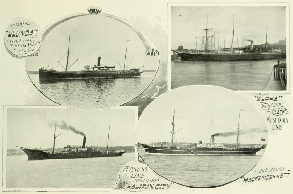
from: Glimpses In and About Halifax Nova Scotia; 1900; WH Howard on archive.org
Some typical ships in Halifax harbour c1900.
Masts on which to hoist sails are still present to supplement coal-fired steam engines.


from: Nova Scotia Illustrated, November 1895; GH Bradford. on archive.org
This interesting map identifies the smaller piers
The concentric circles show the distance from the Post Office.

from: Nova Scotia Illustrated, November 1895; GH Bradford. on archive.org
An enlargement of the map above shows the ICR facilities.


detail from: The Railways and Canada's Greatest Disaster; Douglas NW Smith; Canadian Rail No 431, Nov/Dec 1992; CRHA
The 'corrected to 1917' map from the Douglas NW Smith's article in Canadian Rail is shown above 
... and, below, rotated 180 degrees for legibility.
'X' marks the location of the Halifax Explosion.

detail from: The Railways and Canada's Greatest Disaster; Douglas NW Smith; Canadian Rail No 431, Nov/Dec 1992; CRHA

The ICR/CGR features are enlarged below.

detail from: The Railways and Canada's Greatest Disaster; Douglas NW Smith; Canadian Rail No 431, Nov/Dec 1992; CRHA

*  *  *

from: Cinders & Saltwater - The Story of Atlantic Canada's Railways; Shirley E Woods; 1992; Nimbus. 
The photo above jumps ahead in history for just a minute. 

Circa 1928, this photo shows the general arrangement at Pier 2 ... located within the 'ICR Piers' area in the map above. Canada's famous immigration location 'Pier 21' is located at the Ocean Terminals area ... out at the mouth of the harbour. Before Pier 21, this Pier 2 was the immigration pier. It was also used for departing and returning soldiers during the Great War. As Pier 2 was extensively damaged during the Explosion, this photo represents it after rebuilding.

*  *  *

During the Great War ... after the Halifax Explosion ...


After the Halifax Explosion, everyone got such a Royal Pranging - particularly the pilotage service at Halifax Harbour. 

.. As if the Great War was otherwise so perfectly conceived and efficiently organized by the Generals and Admirals! 

Then there were the lawsuits back and forth between the owners of the Imo and Mont Blanc - each claiming the other was at fault. 

... One fine morning, someone tries to do things in a hurry and it makes all kinds of paperwork for everybody - not even considering the needless loss of life at Halifax. But the whole theme and lesson of the Great War is the needless loss of life.

*  *  *

Modifications to the Halifax Ocean Terminals Plan

Jim Christie found and forwarded this article describing the post-war adaptation of the more elaborate plans made for the Halifax Ocean Terminals before the Great War. I had wondered aloud to him about the process which caused the final design to be so different and he answered my question with this article!

... With the damage to the old Halifax harbour made by the Halifax Explosion of 1917, it made sense to accelerate the development of the more spacious Halifax Ocean Terminals. The article explains the changes made to the original plans and it documents the construction completed by 1920. This was the genesis of Canada's storied Pier 21.

Two images follow the article so you see the practical compromises made to the more elaborate pre-war design.


from: The Railway Contractors; Geoffrey W Taylor; 1988; Morriss Publishing, Victoria.

I have reposted the images above (projected plan) and below (postcard view, circa 1960) so you can see how the elaborate architecture was modified due to the realities of Canada immediately after the Great War.

The images view the area from roughly the opposite directions. The drawing above is viewed from the north. The photo below was taken from the south.


*  *  *

Meanwhile ... back in the 1920s ...

Unless noted otherwise, all of the following images come from Canadian Port and Harbour Directory; 1923; Government of Canada.


Above, at the top of the map, you can see the original Intercolonial Railway tracks terminating in the Pier 2 area. 

The new Ocean Terminals (dotted outlines) and the Pier 21 area appear near tiny George's Island.


Above, the camera takes in little George's Island and looks toward the ocean.


This is probably the most interesting of these images. Across the Narrows is Halifax. The open ocean will be to the left. 

If you look closely at the far shore, you'll notice that the individual buildings stand out as the land rises from the harbour. Between December 1917 and when the photo was taken in 1922 or so ... the blasted remains of destroyed buildings have been removed. However, except for buildings which survived and were repaired, and new construction, great expanses of urban land persist as vacant lots.


CGMM = Canadian Government Merchant Marine


The map below shows the old Intercolonial area near the end of World War 2.


from: The Naval Service of Canada, Vol II; Gilbert Norman Tucker; 1952; Minister of National Defence. 

from: The Naval Service of Canada, Vol II; Gilbert Norman Tucker; 1952; Minister of National Defence.
The map above shows why the geography of Halifax has been important in armed conflict since its first discovery by Europeans.