Showing posts with label Canadian Government Railways. Show all posts

12 August 2020

NTR 1920 - 'The National' Mystery


In case you haven't noticed, there's a lot that I don't know. While preparing the 'Notes by the Way' from the circa 1920 National Transcontinental booklet I came upon this entry for Cochrane.


*  *  *

For some time I have had this (below) 1921 'The National Way' booklet covering all the CNR lines - west-to-east. I assumed it was just branding the Canadian National way - a branding thing for the nationalized railways of which all Canadians could be proud. The title page and the inside cover are shown below.


In checking four books about the T&NO/ONR ... only one book provided any detail about the GTR running rights arrangements with the T&NO. Another presented only a very interesting photo of what The National actually looked like.

from: The Railway Builders; Oscar D Skelton; 1916; Glasgow Brook & Co.

Above: The Grand Trunk in 1914.

The T&NO (the dotted blue line running north from North Bay) reached Cochrane by the summer of 1909. This was helpful for the building of the National Transcontinental through the bush of northern Quebec and Ontario. Before 1909 in practical terms - rails, bridge girders, cement and other construction supplies could only be shipped west via Quebec City.

On the map above, the railway lines shown in red are the Grand Trunk's southern network. The NTR (which the GTR was supposed to lease and operate after it was completed by the Canadian government) is seen between Moncton and Winnipeg. The Grand Trunk Pacific is shown in blue to the west of Winnipeg.

The Grand Trunk arranged running rights over the T&NO - North Bay to Cochrane - because its original southern network (red) was otherwise not contiguous with the NTR ... and its Grand Trunk Pacific being built west from Winnipeg to Prince Rupert.

*  *  *

The following images come from the June 1916 edition (reprint) of the Official Guide ...
(It is several inches thick and it asked me to tell you it does not like to be scanned.)


Above, you can see The National is featured right under the officers and offices 
of the Grand Trunk Pacific back in June 1916.

Additional specific timetables are included from the same copy of the Official Guide, below.

*  *  *

Below, you can see a detailed schedule from Toronto to North Bay for Trains 9 & 10.
This train runs three days per week.


You must go all the way to the extreme bottom right to see the reference mark decoded. On other pages, to decode reference marks, you must be as resourceful as the Official Guide typesetters ... reference marks are often printed in spare column spaces ... at a 90 degree angle to the rest of the text.


*  *  *

Trains 9 & 10 operate over T&NO rails, below ...


*  *  *

Trains 9 & 10 operate Cochrane to Winnipeg on that segment of the NTR/CGR ...


*  *  *

With a few hours' margin, presumably for switching, inspection, restocking, recrewing, etc 
Trains 9 & 10 connect with GTP Trains 1 & 2 at Winnipeg ...


As you have just seen, in 1916, the GTR/T&NO/CGR operated a train from Toronto, via Cochrane to Winnipeg with limited stops. It connected with the premier Grand Trunk Pacific train running between Winnipeg and Prince Rupert. 

Probably, the Toronto-Cochrane-Winnipeg train was 'competitive' in some ways with the existing CPR service between those two locations in 1916. Or, at least, it tried to be.

If you were serious about getting from Montreal or Toronto to the Pacific coast ... and you intended to board a steamer for Asia ... you'd probably opt for the CPR routing. The GTP would be quick to point out that Prince Rupert was closer to Asia - considering the curvature of the earth. However, the CPR service had been well-established for almost 30 years by that time.

*  *  *

More on the Grand Trunk, T&NO Arrangements

The Grand Trunk had negotiated its trackage rights with the T&NO in 1911. According to Steam into Wilderness (Albert Tucker; 1978; Fitzhenry & Whiteside, P.73) the GTR paid $550,000 in annual rent and maintenance charges to the T&NO (about $12.4 million in 2020 dollars). I assume this covered both freight and passenger trains of the Grand Trunk heading for Winnipeg and points west, and the reverse.

In addition to the extra income from the GTR, another benefit to the T&NO of having The National operating over the T&NO was that it was a transcontinental train running on what was just a regional railway. As the T&NO's territory attracted various titans of industry, coming in to inspect their mining and forest products properties along the line, it didn't hurt to offer them a through train with nice equipment.

By 1919, The National was providing 30% of the T&NO's passenger earnings over and above the rental and maintenance charges previously mentioned.

In 1919, the fledgling Canadian National Railways needed to start cutting the costs racked up by its constituent railways. It had its own perfectly good Toronto to Winnipeg route - Mackenzie and Mann's former CNoR  - via Capreol, Fort William and Fort Frances. Why should the CNR pay fees to the T&NO for The National ?

Well ... because! T&NO Chairman JL Englehart escalated the issue to Premier Hearst. The latter contacted acting Prime Minister White with a copy also sent to JD Reid (who had replaced Frank Cochrane as Minister of Railways and Canals ... as we play railway place name bingo). 

... Cowed by the Conservative politicians in Toronto and Ottawa joining forces, the CNR would continue to run The National through Cochrane for the moment. My 1921 booklet would be printed.

See the Map Below ...

But the writing was on the wall ... because the surveyors had been in the field ... performing trial and location surveys for the Nakina-Longlac cutoff in 1919. The cutoff began operating in 1923 and at some point the passenger trains joined the freights to use it ... spelling the end of the Toronto-Cochrane-Winnipeg routing.

Below are a couple of images from the time that The National was still running ...

from: The Ontario Northland Railway; Patrick C Dorin; 1987; Superior.


The locomotive above may be Canadian Government Railways 473. 
Built by Montreal Locomotive Works in 1918, serial 58332. 
Renumbered CNR 5095, reference: Clegg & Corley P 99.
Scrapped: October 1961.

Below is a map from that time in history 
when one could still travel ... 
The National Way.

from: Canada, Pacific to Atlantic; Canadian National/Grand Trunk; 1921.

29 July 2016

Halifax, Before (1900) and After (1923)


Following a previous posting on Halifax railway and harbour features around the time of the Halifax Explosion:


This post adds a few more artifacts which help to illustrate the area before and after.

from: Glimpses In and About Halifax Nova Scotia; 1900; WH Howard on archive.org
Above, Halifax as seen from George's Island c1900. Citadel Hill is the highest feature. The area of the Explosion, the Intercolonial North Street Station, and the ICR railway yards are up the harbour to the right. Notice the small-scale, ad hoc development of the waterfront and its piers.


from: Glimpses In and About Halifax Nova Scotia; 1900; WH Howard on archive.org
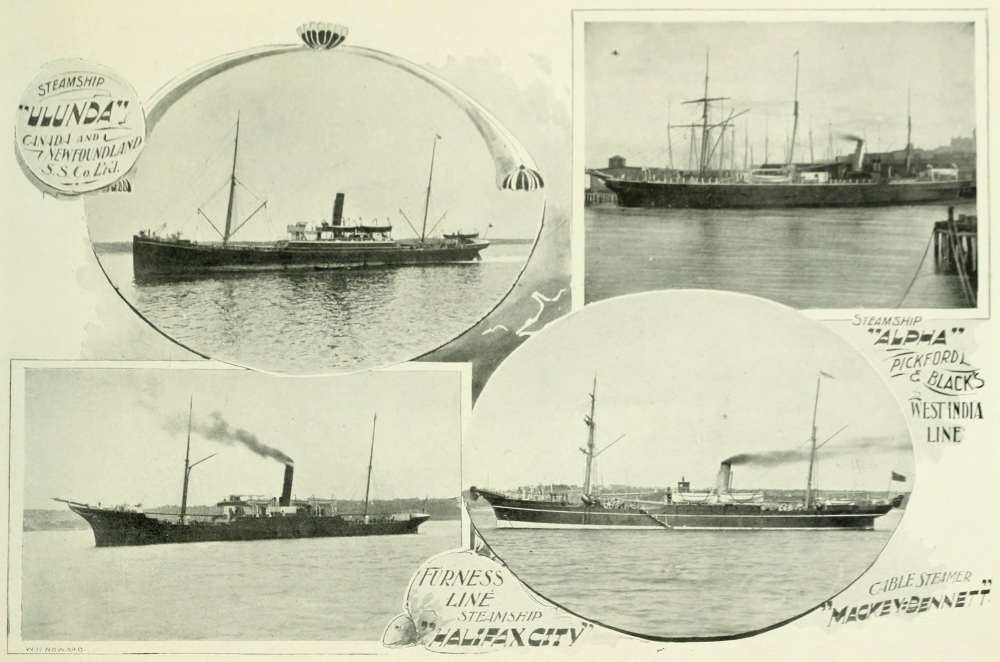
Some typical ships in Halifax harbour c1900.
Masts on which to hoist sails are still present to supplement coal-fired steam engines.


from: Nova Scotia Illustrated, November 1895; GH Bradford. on archive.org
This interesting map identifies the smaller piers
The concentric circles show the distance from the Post Office.

from: Nova Scotia Illustrated, November 1895; GH Bradford. on archive.org
An enlargement of the map above shows the ICR facilities.


detail from: The Railways and Canada's Greatest Disaster; Douglas NW Smith; Canadian Rail No 431, Nov/Dec 1992; CRHA
The 'corrected to 1917' map from the Douglas NW Smith's article in Canadian Rail is shown above 
... and, below, rotated 180 degrees for legibility.
'X' marks the location of the Halifax Explosion.

detail from: The Railways and Canada's Greatest Disaster; Douglas NW Smith; Canadian Rail No 431, Nov/Dec 1992; CRHA

The ICR/CGR features are enlarged below.

detail from: The Railways and Canada's Greatest Disaster; Douglas NW Smith; Canadian Rail No 431, Nov/Dec 1992; CRHA

*  *  *

from: Cinders & Saltwater - The Story of Atlantic Canada's Railways; Shirley E Woods; 1992; Nimbus. 
The photo above jumps ahead in history for just a minute. 

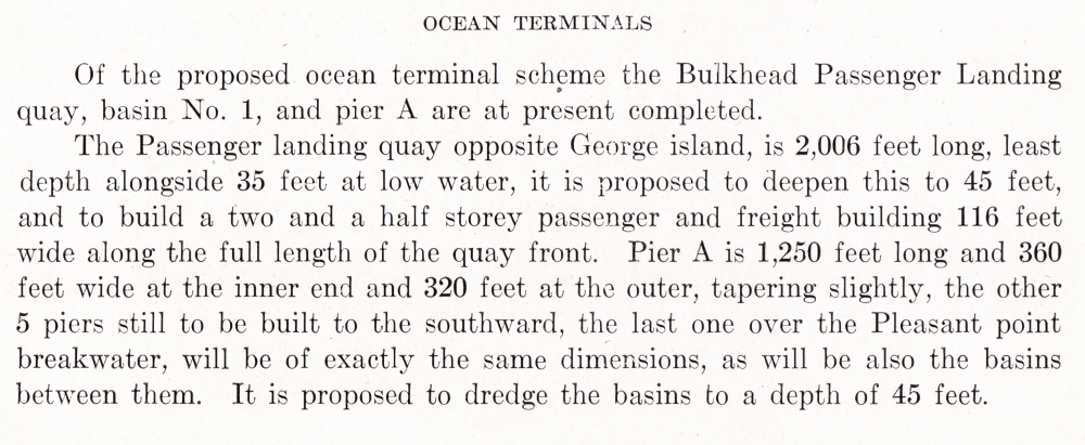
Circa 1928, this photo shows the general arrangement at Pier 2 ... located within the 'ICR Piers' area in the map above. Canada's famous immigration location 'Pier 21' is located at the Ocean Terminals area ... out at the mouth of the harbour. Before Pier 21, this Pier 2 was the immigration pier. It was also used for departing and returning soldiers during the Great War. As Pier 2 was extensively damaged during the Explosion, this photo represents it after rebuilding.

*  *  *

During the Great War ... after the Halifax Explosion ...


After the Halifax Explosion, everyone got such a Royal Pranging - particularly the pilotage service at Halifax Harbour. 

.. As if the Great War was otherwise so perfectly conceived and efficiently organized by the Generals and Admirals! 

Then there were the lawsuits back and forth between the owners of the Imo and Mont Blanc - each claiming the other was at fault. 

... One fine morning, someone tries to do things in a hurry and it makes all kinds of paperwork for everybody - not even considering the needless loss of life at Halifax. But the whole theme and lesson of the Great War is the needless loss of life.

*  *  *

Modifications to the Halifax Ocean Terminals Plan

Jim Christie found and forwarded this article describing the post-war adaptation of the more elaborate plans made for the Halifax Ocean Terminals before the Great War. I had wondered aloud to him about the process which caused the final design to be so different and he answered my question with this article!

... With the damage to the old Halifax harbour made by the Halifax Explosion of 1917, it made sense to accelerate the development of the more spacious Halifax Ocean Terminals. The article explains the changes made to the original plans and it documents the construction completed by 1920. This was the genesis of Canada's storied Pier 21.

Two images follow the article so you see the practical compromises made to the more elaborate pre-war design.


from: The Railway Contractors; Geoffrey W Taylor; 1988; Morriss Publishing, Victoria.

I have reposted the images above (projected plan) and below (postcard view, circa 1960) so you can see how the elaborate architecture was modified due to the realities of Canada immediately after the Great War.

The images view the area from roughly the opposite directions. The drawing above is viewed from the north. The photo below was taken from the south.


*  *  *

Meanwhile ... back in the 1920s ...

Unless noted otherwise, all of the following images come from Canadian Port and Harbour Directory; 1923; Government of Canada.


Above, at the top of the map, you can see the original Intercolonial Railway tracks terminating in the Pier 2 area. 

The new Ocean Terminals (dotted outlines) and the Pier 21 area appear near tiny George's Island.


Above, the camera takes in little George's Island and looks toward the ocean.


This is probably the most interesting of these images. Across the Narrows is Halifax. The open ocean will be to the left. 

If you look closely at the far shore, you'll notice that the individual buildings stand out as the land rises from the harbour. Between December 1917 and when the photo was taken in 1922 or so ... the blasted remains of destroyed buildings have been removed. However, except for buildings which survived and were repaired, and new construction, great expanses of urban land persist as vacant lots.


CGMM = Canadian Government Merchant Marine


The map below shows the old Intercolonial area near the end of World War 2.


from: The Naval Service of Canada, Vol II; Gilbert Norman Tucker; 1952; Minister of National Defence. 

from: The Naval Service of Canada, Vol II; Gilbert Norman Tucker; 1952; Minister of National Defence.
The map above shows why the geography of Halifax has been important in armed conflict since its first discovery by Europeans.


21 July 2016

Halifax - Port and Railways - 1900-1920


This post looks at the railway system around Halifax before and immediately after the Halifax Explosion of December 6, 1917.


Previously, a post looked at Halifax during our visit in 1982. Jim Christie forwarded additional material from the professional journal Canadian Railway and Marine World  at archive . org from 1914 on the Ocean Terminals which I appended to that post. 


Jim kindly sent additional references from early 1918 on the Halifax Explosion. They caused me to explore that volume further and both sets of research appear here. A subsequent post will wind-up Halifax for the moment, with post-war historical information which I'd like to share.


Postcard mailed in 1907.
The postcard above includes the location of the Explosion in the 'Narrows' of Halifax harbour. The Intercolonial facilities and terminal are shown here. The card is based on a daytime photo which has been colourized to simulate night.

The multi-storey dome at the extreme top left is that of the North Street Station. The large distant building at the shore with a smoking chimney is a sugar refinery.

from: Vanishing Canada; Rick Butler, 1980; Clarke Irwin & Co.
Coaling the HMS Ariadne c1900, Halifax.
This Royal Navy cruiser was launched in 1898 and was torpedoed in July 1917 - a few months before the Halifax Explosion
(A warship can been seen docked at this location in the postcard above).

A sister ship of this class, the HMS Niobe, became the second ship in Canada's 1910 'tinpot navy' of two vessels. The HMCS Niobe was docked in the harbour on the morning of the Explosion. A crew of seven sailors from the Niobe - intending to assist in managing the burning SS Mont Blanc - was killed by the Explosion as they boarded the ship.

Just before the Great War began, on the west coast, the HMCS Rainbow (Canada's other second-hand warship, launched in 1891) 
became involved in the Komagata Maru incident.

*  *  *

The map below is from a Government of Canada atlas from 1915. The Intercolonial terminal and station are clearly shown. A constituent of Mackenzie and Mann's Canadian Northern system, the Halifax and South Western can be seen approaching from the bottom of the map. A better map with more detail on the railways and harbour follows below. The general layout of Halifax is presented well with this map - north is off to the top left. 

The new Ocean Terminals, whose development was modified and accelerated by the devastation at the Narrows, are represented by dotted lines at the right by Point Pleasant.

from: Atlas of Canada; 1915; Government of Canada.


from: Atlas of Canada; 1915; Government of Canada.


Advertisement from a 1908 book about boating on Halifax's 'North West Arm'.
This advertisement is provided for Canadian Northern fans, to show a variation of the railway's herald.

*  *  *


from: The Halifax Catastrophe; 1917; Royal Print and Litho from archive.org
You've all seen mushroom clouds before, but this cloud of water vapour and gas was something remarkable back then.

The Halifax Catastrophe (at archive.org)

*  *  *

from: The Spokesman-Review; December 10 1917, Spokane, Washington.
This event is well-documented.
This was the only reference I could find to it
in the newspapers at the Google News Archive Search.


*  *  *

By the time the account below was written - referring to the Canadian Government Railways - this fore-runner of the CNR had begun to gather up the CNoR and other private enterprises starved for capital by the Great War.


from: Canadian Railway and Marine World, Feb 1918.

A point which Douglas NW Smith raises in his 1992 Canadian Rail article on the Explosion, is that the area of Halifax behind the hill on which the Citadel stands suffered less damage as the blast force was redirected by the hill.

One point I can add from reading extensively about the strategic bombing of Europe during World War 2 ... railway lines are remarkably resilient. Full terminal operations and high speed through traffic may be difficult to restore quickly, but a single simple railway track can be put into service within hours of heavy blast damage. And unlike strategic bombing, Halifax railway infrastructure experienced more of a horizontal force ... rather than large quantities of high explosive designed to form deep craters. 

A particularly tragic aspect of the post-blast period was that a blizzard swept through the area depositing over a foot of snow. This made the rescue of people trapped in collapsed buildings more difficult and interfered with the arrival of trains bringing medical personnel and supplies.


from: The Railways and Canada's Greatest Disaster; Douglas NW Smith; Canadian Rail No 431, Nov/Dec 1992; CRHA.
The contemporaneous map above is included in an excellent, detailed article (referenced above) by Douglas NW Smith in Canadian Rail which was published on the 75th anniversary of the Explosion. The map above is reproduced from the original, but you can also find the article linked to the Exporail website - where you'll find all the previous editions of Canadian Rail.

The Dominion Atlantic Railway ran into Halifax on ICR/CGR rails, and you'll notice the junction switch marked between the Halifax and South Western and the ICR/CGR. 'X' marks the location of the Explosion. Smith's article includes data and photos from the Canadian Railway and Marine World articles.


The account above gives a good summary of the relief trains which were brought in on the Canadian Government Railways.

The next post on Halifax will include data from a 1923 government reference book on Canadian ports. It gives an extensive description of the port facilities and activities around Halifax, showing developments completed after the war. 

The book is a professional reference for ship masters and there is no mention at all of the Halifax Explosion which occurred just six years earlier.


from: Canadian Port and Harbour Directory, 1923;  Government of Canada.

The map above shows Halifax harbour circa 1923.
The development of the new Ocean Terminals to the south is given prominence.