Showing posts with label Canadian Northern Railway. Show all posts

21 November 2025

CNR 1941 Montreal Public Timetable Folder 'L'

The opening of the new extension of the REM (Réseau express métropolitain) to Deux Montagnes provided me with the inspiration to post this little 3 x 7 inch pocket folder showing the schedule over some of the same route 84 years ago. 

Through the work of intrepid videographers who have posted their experiences on YouTube, I have enjoyed a few virtual trips over the newly-opened line. I am an avid comment reader and people there noted that it takes about four years to work out all of the glitches occurring on a new branch of a modern automated system such as the REM. 

... I have observed cases where the REM line to Brossard had an understandable reliability problem. The failing was made much worse by simply not having enough trained people to communicate with stranded passengers ... and to support them in person so they didn't feel they were abandoned in a locked glass and metal box. Sometimes management drops the ball when these new systems begin service.


Even during weeks when I am pressed for time/energy, I try to provide a few illustrations because people often enjoy looking at historical images rather than just using their imaginations to re-animate a dry, old schedule which has been photocopied onto the internet.

In one CRHA article I reviewed, there were images from the 1970s showing tremendous, long trains carrying commuters pulled by a couple of electric 'haulers', heading for the Mount Royal Tunnel and Central Station. Mackenzie and Mann would be proud to see their old equipment travelling on their old, cleverly-conceived route into the heart of Montreal. 

... One might be tempted to post these photos and opine on how much [more] was done [more cheaply] with the skilled use of the old reliable technology. 

I suppose the appreciation of human history can lead one to an alternative conclusion - that there is always 'new stuff' which replaces familiar technology. The old technology functioned, and was supported by its operators, in a predictable way so there were generally no unprecedented surprises. 

However, the new technology often offers immediate advantages, and even greater possibilities in the future ... if only the casual observer could foresee the system's future operations with the insight of an expert.


When this timetable was issued, a German amphibious invasion of England had been prevented by the success of the defenders during the Battle of Britain (and 'the stopping power of water' - the English Channel). 

Germany's fatal error of invading the USSR in a surprise attack began on exactly the effective date of this timetable. 

A similarly ill-considered Japanese attack on the US Pacific Fleet at Pearl Harbor was still a few months in the future.

The Battle of the Atlantic had not been going particularly well and the fatal weakening of Britain by U-boat destruction of food, materials, fuel and armaments was still a clear possibility.

... The people riding these trains probably had a lot to think about.

from: Report on Railway Terminal Facilities at Montreal; January 1929; Department of Railways and Canals.

On the map above, Bonaventure station is seen between St James and Notre Dame. The Tunnel Terminal appears near Windsor Street. This map of the CNR in Montreal was part of a 'Railways and Canals' government study to possibly develop a 'union station' for railway passenger service in Montreal.

For non-Montrealers, that new REM segment follows the route off the top left of the map through Roxboro.

For the purposes of the CNR, (according to Michael Leduc in Montreal Railway Terminals; 2008; Michael D Leduc Enr.) Bonaventure was "MONTREAL". Other terminals were identified by their names ... during the Canadian National Railways era.

The sharp-eyed will have noticed my map omits one pre-1950 terminal and that its CNR name is different from its 'familiar historical name' on the Folder's title page (above).

from: Montreal Then and Now; Bryan Demchinsky; 1985; The Gazette.

Things were so much better in the old days. People could go boating in railway yards. Before the construction of a levee on the St Lawrence to protect this part of the city, flooding was a regular occurrence - though not as bad as this extreme 1886 event. At the right, you can see the railway's freight sheds where boxcar contents were unloaded and transferred to wagons, perhaps sleds in winter, with draft horses providing motive power.

This was the first version of a Grand-Trunk-sized Bonaventure station. A new high-Victorian-style Bonaventure was built in 1887. These two photos are extra large so people can see historical details if they enjoy that kind of thing.

From somewhere within this scene was probably the original surveyor's stake which was the basis for all of today's mileage markers on the CNR Kingston Subdivision - although few current employees probably ponder this bit of historical trivia.
.

from: The Train Doesn't Stop Here Anymore; Ron Brown; 1991; Broadview Press.

Here is the interior of the 1887 version of the Grand Trunk Bonaventure station. First Class, Pullman tickets and Telegrams. 


Used, undated postcard.

Here is Grand Trunk Bonaventure (looking timetable west), after a fire in 1916 which resulted in its being rebuilt without its elaborate Victorian exterior. The stained glass windows apparently survived the fire. By observing the central windows, you can confirm where the black and white interior photo was taken. 

In 1948, a fire in the extensive neighbouring freight sheds, damaged the station building and this ended the use of Bonaventure for all passenger trains. Central Station had been open since 1943 and most intercity traffic had already been moved there, with Bonaventure left to anchor the CNR West Island commuter service.


Here are the 1941 tables for Bonaventure.


*  *  *

Tunnel Terminal

Unused postcard.

Mackenzie and Mann's Canadian Northern MONTREAL terminal began operation when the war-delayed Mount Royal Tunnel was complete in 1918. 

With the almost immediate takeover by Canadian National Railways, this became known as Tunnel Terminal. And artists made ham-handed changes to the images on their postcards (see the station 'letterboard' above). The old Canadian Northern circular crests seem not to be altered here in the image, and the circular format was temporarily used to display 'Canadian National'.

from: Report on Railway Terminal Facilities at Montreal; January 1929; Department of Railways and Canals.

City Beautiful Urban Planners decried the hole opened up by this terminal and this 'scar' on the landscape persisted into the 1960s. 

Sadly for everyone, Mackenzie and Mann (and Sir Henry Thornton) had foreseen grand urban-centre developments over this hole, but none of these railway officers were around long enough, or were provided with the resources to carry out their plans.

Above, is a coarse-dithered 5-inch photo from the terminals report. At the left, you can see an electric locomotive and a couple of coaches. Two other sets of coaches are ready at other platforms, with boxcars on the express track to the right.

Here are the 1941 tables for Tunnel Terminal


Table 11 (above): St Catherine Street East Station
(aka Moreau Street)

from: Report on Railway Terminal Facilities at Montreal; January 1929; Department of Railways and Canals.

The green terminal under 'Ontario' marks the location of this station.

from: Report on Railway Terminal Facilities at Montreal; January 1929; Department of Railways and Canals.

Above: Another coarse-dithered 5-inch photo from the terminals report. Mackenzie and Mann obtained control of the Great Northern Railway of Canada in 1903 and this was its terminal. Presumably, this was the GNRC station known as MONTREAL. 

The Canadian Northern referred to it as the St Catherine Street East station. This was perhaps because it drew an attractive link to the main commercial street of Montreal. Or perhaps it was logical to use the St Catherine name if passengers were using the streetcar to reach the station.

Before the completion of the Mount Royal Tunnel, this was the terminal for Canadian Northern trains going to Ottawa and Toronto via Hawkesbury. Its use for trains to Joliette and Rawdon on the CNR ended in June 1945 when these routes were changed to terminate at Central Station.

Undated photo from article: A Historical Railway & Canal Atlas of Canada; CA Andreae; Canadian Rail, July 1980.


from: Google Maps

I believe the block once containing the Moreau St station is centred in the image above: Adam, Roy, St Catherine, Moreau. The former interchange connection between Moreau St and the CPR Hochelaga yard (just beyond the left margin) can be imagined.


19 July 2025

Tidewater Subdivision Profile (7.29 miles), Vancouver Island, Canadian National Railways

An interesting piece of track was built exactly 100 years ago.

In 1913, the Canadian Northern Railway built a line with a dock at Patricia Bay. This natural harbour was in the shelter of Saanich Inlet. It was strategically located just north of Victoria.

If you start at Victoria and head north ... pass through Elk Lake ... and find the big bay to the left of 'Sidney' on the map ... that's Patricia Bay.

Between Port Mann (on the mainland) and Patricia Bay, the CNoR operated their first coastal shipping and ferry service. With the financial failure of the CNoR, Canadian National Railways took over these operations.

from: CNR system map, published between 1929 and 1949.

The undated map above shows the Canadian National Railways line in green. The line to Kissinger was completed in 1928. Lumber and logs were products carried by the railway from the interior of the island and their export was accomplished by ship or float from Patricia Bay. 

... However, the CNR decided that the railway route all around Saanich Inlet to get to Patricia Bay was unnecessarily long. After the CNR created an alternate harbour, it pulled up the line to Patricia Bay in 1935.

... This alternative harbour was built by the CNR between Deerholme and Cowichan Bay ... the Tidewater Subdivision. For your convenience and pleasure, both Deerholme and Cowichan Bay are shown in red print on the map above.

*  *  *

Here's an older map ...

from: Atlas of Canada; 1915; Government of Canada.

The Government Atlas above pre-dates the previous map and shows data from 1915

... As a matter of cruel historical fact, the Canadian Northern had not completed the line northwest of Lake Cowichan to Alberni, and it never would. Apparently, the grading had been done as far as Alberni. Some of this prepared roadbed was eventually put to good use by logging company railways.

And, in the map's 'Canadian Northern territory' (very light green) you can see the (pre-Tidewater Sub) line to Patricia Bay ... It swings around through Victoria and up through Elk Lake and Sidney ... to the harbour at Patricia Bay (not labelled).

*  *  *

from: Atlas of Canada; Henry W Castner; 1981; Reader's Digest.

The CNR built the Tidewater Subdivision in 1925 and it was formally abandoned in 1987. You can see some YouTube videos showing that some of the rails are still in place in 2025. 

On the map above, railways are shown in faint grey, with the railway initials beside the line. You can see how the CNR was located from Lake Cowichan ... descending along the valley of the Cowichan River. 

Then, in 1925 ... in topographical triumph ... the final stretch of the Cowichan River valley was followed between Deerholme and the ocean at Cowichan Bay.

I've posted an enlarged, unaltered section of the same map, below, to show that the Tidewater Sub can still be seen on this crowded 1981 map ... It is shown running east from that grey railway junction east of Koksilah and runs east through the red dot with Cowichan 9 on it. 

When one spends at lot of time looking at atlases, one often finds that First Nations reserves were established at particular points. On this map, they are shown by red dots and pink shading. 

... Then ... with the First Nations reserves established ... years later ... someone finds a compelling commercial case to take advantage of the underlying industrial geography and 'something' is built which permanently alters the land originally set aside. 

... Examples which quickly come to mind are ... here at Cowichan Bay, or at Depot Harbour near Parry Sound, or along most of the the riverfront at Kahnawake where the Seaway was constructed. 


*  *  *

Cover of the Tidewater Subdivision profile:


The CNR crest is from the DB Hanna era. As you know, the Canadian National Railways temporarily adapted the Canadian Northern crest - by changing 'Northern' to 'National'. They also permanently adopted the CNoR's format for steam locomotive number plates.

*  *  *

A fruitful digression into Canadian railway and military history ...

In trying to date this profile, I searched for the name of the Chief Engineer, HA Dixon ... and the book, below, was presented as a link. It is stored as a downloadable PDF (in 2 volumes, linked below) on the website of the Canadian Geotechnical Society. 

I've kept copies of the PDFs. In the likely event that the website is reorganized and the book links cannot be found in the future (this always happens!), contact me and I'll send the PDF copies I've saved.

from: Westward Go Young Man; John L Charles; 1978; Canac Consultants. PDF via Google search from cgs.ca.

According to Westward Go Young Man, H.A. Dixon became CNR System Chief Engineer in 1939, leaving the post of Chief Engineer, Western Region CNR.

So, consistent with the old crest, the profile was created BEFORE 1939.

Westward Go Young Man, Volume 1

Westward Go Young Man, Volume 2

The author of the book, John Charles, was born in the UK where he obtained his civil engineering qualifications. His British training/western Canadian railway career path, are somewhat similar to those of Sandford Fleming, JHE Secretan, and P Turner Bone.

Here's a very brief overview of his Canadian railway experiences: He migrated to the Canadian west, where he worked on the locating surveys for the Grand Trunk Pacific Railway and both periods of construction of the railway line to Churchill, Manitoba. I've only skimmed parts of his book ... He also had military service in World War One.

End of digression, back to the profile of the CNR Tidewater Subdivision.

*  *  *


Some features of the Tidewater Subdivision:
  • At Deerholme, you can see that the station is west of the west switch of the wye. (G = grade crossing)
  • The Deerholme station is at Mile 0.0 of the Tidewater Sub and Mile 58.25 of the Cowichan Sub. You could picture the Tidewater Sub as a 'port spur' of the Cowichan Sub.
  • The track is laid with 60 pound rail and gravel ballast.
  • For most of the route from Deerholme to Tyup there is a down grade, often reaching 2%.
  • At Mile 3.8 there is heavy curvature, including one at 10 degrees.
  • There are many bridges from Mile 4 to Cowichan Bay.
  • The longest trestle is just before Tyup - 799 feet in length ... at the bottom of the grade.
  • Just before Tyup, the CPR passes under the line - but does not interchange.
  • Tyup is a well-equipped station: water tower, 4000 feet of siding, wye, telegraph office.
  • East of Tyup are more sidings, with a total capacity of almost a full mile.
  • In total, 208 cars can be stored between Tyup and Cowichan Bay.
Conclusions
  1. This would have been an expensive bit of railway to build.
  2. It would have been challenging to operate with heavy trains of lumber.
  3. It was built to accumulate and move a large number of cars for a busy port.
  4. Presumably, this railway 'storage/surge capacity' made it possible to completely load a ship with lumber without delay ... as fast as cranes could place the lumber in its holds.
*  *  *

A CNR employee timetable from 20 years later.
Near the end of steam motive power. 


Some key points:
  • Trains going east to Cowichan Bay are travelling 'timetable north'.
  • Retainers (to slow the release of the air brakes during recharging/releasing cycles) must be set while standing on the slight upgrade at Deerholme.
  • A single-occupancy manual block system on the heavy northbound descending grade Deerholme to Tyup is controlled by telephone by the operator at Deerholme - on duty 24 hours per day.
  • Fuel and water are available at Tyup.
  • The whole subdivision is within yard limits so all movements must be prepared to stop within half range of vision.
*  *  *

At Deerholme

from: https://youtu.be/6b5GBPmwoZo?si=yNJycXEGFfPO2Mxv
I will link this excellent YouTube account below.

*  *  *

At Tyup

from: Vancouver Island Railroads; Robert D Turner; 1973; Golden West Books.

This undated Stan Styles photo at Tyup shows some of the facilities there, the light rail, and the typical steam power used. The camera is facing toward Cowichan Bay.

This is from Robert D Turner's first book. In an interview, he said he wrote it because he went to the library to look for information on Vancouver Island railways and could find nothing on the subject.

*  *  *

At Cowichan Bay

from: https://youtu.be/6b5GBPmwoZo?si=yNJycXEGFfPO2Mxv

This preserved 8mm film shows the engine at the 'tail' of the dock switch with flatcars loaded with lumber. Next, it will reverse to the dock, where a freighter from Japan is being loaded with lumber. Notice the buildings 'of railway character' on the dock itself.

Below, you can see that the same features still exist on the Cowichan Bay dock circa 2025. 

from: Google

In 2025, if you open Google maps,
Search for Deerholme Junction,
Zoom in to Deerholme Junction,

I think you will find you are able to trace much of the former Tidewater Sub,
by following the 'Cowichan Valley Trail' east from Deerholme Junction.

*  *  *

If you are interested in the two YouTube screen prints of CNR steam on Vancouver Island, you should visit the following YouTube account.

Again, the link for that particular 8 minute video:

Account Description:

"8mm films of trains and ships taken by my Dad - Dave Wilkie, sister and Mom between the 1950's and 1970's.  
Thanks to my sister Lorraine for having these all converted to DVD."


*  *  *

After posting, Jim Christie sent me this excellent YouTube he found
about the last operations on the Tidewater Sub, featuring a 6-axle GMD1:


16 May 2025

GNRC 1902 Great Northern Railway of Canada - Hawkesbury to Joliette

Performing one of his intensive and thorough searches on particular historical topics, Jim Christie was probably looking for references to a hard metallic carbide. Instead he found an advertisement for flammable calcium carbide in a book entitled: Amidst the Laurentians; NM Hinshelwood; 1902; Montreal Herald - A link to the book is provided below.

 Jim was kind enough to share the reference with people interested in the region. 

The book's main subjects are the Great Northern Railway of Canada, and Shawinigan Falls.

The book's descriptive account of the attractions along the western section of the line follows below.

*  *  *

Here are the key legislative dates in the short life of the GNRC.

1883 

The Great Northern Railway Company was incorporated to build from St Andrew's [East, Quebec] to a point on the North Shore Railway via Argenteuil, Two Mountains, Terrebonne, L'Assomption, Montcalm, Joliette, Berthier, Maskinonge, St Maurice and Champlain Counties.

1884

An agreement with the Carillon and Grenville Railway Co was authorized.

1896-1898

Absorption of Lower Laurentian, Quebec and James Bay, Montfort & Gatineau Colonization, railways authorized. 

1899

Name change to Great Northern Railway of Canada authorized.

1905

Canadian Northern Railway allowed to lease the GNRC and to guarantee its bonds.

1906

GNRC, Chateauguay & Northern, Quebec New Brunswick & Nova Scotia, railways authorized to be reorganized to form the Canadian Northern Quebec Railway Company.

*  *  *

GNRC Map and Related Links


Book link: Amidst the Laurentians

The text says that the Joliette to Montreal line of the GNRC was not yet completed.

To review the Moreau Street terminal, along with the other terminal stations which the CNR inherited ...

you may wish to check my earlier effort to organize them in my own head ...

Earlier post on the evolution of CNR's Montreal Terminals


This map conveys a lot of information with the informality of a pen and ruler.


Horse-drawn binders harvest the richness of the Prairies, as labourers 
(often new immigrants) stook the sheaves of wheat to dry.


Somewhere in the centre-distant urban coal smudge is the way west. Only small canal boats can ascend the Lachine Canal on their way via the St Lawrence, and its small Canadian canals, to the Great Lakes. 

At the extreme right, the Bonsecours Market (primarily farm produce) is in full operation. 

To the Market's left, in the distance, boxcars on the Grand Trunk harbour tracks empty their freight into dockside freight sheds, for loading onto coastal and ocean-going ships. 

At the water's edge, a line of carriages awaits passengers alighting from the shallow-draft paddleboats. A spectacular excursion for tourists is offered by one of them on the page below. Other boats will travel to ports along the St Lawrence and its tributaries ... and up the Ottawa River canals.

*  *  *

Below: Notre Dame Basilica's twin spires, grain elevators and the Victoria Bridge are seen against the St Lawrence.


Above: The Bank of Montreal head office (with its fluted pillars), where Donald Smith and George Stephen could often be found.


I purchased this photograph of a postcard at a railway show. This view looks down the Ottawa River with Quebec and the Grenville Canal on the left bank. This canal is the waterway which some of the Montreal Harbour paddleboats would have travelled. Hawkesbury, Ontario is on the right bank. 

The closer bridge is the Perley (road) Bridge. The distant bridge is that of the GNRC/CNoR, later the CNR.

The Perley Bridge

Jim Christie recalls that his father (about age 10) was, without prior arrangement, deputized to help cut the ribbon to open the Perley Bridge in 1931 at its official opening ceremony. 

The project was originally promoted by Argenteuil MP George Perley (1857-1938) in 1909 ... and was named after him when it opened. Perley served as Canadian High Commissioner to the United Kingdom and Minister of the Canadian Overseas Military Forces during the Great War.

The bridge was finally constructed in 1930-31 as a 'make work project' early in the Great Depression. The bridge was re-constructed to raise it by 10 feet or so in 1961 as a result of the building of the hydro dam at Carillon (12 miles downstream, built 1959-1964). This reservoir raised the Hawkesbury water level by about 10 feet.

I often travelled over this bridge on weekends in the late 1970s and its age (almost 50 years old), narrowness, and added height provided a certain sense of ... adventure ... when the bridge was shared with one of the many heavily-loaded trucks engaged in interprovincial commerce!

While the railway bridge was designed to carry that kind of weight, large diesel-powered (often overloaded) semi-trucks had not been foreseen in the 1930s. And a traffic light right at the foot of the long, steep bridge ramp on the Quebec side kept everyone on their toes.


*  *  *

Below, this view of the railway bridge is from the Hawkesbury, Ontario side, looking up-river.


Above: The up-river (left) and down-river views of the Wilson Paper Mills dam on the North River.


27 October 2023

From Valcartier to Vimy - Postcards x4

Years ago, these Camp Valcartier postcards were probably all purchased from the same dealer. I did notice the Canadian Northern equipment right away (a map and track profile follow). I don't think I ever realized how two of the postcards were connected.


Above: I thought it was quite practical that the military would use a standard house plan to quickly build a headquarters building. In fact, this was once a farmhouse - from one of the many farms purchased and expropriated as part of Canada's mobilization plan. At the onset of the war in 1914, Minister of Militia and Defence Sam Hughes threw the carefully-designed professional mobilization plan out the window and improvised on a grander scale. 

'Valcartier Camp' became much larger than previously planned. Originally 2000 hectares had been purchased in June 1913 to train 5000 soldiers. With the outbreak of the war Hughes added another 3480 hectares ... for a total of over 50 square kilometres.

*  *  *

That Sam Hughes! ...

For most of his life, Hughes was an enthusiastic member of the militia. He was disappointed when he was not allowed to participate in putting down the North-West Rebellion in 1885. Hughes eventually found his true calling as ... the owner of a local newspaper (the Victoria Warder) ... an MP from Lindsay, Ontario ... and a government minister. 

He didn't like: Catholics, French-Canadians, professional soldiers, and anyone who disagreed with him - he was always right. As minister, he tried to award himself the Victoria Cross for his activities during the Boer War. During the Boer War and the First World War Hughes was never under the command any officer in the chain of command, but he always wore his militia uniform.

For army officers who were accustomed to a chain of command and a proper professional way of doing things - at Valcartier, or in Europe - the constant interference of Sam Hughes was frustrating. As Hughes prowled around, he didn't hesitate to dress-down officers in front of those under their command.

He was a tough man who liked physical fighting and he loathed 'softness' in men. He had typical Victorian views on the superiority of the British way. His certainty that citizen soldiers were superior to full-time professional soldiers ... fit nicely into reality as the First World War ground on. The professional soldiers were quickly used up. 'Pals Regiments' (as invented by Kitchener) - made up of citizens with the same interests or in same profession - were used by Hughes to facilitate recruiting. 

The fact that he enjoyed 'militia-style shooting' contributed to his error in promoting the Canadian-made Ross Rifle. It was an excellent rifle, well-suited to target shooting and hunting. However, as the standard for Canadian infantry troops the Ross jammed under rapid-fire conditions and when exposed to battlefield dirt - of which there would be plenty. 

Getting back to Camp Valcartier ...

Looking at the newspapers of late 1914, there were many articles and railway advertisements regarding travel to Valcartier. The invitations was not limited to volunteers eager to join the army. The general public was encouraged to come, book a local hotel room, and observe the contribution the Dominion of Canada was making in its support of the British Empire.


You can see the Canadian Northern Railway coaches above. Cars without vestibules also appear in other photographs. Perhaps the latter were used in the final stages ... when railway shuttle trains were running between Valcartier and Quebec City as the men of the First Contingent, and their equipment, were being loaded onto ships.


While the Canadian Northern's Quebec and Lake St John Railway provided material support for the Valcartier effort - the Canadian Northern would soon become an early casualty of the war. When the shooting started, Europeans and Americans had more lucrative investment opportunities than wilderness railways. Perhaps the federal government could help?

Canada, itself, was having cashflow problems as it picked up the tab for its military contributions to the British Empire. This national financial burden actually aided Hughes in his insistence that the Canadian Expeditionary Force should fight as one unit under Canadian command ... and therefore under his influence as the minister in uniform.

Perhaps this was Hughes' one redeeming quality. And we'd probably agree with him that the British Empire's military hierarchy was often terribly condescending in its relations with its colonies ... er, I mean, dominions.

*  *  *

The paragraphs below come from a 450-page American book about the first few years of the war. It included a 30-page supplementary chapter, tacked onto the end, about Canada's effort. 

... Actually, on August 4th, ... the Government didn't yet own all of Valcartier.


from: Europe's Greatest World-War; Thomas H Russell/John A Cooper; '1914'; JL Nichols Co, Toronto.

... a plan of Camp Valcartier on the internet shows a number of stub tracks, short pocket tracks and a balloon track for the quick turning of passenger train consists.

*  *  *

On the government railway map from 1906 below, you will recognize some names of railways which became part of Mackenzie and Mann's eastern Canadian Northern Railway network. If you spot the red Quebec & Lake St John label ... the original settlement of Valcartier can be seen to the right of the red letter 'Q'.
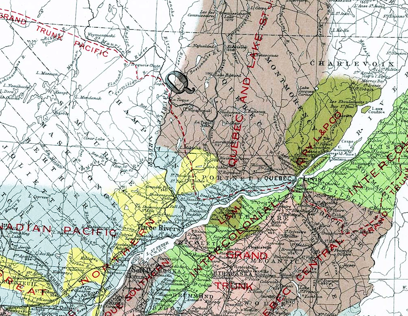
from: Atlas of Canada; 1906; Government of Canada. natural-resources.canada.ca 

*  *  *

Here is the profile of the Quebec & Lake St John railway and you can see that Valcartier is about 17 miles from Quebec City. 

from: Bibliothèque et Archives nationales du Québec

*  *  *

The two linked postcards ...


There was a large circus-size tent which housed a drop-in and support centre - signed as a 'chez nous' for soldiers at Camp Valcartier. These two postcards to Ontario - one for Port Dalhousie and one for St Catharines - were probably obtained there. Virtually all of the thousands of soldiers here were housed in those bell tents shown above. There were few permanent buildings at Valcartier and you can often see farm houses and barns in the distance.

The wartime departure dates of solitary fast troop transports, and convoys, were kept as secret as possible as the U-boat menace developed. This first large wartime convoy of World War One seems to have been less of a secret. 

The large movement of soldiers and ships - escorted by British warships - probably overwhelmed the organizational readiness of both the German U-boat fleet and the Canadian officers and chaplains responsible for censoring mail.

*  *  *


The addressee is rotated 180 degrees and reproduced below so you can read it more easily.


*  *  *


from: The World War, Vol 1; Holland Thompson; 1921; Grolier Society.

This painting looks more impressive in full colour, but I wanted to include this century-old description.
Accounts state that this was the largest convoy of ships to ever across the Atlantic, up to this point.
Harold Wolhaupter would have been on one of these ships.

from: The World War, Vol 1; Holland Thompson; 1921; Grolier Society.

And Harold Wolhaupter would have spent about 4 months camped out on this plain. It was one of the rainiest winters on record. Epidemics of diseases such as diptheria and meningitis made the rounds of the soldiers living in tents, pitched in the standing water on the poorly-drained fields.

Across the Channel, the early 'war of movement' was bogging down. After the Germans failed to take Paris, they made tactical retreats to nearby high ground and dug in. The stalemated trench war began. 

Initially, those commanding the armies of the British Empire didn't know quite what to do with the troops from the dominions and colonies. Training in the rapidly-evolving tactics of trench warfare seemed to be a good investment ... at least until the necessary deployment decisions could be made. 

... Differences of strategy between the British and their French allies often made things complicated.


from: The World War, Vol 1; Holland Thompson; 1921; Grolier Society.

Notice how young they are.

Trenches were used, because they saved lives. With the potent weapons of modern industrialized warfare ... like the machine gun, quick-loading field guns, and howitzers, the soldiers had to be below ground level just to survive. However, trenches provided no protection from poison gases - such as the heavier-than-air chlorine gas which the Canadians experienced at the Second Battle of Ypres in early 1915.

*  *  *

Meanwhile, recruiting efforts had already been underway for the Second Contingent of the Canadian Expeditionary Force ...

from: Canadian War Posters; Marc H Choko; 2012; Worth Press.

The war dragged on. Extensive barbed wire entanglements placed in front of the trenches funneled enemy attackers into paths through the wire which were well-targeted by machine gun emplacements. Artillery barrages directed at the other side's elaborate trench networks took a steady toll on those rotating forward to occupy the front-line trenches, those occupying the front-line and those rotating back to rest areas. 

Fatigue parties were kept busy with activities like resupplying the front line with food and ammunition, reinforcing parapets, dugouts ('artillery bomb shelters') and trenches ... and working on the barbed wire entanglements by night. 

Telegraph and telephone network wires were in constant need of repair by specialists as wires were broken by artillery fire. Runners (including one named Adolf Hitler on the other side) filled in gaps in the communication systems ... ensuring that the commanders at the rear could send orders all the way to those in the front trenches.

From time to time the enemy's trenches would be seized in an attack. A hasty engineering effort then had to be made to build a defensive parapet and firing step to protect against an immediate counter-attack. The enemy trenches and territory 'won' and held would contain water, mud, corpses, bodies torn apart by artillery, shallow improvised graveyards and the ever-present well-nourished battlefield rats.


from: Canadian War Posters; Marc H Choko; 2012; Worth Press.


*  *  *

Harold Wolhaupter in France in 1917

The map below shows the status of part of the Western Front, two-and-a-half years after Harold Wolhaupter left Valcartier.

The map shows the front lines in the days immediately after Canada's 'coming of age as a nation' at Vimy Ridge.

Harold Wolhaupter will be going into battle at Fresnoy.

from: Official History of the Canadian Army in the First World War; Col GWL Nicholson; 1962; Minister of National Defence.

*  *  *

A German soldier's memoir of World War One includes this typical description of the artillery barrages
in the days before the Canadian advance to take the little town of Fresnoy and the area around it.

from: Storm of Steel; Ernst Jünger; 1920,1961; Penguin.

*  *  *

The Canadian advance on Fresnoy.

from: Official History of the Canadian Army in the First World War; Col GWL Nicholson; 1962; Minister of National Defence.

[The account discusses Lieutenant Combe. In this paragraph, it should read 'enemy' grenades (not 'energy' grenades). The scanning and proofing of a hard-copy book into electronic form would be a long and tedious process.]

from: Official History of the Canadian Army in the First World War; Col GWL Nicholson; 1962; Minister of National Defence.

Above, is the account of the events on 3 May 1917.

Below, is the account of the Germans' recapturing of what was left of Fresnoy on 5 May 1917.

from: Official History of the Canadian Army in the First World War; Col GWL Nicholson; 1962; Minister of National Defence.


*  *  *


Sergeant Harold Phillip Wolhaupter (age 22) of the Canadian Infantry, Central Ontario Regiment 
was killed during the first day of the battle at Fresnoy, 3 May 1917. 
His name is recorded on the Vimy Memorial.

He was the only son of Mary Adelaide Wolhaupter, of 9 Salina St, St Catharines, Ontario, 
and the late George B. Wolhaupter. (source veterans.gc.ca).

"Inscribed on the ramparts of the Vimy Memorial are the names of over 11,000 Canadian soldiers 
who were posted as 'missing, presumed dead' in France."


from: Books of Remembrance, Peace Tower.
veterans.gc.ca