Modern historical interpretation finally gives us a clue!
Virtually nothing is left of the former fur-trading 'district headquarters'. The last enduring fragment of the old fort has stood there as 'something, something old' for almost 150 years. One could collect postcards down through the ages (see below) but still not understand what one was looking at.
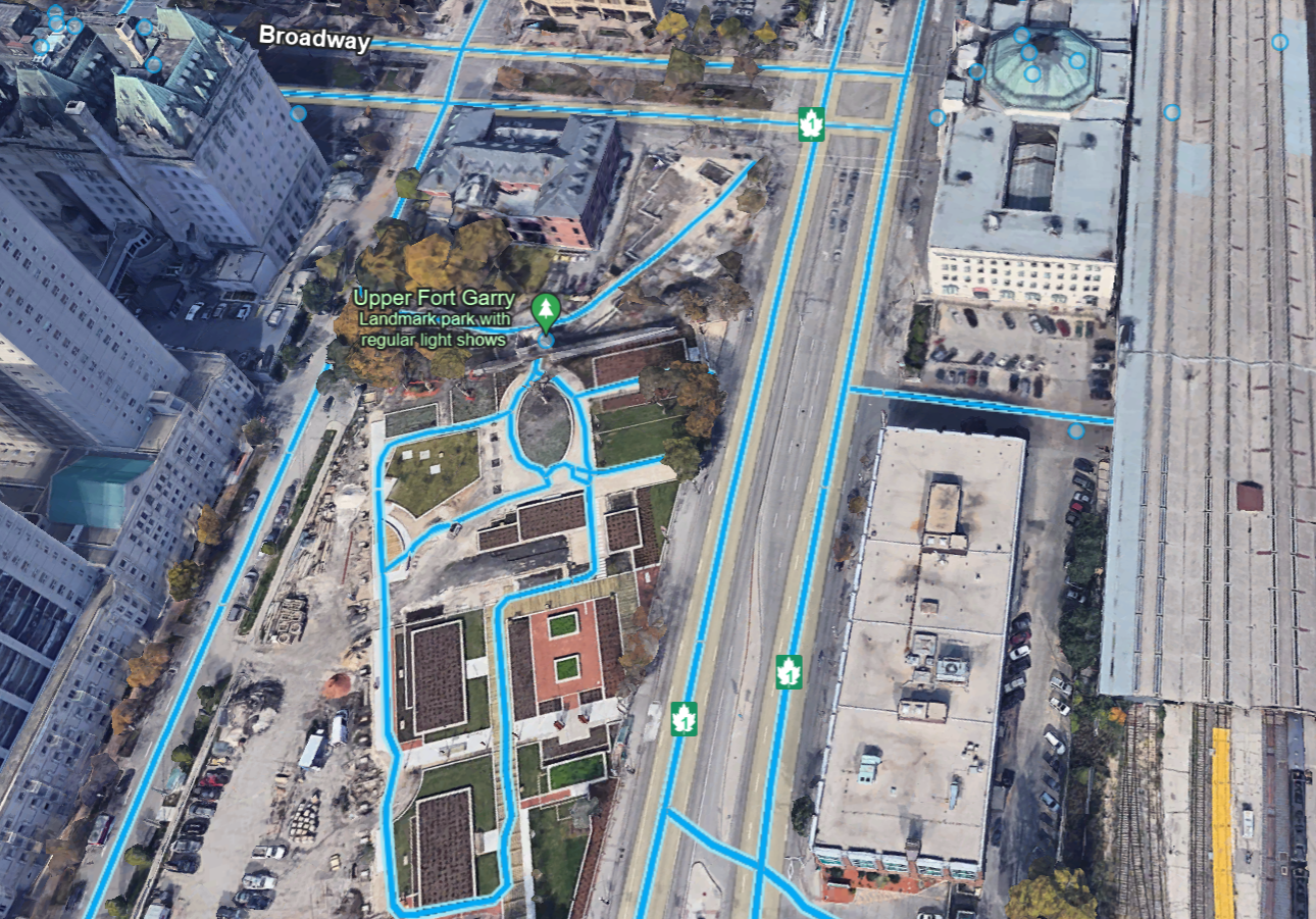
Without puzzling over postcards or going through history books or university map sites, you can begin to guess where Fort Garry once was ... just by looking at the image below.
Your starting point for this voyage of discovery is the surviving fort gate, located where the national-parks-evoking fir tree image points.
 |
| from: Google Earth |
Nicholas Garry was an unmarried London-based director on the Hudson's Bay Company Committee (i.e. board of directors) ... who volunteered to travel to Canada ... to communicate the news that the North West Company and the Hudson's Bay Company would cease their trading rivalry and violence ... and consolidate as one organization.
This combination was forced by the British government which was 'tired of you two kids fighting in the back seat!'
Simon McGillivray was appointed to represent the North West Company on the same mission. Garry and McGillivray were breaking this news primarily to gatherings of the wintering partners as they travelled.
In July or August of 1821, they reached the Red River Colony (also known as the Selkirk Settlement) and then it was off to Norway House.
In 1822, the newly-established HBC fort 'at the Red River Colony' was named Fort Garry in honour of Nicholas Garry's work and visit during the previous year.
* * *


While the circa Edwardian postcard scene may be 'English-looking' ...
maybe that's not exactly what we should be aiming for when considering this artifact of Canadian history.
The other building was the home of the Manitoba Club before a new building opened in 1905.
* * *
 |
| from: Canada's Five Centuries; W Kaye Lamb; 1971; McGraw-Hill. |
The source 4 inch by 5 inch image above depicts Fort Garry as it would have appeared in 1867.
You can see our still-surviving cube-shaped north gate of Fort Garry ... centred on the left end of the fort. In the foreground is the Assiniboine River. It empties into the Red River. The Red is seen on the far side of the fort and flows right (south) to left (north).
The Forks was an essential commercial junction of two significant early Canadian transportation assets - the two rivers.
A TV show once pointed out that the historical grand entrance to the Taj Mahal was on the Yamuna River side - because important guests travelled by water and would be received there. The everyday 'tourist photo' of the Taj Mahal is actually of its back yard ... where Shah Jahān would keep things like his propane barbeque, compost bin, etc.
Similarly, the image above shows steamboats, York boats, canoes, wagons and carts working out of The Forks-side gate ... which is not the gate which was preserved. It seems likely that touring fur trade big shots would have arrived by water at the south gate.
In 1822, through the governor's north gate, he could travel by road to ... the Red River Colony ... and return ... and that's about it.
* * *
 |
| from: Manitoba Historical Maps; https://www.flickr.com/photos/manitobamaps/3170781512/ |
The image above suffered some kind of computer glitch when it was being digitalized for the internet, but you can still read all the labels.
* * *
 |
| from: Historical Atlas of Manitoba; Warkentin & Ruggles; 1970; Historical & Scientific Society of Manitoba. |
Above, the North West Company's name for its installation at The Forks was Fort Gibraltar. On this very flat region of the Prairies ... canoes would approach the fort at water level along the eroded river valleys. From that perspective, the NW Company's post probably took on a Gibraltar-like appearance.
* * *
 |
| from: Historical Atlas of Manitoba; Warkentin & Ruggles; 1970; Historical & Scientific Society of Manitoba. |
With Fort Garry (the future site of Winnipeg) in the centre of the map ... and Fort William (part of the future Thunder Bay) in the lower right corner ... you can see the river systems and lakes which facilitated commerce and travel early in Canadian history. Weather permitting.
After meeting the wintering partners at Fort William ... Nicholas Garry, Simon McGillivray, paddlers, et al travelled ... across Lake of the Woods, down the Winnipeg River, across part of Lake Winnipeg, and up the Red River ... to reach the Red River Colony ... (and next year's Fort 'Garry' - shhh, it's a surprise!)
* * *
If this card is indeed from 1924 ... they didn't wait long to ensure the postcard said CNR instead of Grand Trunk Pacific Railway Fort Garry Hotel.
Covered in fuzz, here is the fort's back door - again - as it would have appeared from inside the fort.
* * *
* * *
On the horizon you can see the Manitoba Legislature at the left, and the Fort Garry Hotel at the right.
* * *
Part of an interesting map from 1911 appears below - back then, the only 'CNR' was the private Canadian Northern Railway.
The quoted link under the image will take you straight to the high-resolution image, which is full of railway history.
 |
| from: Manitoba Historical Maps; https://www.flickr.com/photos/manitobamaps/2825450318/ |