Showing posts with label running trades. Show all posts

25 January 2020

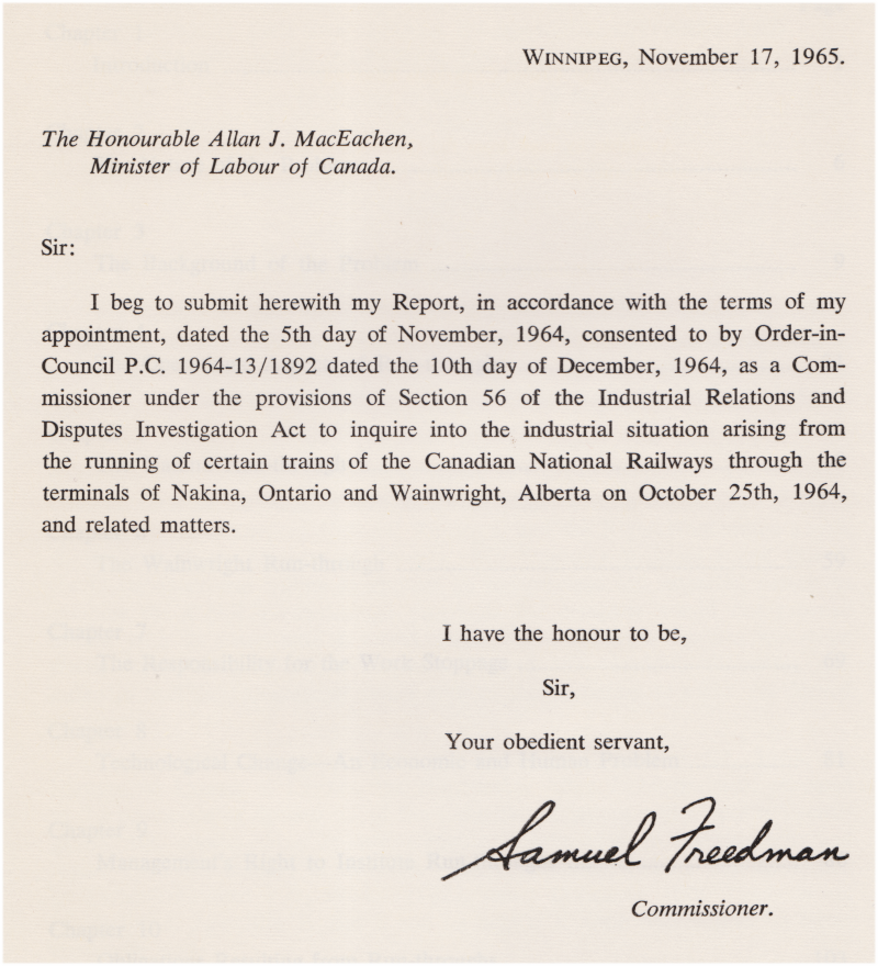
"A Strange World" - The 1965 Freedman Report on CNR 'Run-Throughs'


Here is a contemporary account, by a judge, of working conditions for running trades crews in the early 1960s. As the author notes, the actual collective agreements and arrangements use specialized language, customs, and vocabulary " ... this is a strange world ... ". I always like to find and post accurate contemporary non-specialist accounts to better describe the 'human experience' of railroading for a general audience.

After World War 2, new technologies were widely applied to Canadian railway operations. Key among them was the diesel-electric locomotive - which replaced the more labour-intensive steam locomotive.

Another was Centralized Traffic Control - which (generally, according to some) could enable a single main track to safely handle the traffic of two main tracks dispatched using the traditional 'time table and train order' system.

Computerized (teletype-style) waybilling and consist management systems enabled centrally-stored customer-linked data to be efficiently shared with multiple points on a railway. No longer were paper-schlepping and telegraphing/telephoning necessary to obtain updates on the status of shipments and train consists.

Fewer occupied station buildings, simpler locomotive shop facilities at most terminals, and (most importantly for the railways) fewer people were needed to support operations as the result of these new technologies.

Almost 60 years ago (as I post this) an experienced Manitoba judge was appointed to look into changes to Canadian railway operations pursuant to a labour action which interfered with the CNR's operations. You can find a page about his career on Wikipedia. While the rest of the report is interesting, the layperson's description of the running trades is probably the most valuable chapter to reproduce here.

Essentially, in late 1964 the CNR wanted to use efficiency gains from diesel locomotive technology to eliminate Nakina, Ontario and Wainwright, Alberta as crew change points. In the course of discussing the changes, the judge notes that the company contributed to the dispute because "[the workers had] the disquieting feeling that they were being exposed to a plan whose implications had not been fully examined."

In late October of 1964 over 700 running trades employees booked off sick on the Great Lakes Region. By 18hr on Saturday, October 24th, 1455 running trades employees booked off sick on the Mountain Region and 659 on the Prairie Region.


In May 1963, an eastbound CNR local freight passes 40th Avenue, Lachine, Quebec.
The CPR line appears in the distance.


Note: 

A Division was often formally defined as the portion of a railway assigned to the supervision of a Superintendent.

A Subdivision was often formally defined as the portion of a division designated by (employee) time table.

... And many subdivisions in timetables were about 125 miles in length. 

Whether a "division point" is where a Division is headquartered or where steam locomotive engine crews traditionally changed ... is something which could be passionately argued to infinity on the internet. I have not noticed that term in this report.


A morning CNR eastbound is seen at 48th Avenue, Lachine, Quebec in March 1961.
This photo was taken when the former Grand Trunk Railway line still ran along where today's Victoria street is found.
The 'get over the road' efficiency of diesel locomotives for fast run-through freight is illustrated well.


During my PSBGM Christmas holidays in December 1968,
a westbound CNR freight is seen from Lachine's 40th Avenue pedestrian overpass.
Wooden cabooses were still in use.


The largest paragraph above suggests that a prolonged period in the hole might be considered 'rest and relaxation'!

One should take care to determine whether crew members sitting in a siding for an hour or two are experiencing rest or fatigue.

... Variables such as time of day, previous hours of sleep and quality of sleep, time between trips,
noise, vibration, temperature, the requirement to remain consistently alert while on duty
might be considered here.


During an NRHA wayfreight fantrip to Ste Hyacinthe, Quebec in May 1964,
my father took this photo from the fan-coach/fan-openend-gondola car section of the train.
The camera is looking north, through the caboose, with the Victoria Bridge in the distance.


05 April 2015

Officials, Running Trades, Operators and Dispatchers


When I went to work in Schreiber in early 1977, I saw it almost at the end of its special status as a 'railway town'.


Years later, I found a book which helps preserve and explain 'the big picture' of life in small towns such as Schreiber and White River - which were railway towns first and foremost, for the better part of a century.


The following pages come from Minetown, Milltown, Railtown - Life in Canadian communities of single industry; Rex A Lucas; 1971; University of Toronto Press.


When doing sociological studies, it is a serious business to maintain confidentiality. In this book, there are no clues suggesting which railways or communities were studied. Of course, personal interview data was also kept in strict confidence.


The author's approach as a sociologist in this book:

.. 'begins with an individual, his hopes, fears, problems, solutions and the habitual associations of his daily round of life. After informal chats or formal interviews with many individuals, the sociologist begins to see persistent patterns, some shared by all, others shared by certain respondents. During the course of the interviews it becomes clear that some respondents think that their problems are personal, unshared, and not understood by others, but other perceptive respondents are aware that many share the same difficulties because they see them as arising from a common source in their place of work, their community, or their nation. The sociologist has the advantage of listening to more people in more communities than any one respondent; this enables him to locate patterns about which many individuals are unaware. The accumulated advantages are even greater if, as in this study, the sociologist is able to undertake all of the interviewing, rather than relegating the work to others.'

'The first patterns for this book were found after interviewing many people in Railtown, Ontario.'

[ ... ]

'These patterns were confirmed in interviews and in questionnaire replies from a much wider range of communities of single industry throughout Canada. It is these common patterns, intrinsic as they are in communities of single industry and with a population of under 30,000, that I have chosen to report here.'


from: The Standard, October 4, 1947, "Big Hill Railroading" collection of LC Gagnon


Power for Pilgrimage Trains, CPR Spanner, Nov 1949, collection of LC Gagnon


New Face on the Time Card (Train 901), CPR Spanner, Jun-Jul 1961, collection of LC Gagnon
'From the cab ot 901, engineer views eastbound passenger train 
during a twilight meet in the rugged woodlands of Northern Ontario.'


New Face on the Time Card (Train 901), CPR Spanner, Jun-Jul 1961, collection of LC Gagnon
'Alex Peers sits at the controls in Moose Jaw despatching office. 
Board shows position of trains on section of main line west of Moose Jaw where installation of Centralized Traffic Control permits train to proceed on signal indications only.'

from: The Standard, October 4, 1947, "Big Hill Railroading" collection of LC Gagnon
Just east of Field BC, an operator hoops up train orders -
one set for each locomotive crew and one for the tailend crew.


Other Categories of Railway Workers


27 January 2015

Other Categories of Railway Workers


from: CNR Keeping Track, photo circa 1963

What do the railroaders above have in common with those at Schreiber?
Almost everything.


When I went to work in Schreiber in early 1977, I saw it almost at the end of its special status as a 'railway town'. 

It still had a car shop and some locomotive maintenance capacity. The divisional offices and superintendent were located there. Significant local resource-based industries were served by daily train assignments and this, in turn, required yard switching assignments.

The local offices organized crew assignments - drawing from the east and west pools, and the spareboards. Yard office staff called crews by telephone or in person. Car control functions; payroll; and even colour sense and vision tests were performed locally. Physicals required as a condition of hiring were done in Schreiber. Engineers upset about the way traffic was handled could climb the stairs after their run and have a talk with the train dispatcher responsible.

Schreiber had the 'highest per-capita income in the province of Ontario' - as we were told in the classroom. This was mainly because the running trades employees - long known as 'the aristocrats of labour' - were based in Schreiber.

My brief encounters with clerks, yard office staff, office managers and middle managers - both at Schreiber and White River - are the most fondly remembered. Some of my fellow running trades employees were intolerant of peers of other ethnic origins working with them in the running trades. Some were particularly scornful of any ideas coming from other railway companies.

'If I wanted to clean switches, I would have hired on as a sectionman!' was a quote which went with a 'not my job' refusal to work story - proudly recounted by a running trades employee which I remember being told. 

As Rolly Martin started out as a sectionman (on another! road) and as an ashpitman - not starting as a member of the 'elite' running trades which I had arrived in town to become - he tended to have a little more perspective about the nature of railway work than some of the other characters I had to deal with. 

Division Superintendent Small (a former locomotive engineer) told us we might get laid off, but that we should take temporary work on a maintenance of way gang if that happened - to get 'the big picture' of the railway. 


Years later, I found a book which helps preserve and explain 'the big picture' of life in small towns such as Schreiber and White River - which were railway towns first and foremost, for the better part of a century. 

When doing sociological studies, it is a serious business to maintain confidentiality. In this book, there are no clues suggesting which railways or communities were studied. Of course, personal interview data was also kept in strict confidence.


The following pages come from Minetown, Milltown, Railtown - Life in Canadian communities of single industry; Rex A Lucas; 1971; University of Toronto Press.


The author's approach as a sociologist in this book:

.. 'begins with an individual, his hopes, fears, problems, solutions and the habitual associations of his daily round of life. After informal chats or formal interviews with many individuals, the sociologist begins to see persistent patterns, some shared by all, others shared by certain respondents. During the course of the interviews it becomes clear that some respondents think that their problems are personal, unshared, and not understood by others, but other perceptive respondents are aware that many share the same difficulties because they see them as arising from a common source in their place of work, their community, or their nation. The sociologist has the advantage of listening to more people in more communities than any one respondent; this enables him to locate patterns about which many individuals are unaware. The accumulated advantages are even greater if, as in this study, the sociologist is able to undertake all of the interviewing, rather than relegating the work to others.'

'The first patterns for this book were found after interviewing many people in Railtown, Ontario.'

[ ... ]

'These patterns were confirmed in interviews and in questionnaire replies from a much wider range of communities of single industry throughout Canada. It is these common patterns, intrinsic as they are in communities of single industry and with a population of under 30,000, that I have chosen to report here.' 


The local railway hierarchy begins with:
  1. Officials
  2. Running Trades
  3. Operators and Dispatchers

Dispatchers Paul Pelto and Barlow Howard pose at the new Schreiber Division CTC board in early 1968.
The boards would go live and this 511 mile territory would be operated through them before the end of the year.
from: CPR Spanner, April 1968


Above: 'the changing role of the fireman' ..

A story in the Quebec Chronicle Telegraph from May 10, 1968 gives a few details. It was written almost a decade after steam locomotives were removed from regular service on the CNR and CPR and almost two decades after serious 'dieselization' began.


25 October 2014

A Tour of the CPR Heron Bay Sub in 1986, Part 1 of 2


Featuring the Photographs of Eric D. Gagnon
My brother went west by train in 1986. One important project of this trip was to drive the backroads and to document the vanishing wooden country grain elevators in Saskatchewan. In addition, on his way around Lake Superior, he photographed the Heron Bay and Nipigon subs in great detail for me. He spent at least five or six hours shooting out the tailend of The Canadian and recording the location particulars for each photo.
Now that I'm working with a blogging platform which can handle large images, I'm finally able to give these photos the attention they deserve.


The Heron Bay Subdivision was also referred to by Schreiber-based crews as the 'East End'.  
It encompasses the track between White River and Schreiber. 

Locations on the railway are identified by mileage from a given point, and sometimes by a designated station name. Officially if a place name is listed in the employee timetable, it is a 'station' . 

While early railway 'stations' generally had their own staffed station buildings, modern railway 'stations' usually identify important locations on the railway line. On the Heron Bay Sub station names are given to locations where trains may meet or pass each other.

At the time the following photos were taken, these were the stations on the Heron Bay Sub.

CPR employee timetable, Heron Bay Subdivision, 1985

Because the subdivision uses the Centralized Traffic Control system, most trains are guided over the subdivision on an ad hoc basis by electrically interlocked 'traffic lights'. The 'interlocking' design is intended to automatically display signals which will prevent collisions under all normal operating conditions. At the time the photos were taken, the CTC system was operated by the train dispatcher in Schreiber.


Map: Canadian Pacific Railway mainline White River to Schreiber 1915, showing telegraph stations
The map above comes from Atlas of Canada 1915, Department of the Interior, Government of Canada. The traditional black railway track symbol has been over-printed with a red line to represent the telegraph line - with the individual points of telegraph stations also shown. At this point the CPR had been connecting eastern Canada with western Canada through this railway line for only 30 years. 

This was the era of staffed railway station buildings - as telegraph stations were needed to provide written movement orders to train crews from the distant train dispatcher. Each telegraph operator also communicated the location of trains to the dispatcher - as each train passed the operator's station. 
Using a modern analogy, the telegraph operators were the 'radar' - locating the position of trains, as they passed, to the rail traffic controller [dispatcher]. When the dispatcher issued movement commands, the telegraph line and the telegraph operator worked like a radio to communicate the dispatcher's 'voice' through written train orders.

Considering the map above, there was very little other evidence of 'European-style civilization' in this wild country in the early 1900s. 

Canadian Pacific Railway, gradient profile, 1915
This diagram is from Altitudes in Canada; James White; 1915; Commission of Conservation, Government of Canada. During the Canadian railway building boom (roughly 1880-1914) railways were key producers and users of topographical data - in part, because railways generally avoided grades which exceeded 2.2 percent.

In fact, the ideal, most economical railway to operate would be perfectly level and straight.

Most of this topographical data was generated in the middle of the Canadian wilderness employing analogue survey instruments: measuring chains used with optical instruments such as transits and levels.

The profile above shows distance in miles from Montreal and altitude in feet above sea level.

The surface of Lake Superior fluctuates around 600 feet above sea level. The railway was built along its shore between Heron Bay and Jackfish.


Beginning Our Trip

White River, Ontario railway station, circa 1990

For both passenger and freight trains travelling west to Schreiber, a fresh engine crew would book on for work at White River.

This photo was taken a couple of years after The Canadian was cancelled on the CPR route along Lake Superior. The VIA rail diesel car serving remote locations between Sudbury and White River is shown at its western terminal.

I marked the mileages on the following 1977 topographical maps in a rough fashion so I could 'reverse engineer' the Heron Bay Sub and enter elevation/mileage into a Simmons-Boardman train dynamics program I purchased for use on the first generation of PCs in the early 1990s. I'm supplying the maps in a large format as we go, so you can see how the drainage pattern and other topography was used by 19th Century engineers to locate wilderness railways such as the CPR north of Superior.

Map: Heron Bay Sub mile 0 to mile 8


White River, Ontario, rail yard 1984
Because my brother travelled through White River in the pre-dawn darkness, the first photos in this section are from a 1984 trip we took. Here we are departing White River, looking back at the station platform at the left and the White River, itself, at the right. 


Around mile 5, Heron Bay Sub
The hill to the right was probably burned over in recent years.


Map: Heron Bay Sub mile 9 to mile 15

Bremner Mile 13.1
The first siding west of White River is Bremner at mile 13.1.


Map: Heron Bay Sub mile 22 to mile 29
Mobert mile 22.5
At mile 22.5 is Mobert, where we met an eastbound freight. The distinctive storefront of a closed Hudson's Bay Company store can be seen at the left margin.


Map: Heron Bay Sub mile 33 to mile 39

Struthers mile 33.5
A wave from the tailend of a freight at Struthers. Traditionally, when one railroader waves to another on a passing train, it is a signal that no defects were observed on the latter's train.

Cigar Lake around mile 38.
The Trans-Canada Highway can be seen at the left.

Map: Heron Bay Sub mile 43 to mile 51
Pringle mile 44.0 - the west switch
This is the last of the afternoon photos from 1984. The following photos were taken in the early morning in 1986 by Eric Gagnon.

Meet at Pringle mile 44.0
4709 and 4705 lead an eastbound by Number 1 at Pringle. While passenger train observers will suggest that 'freight has priority', reviewing the railway profile at the top of this post will make it clear that freights have a long drag uphill from Heron Bay to White River. With more horsepower per ton, and generally travelling downhill, it makes more sense to duck Number 1 into the passing track than to stop a freight.

Mile 48 Heron Bay Sub
Mile 50.5 Heron Bay Sub
 Here the speed limit for passenger trains was 75 mph, 65 on curves.


Map: Heron Bay Sub mile 52 to mile 61

Notice the feature named 'CPR Island' south of mile 57. Originally, coal for locomotives (and other railway uses) was landed at the island and a spur connected the port with the mainline

This bay is also the point at which Lake Superior can be seen from the railway for the first time on the westbound trip.

Bridge at mile 54.4 Heron Bay Sub, Big Pic River

Heron Bay siding mile 55.2 at Highway 627
A pair of SD40-2 locomotives are pulling on the Heron Bay passing track toward a medium clear signal. When I worked in the late 1970s, there were only three road crossings requiring a standard grade crossing whistle on the entire Heron Bay Sub - this was one of them.

Heron Bay Station, mile 55.2
The rail you see lying beside the track is part of the heavy track overhaul work which railways perform during the summer. Old continuous welded rail ('ribbon rail') is removed and new rail is threaded into its place and spiked down by trains of special equipment. Between the start and end of the season, things can look a little 'untidy'.

Because 1/4 mile sections of rail can be expected to expand and contract longitudinally, kinks (in hot weather) and breaking (in cold weather) are minimized by careful control of the temperature of the new rail as it is installed. Properly secured, very long sections of rail actually expand and contract in cross-section through the year's temperature extremes.

Vans of eastbound at Heron Bay
The open van door is for the inspection and 'OK' wave to the passing train. 

Another reason for stepping outside was to scrutinize the freight's own trail over the first siding switch - to check for fresh evidence of dragging equipment damage to the ties and switch. With no problems detected, the radio call 'OK at Heron Bay Extra 59xx East' would then be made to the headend and repeated back by them - a practice performed at each siding to ensure the whole crew was OK and alert.

West switch Heron Bay

Near mile 58 Heron Bay Sub
The sealed kegs or pails littering the right of way are there on purpose. They contain spikes and rail anchors which will be used to feed the machines performing the rail change-out operation.

The 'talker' hot box detector at mile 60.4, Heron Bay Sub.
The white light indicates the detector is operating. Soon it will broadcast a 'no alarm' message or it will indicate the train has dragging equipment or evidence of excess heat at a particular wheel location ... and at which axle number in the train the problem(s) is located. If there is an alarm here, and an inspection reveals a problem, a westbound freight would set off the defective car at Marathon.

Approaching Marathon at 0645hr, sectionmen are coming on duty as the sunrise floods the Park car with light.

Map: Heron Bay Sub mile 61 to mile 65
Marathon, Ontario, CPR station
This 'new' station was put into service in 1946 as the Marathon Paper Mills Company of Wisconsin began building a company town at the former railway station named Peninsula(r Harbour). In 1935, Peninsula had had a population of 28.

Marathon near mile 63.5. At the left: maintenance of way equipment. At the right: tracks leading to the pulp mill


Marathon at mile 64 Heron Bay Sub
In the foreground, a solitary pulp log has just missed its calling to become napkins or paper towels.

An excellent reference on Marathon's history is Pic, Pulp and People - A History of the Marathon District; Jean Boultbee, 1967; Revised: Jesse Embree, 1981; Township of Marathon,

Marathon, late 1950s
Above is a postcard created during the years when pulp logs were still driven down the (Big) Pic and Black Rivers. 

The Marathon Corporation's cutting rights to the north on the Pic, were granted in the early 1940s with the expectation that a pulp mill would be built locally. 

Older rights from 1937, held by the Ontario Paper Company (a subsidiary of the Chicago Tribune), were located on the Black River to the north-east. 

The Black flows into the Pic, shortly before the latter reaches Lake Superior. To keep their logs separate, the Tribune's company built a log flume to carry their logs from the Black River to Lake Superior. The Marathon logs were then able to flow directly to Lake Superior along the Pic, with the Marathon Company compensating the Tribune for the cost of the latter's flume.

I checked my 1977 maps and no trace of the flume's location can be found on them.

The simple efficiency of log drives was obvious to early industrialists: almost free transportation, and free mobile storage of the logs in booms until they were needed at a mill or were taken away by ship. 

The effects on fish spawning areas or First Nations' traditional ways of life weren't as obvious back then. 

The log drives ended around 1960 with sawmill waste starting to provide some of the Marathon mill's feedstock. Then the CPR started shipping wood chips in roofless 40 foot boxcars. Now large semi-trucks transport the chips where operations remain.

Shortly after the turn of this century, the most recent owners of the mill declared it bankrupt, leaving unpaid bills and a job for government to sequester the toxins around Jellicoe Cove.


'Marathon, Home of Marathon Corporation of Canada'
This Harry Oakman postcard shows Marathon during its heyday. The CPR station can be seen near the right margin. This postcard was mailed to Wabash, Indiana in 1966 from Nipigon.