Showing posts with label wheat. Show all posts

08 September 2023

Harvesting Western Grain, Postcards x5 +1

To produce a given quantity of wheat today requires 2% of the labour needed 100 years ago. That is what an author said this week, as he was promoting his book about Artificial Intelligence. Poking around on the internet, I found other similar calculations and assessments. (Actually, our collective inability to control AI will probably end up in something like Colossus, The Forbin Project starring Hans Gudegast - but I digress.) 

The optimistic would say that this labour - surplus to grain production - is then freed for other roles in society and our standard of living therefore increases. These postcards will look at some of the historical steps which soaked up that original 98% of the labour. 

When visiting Portage la Prairie in September (in the 1990s), we were often disappointed to find that 'the harvest' had been completed before the time of our arrival. Short-stalked, faster-growing, early-maturing varieties of wheat ... and modern agricultural practices such as aerial spraying with Roundup enable farmers to harvest in the summer - rather than in autumn. 

This modern 'rush' to harvest decreases the potential for crop losses because the whole process still depends on the weather, and nature in general. The longer the old, tall, traditional amber waves of grain, uh, waved ... the greater the chances were that they would be spoiled by insects, disease, wind, hail and heavy rain.

Loss of topsoil and drought - a couple of old favourites - will unfortunately come back to haunt the Prairies as the climate changes.


The first card mentions the CPR by name (see above).


At a fairly large prairie town (traditionally measured by the number of grain elevators) each grain reaper-binder works to cut, bunch and bind (with twine) a sheaf of wheat. The sheaves are arranged in stooks, with the butts down and the grain in the air to facilitate drying.

Without horses, modern harnesses and ground-driven steel machinery (i.e. requiring more horse tractive effort) - the process would require even more labour. 

... Before these advanced technologies one person would cut the grain plants with a simple scythe or sickle. Another would bunch the fallen grain and use a few of the wheat stalks to tie it into a relatively smaller sheaf for drying. Fancy scythes had wooden cradles which would catch the plants as they were cut and thoughtfully leave a bunch for the person making up the sheaves.

*  *  *

Here is what everything looks like from the back. These are Canadian-built Massey-Harris harvesters at work. Given the number of people then living on farms, and the importance of grains in the rations of horses, cattle and poultry ... reaper-binders may have been as common then (per capita) as gasoline-powered snowblowers are today in Canada. 

A nation's economic strength was often measured by its ability to produce steel domestically. The federal government often paid generous bounties to companies willing to set up steel mills in Canada. Before income taxes were common, a comprehensive system of import tariffs provided much of the government's income. In the early 1900s, items manufactured with steel (eg. farm and railway equipment) were often protected by high tariffs. This was intended to ensure that domestic companies prospered from the western settlement boom and provided 'hi-tech manufacturing jobs'.

*  *  *


Perhaps, the note on this postcard was written by an American scouting out cheap Canadian land in the 'Last Best West' - as it was then promoted. The CPR had those massive land grants intended to help finance its early years of low-traffic wilderness railroading. It seems likely that low-cost excursions were provided by the railway to attract anyone of means who might be tempted to farm here.

The wheat grew tall on the newly-broken prairie, which had built up centuries of rich grassland humus. But tall wheat was a pain in the neck. It was more likely to be knocked down by bad weather to become 'lodged'. After the stalks and heads of wheat had been driven down to the ground, they were usually beyond salvaging when the reapers passed. 

The stooks would often need to be taken apart and rebuilt - to ensure the grain was properly and evenly dried before threshing. Harvest excursions brought farm labourers from the east and they were often employed, as above, to manhandle the sheaves for better drying - particularly if weather conditions had been poor. 

In the image above, all that massive quantity of plant material as far as you can see looks very impressive. But the labourers aren't enjoying themselves in this hot, heavy, skin-prickling work. And the farmer is only going to get paid for the kernels of wheat - not for all the straw coming from the dried-out plant stalk. 


*  *  *


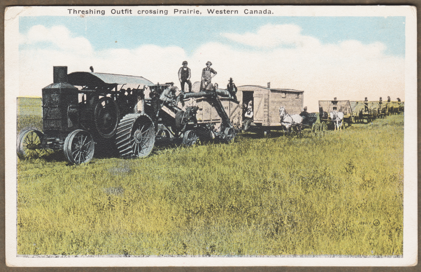
... The straw wasn't economical to transport very far to serve as bedding for animals in barns. However, this steam tractor is probably able to burn just about anything as fuel - including waste straw. 

Travelling at a very low rate of speed, these gangs would sometimes follow the harvest from south to north. Behind the tractor, the threshing machine and the cookhouse are being towed. The wagons would be used to haul the sheaves of wheat to a central threshing location on the farm - the wagon loading providing more work for the farm excursion labourers.

Without the practised finesse of their British cousins, you can see that the Valentine postcard artists have roughly cut off the image at the horizon and placed the subjects on a pre-made sky background.


*  *  *


Looking at the Google railway map of today, we can see that the stations west of Scott are ... Tako, Unity, Vera, and Winter. You can check AI to see if it can tell you which railway built through here. Or, if you know already, please feel free to make up your own joke about 'ChatGTP' and give yourself 100 bonus points!

This looks like a petroleum-burning tractor. Its belt-drive is transferring power to the almost hidden threshing machine via that huge, reinforced leather drive belt. All the sheaves are being transported here on the wagons. Workers then fork the individual sheaves onto the threshing machine's conveyor. After some mechanical magic, kernels of wheat flow from the machine into 100 pound bags - which you can see loaded on a buckboard wagon at the left. The straw is blown into a pile.

Hey Fellas! ... In the World of the Future ... they'll figure out how to bale straw and it will be sold at 'big box stores' charging $30 for 1/4 of a standard bale. Yeah, really! People will use the bales as front-door Halloween decoration ... in places called ... 'the suburbs'! 


The most important eliminator of that '98% of wheat farming labour' was automation powered by portable, powerful, petroleum. 

Horse-powered equipment provided only limited automation (cutting and binding the stalks). New petroleum-powered engines, moving petroleum-powered combine-harvesters ... would be able to operate through fields of harvest-ready grain. 

A powered combine had a greater capacity than the horse-drawn equipment (and the horses) so a farm's grain could be harvested when it was ready - in just a few days. On the dry Prairies, if there was no evening dew, the combine could work all night. The combine eliminated the need for separate binding, stooking and threshing operations.  

The combine also supported bulk handling of the grain - augering the grain into horse-drawn wagons. Eventually, the remaining labour of horse-husbandry to support horse-cultivation, horse-seeding and horse vehicle driving was made obsolete through the widespread use of petroleum-fueled tractors and trucks. 


from: Canada Handbook 1950; Dominion Bureau of Statistics.

About 50 years later ...

The image darkens into the book gutter at the left, but you get the idea.
A caterpillar tractor (rear, left) and a rubber-tired tractor (right) are towing two motorized combines.
Four workers are needed to harvest.


*  *  *

from: Province of Saskatchewan, Its Development & Opportunities; FH Kitto; 1919; Department of the Interior, Canada. 


*  *  *

The Wild Card ...


Kaiser Ferdinand's Northern Railway

... was the name that Salomon von Rothschild chose for the enterprise ... 
after he was granted the unlimited privilege from the Kaiser (Emperor) of Austria/etc. to build it.

The railway imported locomotives and support personnel from Stephenson's works in 1837.
(Similar to the motive power acquisition process of the Champlain & St Lawrence.)
This particular Vienna station (above) was built in 1866.
It was badly damaged in 1945 and its ruins were demolished in 1965.

The date of the postcard image and the map below are one year apart.
On the map, lines connecting city points represent railways.

Initially, the railway was to run from Vienna, into Moravia and Silesia for iron and coal,
and on to Buchnia (near Cracow in western Galicia) for salt.
Roughly, this route forms a gentle clockwise arc from Vienna around that yellow border of Hungary.

According to Wiki, the line was profitable by 1841 and the shares were above par two years later.
... Generally, securities were placed with the deal's underwriters at a discount to par (par = the face value of 100) 
before a public offering was made.

This example of this railway set off a local railway building boom.


from: Handy Reference Atlas of the World; JG Bartholomew; 1904; John Walker & Co.


15 September 2018

Interwar Rail Construction in Saskatchewan and Alberta, Part 2


This post is the second which looks at the ideas presented in the following paper:

Interwar Rail Construction in Saskatchewan and Alberta: An Evaluation

by Charles W. Bohi, Leslie S. Kozma

Presented at the Annual Meeting of the
Prairie Division, Canadian Association of Geographers in 2007

(Mr Bohi noted my interest in the area and emailed a copy.)

*  *  *

The link to my first post is below:

I actually found a link so you can download the research paper itself in PDF form:

The images I insert are not from the paper.
Square, indented paragraphs contain only my ideas or comments.
My brief account will only skim over some key elements of the paper.

*  *  *

Previously, the authors examined information related to the 1932 Duff Commission:

1. Why the Interwar branch lines were built.
2. Whether the CNR was the aggressor.

*  *  *

This post looks at the third and final question from the paper:

3. Was building these [Prairie branch] lines a 'Disastrous Mistake'?

Generally, the Interwar branch lines were constructed to serve Prairie farmers.
They were growing wheat - an important Canadian export.

As noted previously, a few of the branch lines were built for the purpose of providing transportation services to coal mines in the southern Prairies. As coal was a convenient fuel for space heating in the Prairies during this era, some of the branch lines shortened the distance it had to be moved - saving money for Prairie coal customers, including the wheat farmers.

Continuing with the theme of serving wheat farmers:

These Interwar branch lines included 605 locations
where the railways built sidings and other facilities to receive freight.

By 1936, 57 of these locations were incorporated as villages (50 people),
with 2 communities incorporated as towns (500 people).

In addition, 143 locations had permanent depots
(i.e. station buildings - with 'agents' to conduct local railway business).

The fact that almost one quarter of all locations saw station buildings erected
suggests that a significant amount of local commercial activity took place on these lines.

*  *  * 
A stretch of track we drove along ... as part of a vacation, and shown in another post ... the Fife Lake Subdivision, between Assiniboia and Big Beaver ... is examined in The Weyburn Region - see the References section of the 'Interwar Rail' PDF above. I could not find this Weyburn section in a readable form on the internet. Here are some of the authors' ideas on the Fife Lake Sub ...
from: CPR employee timetable; April 1950.

Atlas of Canada; 1981; Reader's Digest.

Considering the Fife Lake Sub example:

The Interwar branch lines were built to serve Prairie farmers. However, life for the farmers and their families had to consist of more than simply growing and transporting wheat. Using the Fife Lake Subdivision as an example ... the line brought in the essentials of life for those living in this area of Saskatchewan. This line also fostered social institutions and activities - and a sense of community - which softened the often harsh realities people faced in this area of the Prairies.

 In 1960, 68 cars of coal were delivered to the 8 stations on the Fife Lake Sub which had coal dealerships.

In 1969: 10 locations had post offices; 6 had general stores; 7 had gas stations; and Rockglen, the largest settlement, had a grocery store. Farmers could obtain bulk oil deliveries at 7 of the locations (farms often maintained their own bulk tanks with hand pumps for refueling tractors, combines, etc). Rockglen and Coronach also had lumber yards.

The communities on the Fife Lake Sub were also social centres - 6 had elementary schools, and Rockglen and Coronach had high schools. Churches were located at 5 settlements, and 5 settlements had a total of 8 ice rinks.

The following passage is taken from the research paper
and it portrays a time when the train was central to this community ...


*  *  *

from: Canada, A Geographical Interpretation; John Warkentin; 1968; Methuen.

If the railway branch lines had not come closer to the farmers, the farmers would have had to transport their grain by road using their own horse-drawn wagons ... or early rudimentary trucks - for the few who could afford them. Depending on the state of the grain market, this could have had a major impact on farmers' incomes.

As noted previously, the rural (often unimproved, dirt) roads were poorly maintained in the 1920s and 1930s and winter snow clearing was not provided until after the Second World War. (One source I read suggested that the Dominion Land Survey and its system of road allowances left farmers with an inefficient grid of too many roads which exceeded the local government's ability to maintain them.)

In the 1920s, the cost for a farmer moving a bushel of wheat 10 miles to an elevator was about 8 cents
Today it may seem that farmers were being pampered with expensive branch lines if they only had to travel 10 miles into town.
Keep in mind that 10 miles is the 'ideal maximum' distance which is often cited in historical accounts ... See the maps above. Horses at a walk, pulling a loaded wagon, travel at about 4 miles per hour. A 20 mile round trip would ideally take about 5 hours of travel time. 
... This would not include harnessing/unharnessing, resting or feeding the horses ... or waiting in line at the elevator ... or any delays or detours due to road conditions ... or time lost climbing steep grades at a slower rate which called for a brief rest of the horses at the summit.
In 1923 (a year of low prices), 8 cents per bushel for transportation to a local elevator was significant because the market was offering about 65 cents per bushel. Consider all the costs faced by the farmer to produce the wheat, and any debt and debt costs, plus clearing enough money from the crop to feed a family for the year, etc.

In the Interwar years, the Canadian government made the decision to assist farmers, and their efforts to produce wheat for export, in a reasonably economical way. The government supported the building of more railway branch lines through areas where farmers faced long road hauls to get their grain to market.

Eleven CNR branch lines (cited in a Senate debate in 1924) cost $9.5 million ... for 397 miles of line. They would carry about 10 million bushels of wheat and 2755 cars of other freight per year. It was calculated that they would save farmers on the lines $1.3 million per year.
Before changes to federal regulations which allowed the railways to abandon branch lines holus bolus in the 1990s (I believe) only a certain percentage of each system could be abandoned in a given year. Regularly, there was the solemn-faced submission by CNR and CPR officials of the following figures to the regulators ... for the branch lines they wished to abandon that year. 
GROSS REVENUE minus EXPENSES equals NET LOSS ... for the branch line.
... In conjunction with evidence presented to the Duff Commission (for 1923-1930) the CNR showed significant net losses for 10 specific lines. 

... However, the authors point out that the 'branch line freight cars' usually travel over the system OUTSIDE of the isolated branch line ... out where a railway's cost per ton-mile is lower. When one considers the whole freight movement ... which includes the more efficient sections of line (longer trains, heavier traffic per mile of track ... transportation 'in bulk') ... the net loss associated with the traffic originating or terminating on the branch lines is considerably less. 

... So, instead of being a 'disaster', the cost of the lines was more reasonable ... if the point was to encourage farmers to contribute to the nation's economy by growing wheat which was mainly for export. And that's what the government had been trying to do.

*  *  *

The Interwar Lines in 1935

When the last lines of this planned network were eventually completed ... in the middle of the Depression ... ecological problems (droughts, grasshoppers, topsoil loss), crop failures, and the Great Depression, itself, killed any enthusiasm for building more branch lines on the Prairies.


The authors provide these points for readers to consider:

  • The lines constituted 30% of the rail network in Alberta and Saskatchewan. 
  • The country elevator system reached its peak in the 1930s - about 29% of total grain delivery points were on the Interwar lines. 
  • In Saskatchewan and Alberta, 27% of all competitive points (where two or more elevator companies had country elevators) were on Interwar lines. 
  • From the 1931 census it was found that about 73% of all farms were within 10 miles of a railway station ... only 2% were more than 25 miles away.

In spite of the criticism levelled at the Interwar lines in the Duff Commission report, the authors point out that no wholesale abandonment of the lines was prescribed by Duff - i.e. to avoid throwing good money after 'bad'. In fact, these lines were subsequently key in the transportation of western grain for decades.

Abandonments for some of these lines were as follows:

1950s ... 115 miles
1960-1963 ... 370 miles
1963-1975 ... 525 miles
... As Prairie branch lines were being abandoned in the 1980s and 1990s, I remember a lot of local concern expressed that the infrastructure cost of transporting grain was being shifted from the abandoned lines to the municipal/provincial public highway system ...  as farmers preferred larger and larger trucks (not horse-drawn wagons) as the most economical short-haul method to the nearest surviving railside elevator.
Addressing some of the conclusions of later historians, the authors note that much of the rhetoric surrounding these lines during the 1930s originated from the general climate of bitter political animosity between the Conservatives and Liberals. The conventional wisdom was that the Prairie branch line system was overbuilt because of the actions of the CNR. In particular, Sir Henry Thornton (by then deceased) had been a cheap and easy target for the Conservatives.

Yet, in the face of this conventional wisdom, the Interwar lines continued to be useful ...

In 1963, using the 10-year average of 465 million bushels: about 25% of grain was still originating on the Interwar lines. 

The authors close with a nice (almost poetic) descriptive passage from a Queen's University economist in 1934 ... and I encourage you to download the PDF to have a look at it. 

*  *  *

End of my summary of

Interwar Rail Construction in Saskatchewan and Alberta: An Evaluation
by Charles W. Bohi, Leslie S. Kozma

PDF here:

*  *  *

Inspired by that last quotation, today, I purchased a copy of the 2015 biography of economist W.A. Mackintosh (1895-1970). Here is a passage from 1935 in which he describes the realities of farmers in the Canadian 'Wheat Economy' on the Prairies.

"The wheat farmer in western Canada is engaged in a business subject to unusually sharp fluctuations, imposed on it in greater or less degree by pronounced variations in rainfall and the other climatic conditions of wheat growing, and by the necessity of competing in a far distant world market for the sale of a raw material. In these facts of a commercial agriculture in which a high degree of variability is inherent will be found the centre of the economic problems of Western Canada."

*  *  *

from: Canada, A Geographical Interpretation; John Warkentin; 1968; Methuen.


from: Profitable Grain Trading; Ralph M Ainsworth; 1933; (Traders Press).


from: Profitable Grain Trading; Ralph M Ainsworth; 1933; (Traders Press).


from: The Canada Year Book 1934-35; Dominion Bureau of Statistics.


from: Canada Handbook, 1935; Dominion Bureau of Statistics.

08 September 2018

Interwar Rail Construction in Saskatchewan and Alberta, Part 1


Once I was on a VIA train to London with my boss as we headed for a hospital site visit. The director of another department happened to be on the same train and came over to sit with us. I commented about a 'stop and inspect' because we had tripped a hotbox detector ... and it turned out that the other director had had a relative in the running trades at Chalk River. 

Furthermore, she had just completed her master's degree and her thesis had examined the question:

Could the American west have been opened up without the invention of the railroad?

She said the answer was: 'Yes, eventually it would have been settled, but it would have taken longer.'

Railway building was/is capital intensive. Railways were the first major users of legal incorporation to facilitate raising that capital - and so they could securitize that investment back to investors. 

While a railway generally required low gradients, once the roadbed was prepared, the railway track structure provided an all-weather route on which one could pull long strings of self-steering wagons.

With the weight of the load distributed longitudinally over steel rails, and laterally over sturdy wooden ties ... railways were ideal for moving high-tonnage trains of bulk commodities in all seasons ... and anything else that would fit through the most narrow bridges, cuts and tunnels of its right of way.

Working to understand Canadian railways and how they have connected with the agricultural, economic, financial, political, social and technological elements of Canadian history can be a life-long pursuit. So much has been written and documented that one's knowledge will never be complete.

*  *  *

I was really pleased when my brother, Eric Gagnon, forwarded a study which Charles Bohi thought might be of interest to me:

Interwar Rail Construction in Saskatchewan and Alberta: An Evaluation

by Charles W. Bohi, Leslie S. Kozma

Presented at the Annual Meeting of the
Prairie Division, Canadian Association of Geographers in 2007

*  *  *

... I will attempt to outline some of the interesting information it presents ...
Indented paragraphs contain my own thoughts in passing.
The images inserted are not from the research paper.
I'll apologize in advance for my failures to relay key points precisely.

*  *  *

About 4600 miles of new railway lines were built in the Prairie Provinces between 1919 and 1935. More than 90% of this mileage was constructed in Saskatchewan and Alberta. 

In 1932 a Royal Commission on Railways and Transportation, referred to as the Duff Commission, was set up, under Chief Justice Lyman Duff (1865-1955). Its conclusion was that the construction of these lines was 'a disastrous mistake'.

Duff was the first Canadian to read the government's Speech from the Throne - March 12, 1931 - as the new Governor General, John Buchan (Lord Tweedsmuir), had not yet arrived. Buchan wrote The Thirty-Nine Steps and is credited with conceiving and promoting the idea of the famous 1939 Royal Tour of Canada. When Buchan died in office of a head injury, Duff again performed as Administrator of the Government until Buchan's replacement was sent over from Britain. Before becoming a lawyer, Duff had earned a double-barreled BA from the University of Toronto - this was in mathematics and (essential when dealing with the politically-tinged task of presiding over Prairie railway branch lines) metaphysics.
This blog post's alternate title could be: The Duff Commission: Math and Metaphysics

Consistent with the Duff Commission's conclusions, many historians studying railway lines of the Interwar period have blamed Henry Thornton and Canadian National Railways for the ruinous overbuilding of Prairie rail infrastructure.

To examine this consensus, the research paper analyzes:
  1. Why the Interwar lines were built.
  2. Whether the CNR was actually the aggressor.
  3. Whether building these branch lines was 'a disastrous mistake'.

Including the lines built by the Northern Alberta Railway, the new lines constituted almost 30% of the Alberta-Saskatchewan rail network.

It was after 1928 that 40% of these Interwar branch lines in Alberta and Saskatchewan were built. 

Here are some key dates relating to this review:
Mackenzie King, Prime Minister of Canada (Liberal) 1921 to 1930.
RB Bennett, Prime Minister of Canada (Conservative) 1930-1935
Duff Commission 1931-1932
Mackenzie King - second term as PM: 1935-1948
Sir Henry Thornton's term as President of the CNR: 1922-1932
Edward Beatty's term as President of the CPR: 1918-1943

*  *  * 

We when all get the time, we can actually read Duff's report ...


The website above may sometimes be down on weekends.

*  *  *

Duff noted that the Saskatchewan branchlines lines were through thinly populated areas (compared to the US, and Canada as a whole) ... Saskatchewan had 108 people per mile of line constructed.

In general, the Interwar branch lines constituted 41% of the Prairie's rail network but carried only 4.3% of all traffic.

There was 'no doubt as to the disastrous effects of this [branch line] competition'.

In 1932, to a large extent due to the Duff Commission's conclusions, most new construction of lines in western Canada stopped. 
As you know, after Conservative RB Bennett took power, the political knives were out for the Liberal-hired CNR President, Sir Henry Thornton and he was forced to resign - dying of cancer shortly afterwards in 1933 in New York City.
*  *  *

Question 1: Why were the lines built?

Political Pressure

In the west, farmers were increasingly focused on producing wheat for export and this constituted one of Canada's top exports through the 1920s and 1930s. Canadian-produced tariff-protected industrial products, including steel and farm equipment, were seen to benefit eastern Canadian business interests. Free trade with the US - for example to obtain cheaper farm equipment - would have benefitted western farmers ... and a Progressive 'protest' party developed in the 1920s (also running candidates in provincial elections) to promote policy changes. In the Commons, Mackenzie King required the support of these often free-voting Progressives to remain in power.

The restoration of the 1897 Crowsnest Pass Rate and the completion of the Hudson Bay Railway were both policies brought about through the pressures exerted on Mackenzie King's government by the Progressives elected at the federal level.


Economic Concerns

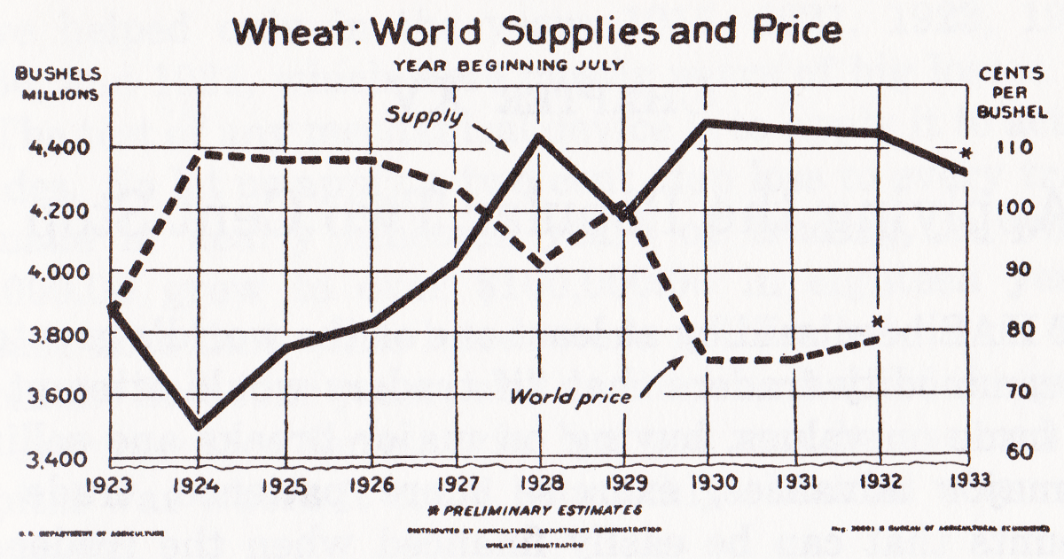
In the years before World War I, the opening of the west and the growing of wheat for export had had a strong effect on Canada's economic growth rate. After the war, as the result of a recession in 1921, wheat prices had dropped from $2.32 per bushel in 1919 ... to $0.76 per bushel in 1921.
33 bushels per short ton ... $0.76 in 1921 = $10.52 in 2018 dollars. 
King thought that continuing to encourage investment in railway and grain handling infrastructure would revive the economy. Farmers would have shorter distances to haul their grain harvest ... and domestic industries, such as steel making and BC's forest industry, would benefit.
Beyond lumber and steel, you can imagine all the diverse business and government activities which would be necessary to support such an economic expansion ... banking, farm equipment, tools, hardware, household goods, construction materials, retail services, religious institutions, schools.
The authors refer to the 'wheat economy' and much of this was driven by high immigration rates from Europe and the US. Many of these newcomers took up farming on the Prairies because of railway and government incentives.
from: Canada's Five Centuries; W Kaye Lamb; 1971; McGraw-Hill.

A representation of Saskatchewan's 'wheat economy' can be seen in the graph below. The 'oats economy' would have been more geared to the domestic economy ... as this was a key 'fuel' for the horses used in transportation and also for those working as draft animals on farms.

from: Saskatchewan - Its Development and Opportunities; 1919; Government of Canada.

Urban Rivalries

The 'wheat economy' resulted in increased economic activity to provide all the diverse goods and services it required.

With such a demand for goods, there was competition amongst settlements to develop into distribution centres. The ideal outcome was to become a railway junction point - perhaps connected with both railway systems. The classic example of a distribution centre is Winnipeg.

From population centres to settlements farther and farther afield, salespeople fanned out (initially by rail) to contact the retailers and citizens who needed their products.  Freight buildings and warehouses are most efficient when located centrally and when goods can flow out along roads or rail lines to customers in the hinterlands beyond.

The authors cite Camrose, North Battleford, Prince Albert, Estevan and Weyburn as towns aspiring to benefit from new branch lines which might have increased their importance as wholesale distribution points serving larger and larger hinterlands.
One western geography I have been reading suggests that the cities which have grown significantly in the Prairie region were those around its edges: Calgary, Edmonton, Winnipeg. It was suggested that vast distances and the traditionally light distribution of population engaged in agricultural activity along the railways had produced this pattern  - which has largely remained unchanged.

from: Canadian National's Western Depots; Charles Bohi; 1977; Railfare.
A Canadian Northern Railway train circa 1905.


... continuing to examine why the branch lines were built ...

Vast Areas Not Served

One of the examples the authors cite was the Canadian Northern - which had few branches north of its mainline ... in the area west of North Battleford. Consequently, grain growers north of the North Saskatchewan River had long distances to haul their grain and a river to cross before they reached a country elevator.

Another example related to the CPR - which had nothing south of its existing line between Weyburn and Assiniboia. (This area provided the setting for one of our most interesting vacation trips - when we looked at parts of the Fife Lake and Bromhead Subdivisions ... which had been built into this unserved area.)

We are reminded that after World War I farmers were using horse-drawn wagons or sleds to haul their grain. The 1931 Canadian census noted that 97% of the farms were on improved or unimproved dirt roads. The condition of Saskatchewan's rural roads deteriorated during the Depression. These roads were not maintained in the winter until the mid-1950s.

As suggested above, natural features like watercourses (which often had to be forded), ranges of hills, and valleys were major obstacles for farmers moving their grain.

In the 1920s, citizen-owned cars and trucks began to cut into the passenger revenues of the branch lines' often thrice-weekly mixed train schedules. However, there were only 18,257 trucks in service by 1931, while there were 225,000 farms in Alberta and Saskatchewan. Grain was still moved largely by horse ... even if people often chose the convenience of autos over rail for travel between settlements.

With the reintroduced Crow Rate, farmers had a strong incentive to lobby for country elevators to be as near to their farms as possible.

Consider the 'human experience' of farmers in the 1920s ... You can imagine a team of horses working to pull a heavy steel-wheeled wagon (or sled in winter) of grain over all the obstacles described. The load would have been calculated to just make it to the top of the steepest hill, or through the most difficult ford, based on the environmental conditions of that day.  
From all over the catchment area of a country elevator, each farm would be dispatching these small, slow, inefficient movements of grain over and over with an empty backhaul on the return trip.
... Contrast that system with the efficiency of hauling that same quantity of grain over a newly-constructed branch line: Bridges crossed the watercourses; Cuts and fills carried the grain through the hills and over the valleys; Farmers, their family members, and their hired hands spent less time behind horses on dirt roads.

from: Western Canada, Canadian Pacific Railway; prob 1909; CPR 

*  *  *

Question 2: Was the CNR the Aggressor?

The CNR built into 3570 square miles of CPR territory.

The CPR built into 4500 square miles of CNR territory.

Coal is one type of non-agricultural traffic which both railways were often keen to compete for.
... In addition to being used as fuel for steam locomotives, and for industrial and domestic heating and steam production, coal was also used for the production of town gas and coke. In rural areas of the Prairies, where firewood was not available or economical to use, coal was used for domestic heating. The authors note that many small Prairie centres had coal dealerships.
Probably the most coveted and most lucrative freight was LCL - Less Than Carload. (During my father's work in the CPR Department of Freight Receipts at Windsor Station in Montreal they said 'Less Carload' ... maybe CPR docked employees for lost time if they added 'Than'.) Typically, LCL would be a boxcar containing freight from more than one shipper ... destined for a number of consignees at a given population centre. Freight buildings were built at these centres to receive, document, store and distribute the foodstuffs, hardware, household goods etc  received. Often bulk commodities would be received at an industry spur or railway team track (again, we refer to horses).
Express traffic and federal mail contracts also bolstered railway profits and took some of the sting out of hauling the area's agricultural commodities.
The authors provide abundant local geographical evidence regarding particular routes built by both railways to particular centres - which is beyond my ability to explain adequately. 

The authors write that Henry Thornton was often 'reasonable' about the location of new CNR lines and granting trackage rights to the CPR.

In contrast, the CPR often aggressively defended its territory and its own population centres with counter-construction - to block the CNR and/or to spoil the profitability of the unserved territory into which the CNR might build. The CNR tried to build lines reaching CPR centres such as Swift Current, Red Deer and Medicine Hat but was effectively rebuffed.


Below, I attempt to illustrate only a few simple examples which are cited in the research paper.
The authors are very thorough and exact in their documentation of the actual
context and progression of events - which I am not attempting to reproduce here.

(Regular readers of this blog long ago gave up any expectation of seeing academic rigour!)


The maps are taken from: Railroad Map of Western Canada; no date - 1950s?; Canadian Freight Association.

We can only infer that track or stations represented in black are joint operations between CNR and CPR.


 CNR built a line toward Swift Current.

CPR countered by building to Stewart Valley ...
with the implication of building a bridge and line to reach Matador - which was never built.
*  *  *


CNR would have built to Medicine Hat, but CPR would not grant trackage rights within the city.
CPR maintained its monopoly in southern Alberta including the Lethbridge area's coal traffic.

*  *  *


CNR granted trackage rights into Prince Albert and North Battleford.

CPR built freight stations in North Battleford, Humboldt and Prince Albert, 
but shared passenger facilities with CNR at these locations.

North Battleford is a junction northwest of Saskatoon.
Humboldt is a junction roughly east of Saskatoon.

*  *  *

The CPR built more than 700 miles of track north of the CNR's Yorkton SK-Saskatoon-Wetaskiwin AB line.
To see that area on the map above, follow the blue CNR line from the southeast corner of the map 
to 'Artland' in the orange Saskatchewan-Alberta border area.

*  *  *

The authors list the following centres as being invaded by the CPR after World War I:

Saskatchewan: Humboldt, Lloydminster, Melfort, North Battleford, Prince Albert, Tisdale.
Alberta: Vegreville

1931 data for the seven centres
Total population: 23,843
Retail trade: $26,903,500

*  *  *

from: Imperial Royal Canadian World Atlas; ed: Fred James; 1935; Geographical Publishing, Chicago.

*  *  *


The Drumheller coal region includes that area of black 'joint stations' to the northeast of Calgary. 

Before the CNR, the Canadian Northern in 1918 had double-tracked Munson to Wayne 
to handle the heavy coal traffic (up to 30 trains per day).

CPR received permission from BRC to build into these coalfields in 1919.
CNR eventually allowed trackage rights and built a joint line south from Rosedale to East Coulee.

The authors cite this as 'the most serious CPR incursion into CNR territory in Alberta'.

*  *  *

Question 2: Was the CNR the Aggressor?

"Given the CPR's aggressiveness and the CNR's willingness to cooperate with it by granting trackage rights into major trade centres, the charge that the CNR was the aggressor in the Interwar construction of branch lines is not supported by the evidence."

*  *  *

Thanks to Charles Bohi for sending me these Big Beaver photos.

Additional Charles Bohi photos of Big Beaver track and elevators, 
and Coronach and Rockglen stations,
can been seen in these posts:


Big Beaver, SK#11, Paterson Elevator, Look NE, July 1984, Bohi Photo


Big Beaver, SK, End of Track Fife Lake Sub. Supposed to be connected to Bromhead Sub at Minton, Look SW, July 1984, Bohi Photo


Question 3: Was building these lines a disastrous mistake?

... in the next post ...


03 September 2016

Canada 1925 - to school, to harvest


Currently being a little bogged down in a post with more moving parts, I thought this would finally be a good time to post some images from a very worn and defaced textbook my father used as a child in the 1930s. 

Both of my father's parents were in the 'family business' of education in Quebec and mainly in Montreal, as was my father. His sister became a nurse and had a very broad range of health care experiences. 

As this is being posted, kids are looking forward to - or dreading (my approach) - their imminent return to school in 2016. About century ago, my grandfather would have been in preparation for teaching some of his first classes.

The source for this post is actually a geography text from 1925. Considering the rural/urban population distribution of North America back then, it seems appropriate that there are so many illustrations of agriculture in the west and the export of grain. Train images are scarce, however.

... Bringing more family into this piece, my uncle from Portage la Prairie was recently involved with a threshing record at the Manitoba Agricultural Museum at Austin - using the same general type of equipment seen in the following illustrations  - 140 threshing machines built between 1887 and 1953 were used to set the record in July 2016. 

Although Canadian grains today are generally bred to mature sooner and are Roundup-harvested early ... we could imagine the harvest operations shown in the images with the circa 1900-1920 cultivars which farmers were hoping to get in before they became frost-damaged.

I have included a few key pages of text ... they explain the book better and they also provide some interesting historical detail about the population of Canada's and the world's urban centres during that era.


This text is adapted for Canadian students from the original American version. Other editions of this same book, from around this era, can be seen at archive.org .

The original images in the book are usually only a couple of inches in size. In enlarging them, the dithering, engraving details, etc are made a little more pronounced. I have avoided the temptation to blur the pixels so the characteristics of the original 'artifact' come through. 


The topography often lent itself to the cross-country transportation of crops and contract harvesting equipment.


This almost looks like a hot bulb, 'hit and miss' engine - similar to those used to power early grain elevators.


Large operators could afford steam tractors.

*  *  *

This placeholder represents seeding and the growing season.
(Apparently these were too boring to show to school kids.)

*  *  *

A gang of horse-drawn binders are cutting the mature grain stalks and binding them into sheaves.
In this book, vertical lines on a horse's body usually represent a light-coloured horse - not underfeeding.


The sheaves of wheat are propped against each other to form a stook ... with the grain end in the air to protect it from ground moisture ... more specifically, from: rot, molds and fungi. Ground-level rodents are likely to get their fill from the lost grain seeds they can access on the ground - so there is a degree of rodent protection as well.

The process of threshing - striking the grain stalk to separate the grain seed from the stalk, and also the proverbial chaff - requires grain plants of low moisture content. Broken up bits of the grain flower and the shattered hollow and dried grain stem tend to be lighter than the grain seed itself ... and traditional winnowing ... and modern threshing machinery ... used these physical characteristics to achieve the separation of the grain.


Once the sheaves are dry and threshing time is near, a labourer with a pitch fork fills a wagon and the sheaves are taken to the threshing machine. 

You can understand why the railways, during this era, ran 'harvest specials' in the fall to take unskilled and semi-skilled labourers west to help with the harvest. There was a lot of sheave-handling to be done.

In contrast, a modern 'combine harvester' cuts and threshes the dried plant stalks as it makes a single pass over the plants. An auger on the combine transfers the grain to a truck for hauling to an elevator for storage.


At the threshing machine, the gathered sheaves are fed into the machine's conveyor.

In eastern Canada, a horse on a treadmill might power the threshing machinery.

In western Canada, with so much grain to be processed, usually a steam tractor transferring its power via a large belt, powered the thresher. 

Here, the grain is augered to a worker on the wagon at the left - who bags it. The straw and chaff is put into a pile on the ground.


At the steam tractor, a horse-drawn water tank is used to fill the boiler with water. For fuel, steam tractors were omnivorous - in an ecologically virtuous cycle, they could burn waste straw, if desired.

You can see the long belt transferring power to the thresher.

Although people probably ate more oatmeal/porridge then, oats were fed to cattle, but they were particularly important for fueling horses in both the country and the city.


The wheat is being dumped, weighed and graded.
Large wheat seeds, undamaged by frost, rot and plant parasites were more valuable.

Wheat from each rail car was sampled and officially graded by government inspectors as the boxcars passed through Winnipeg. This grading governed how the still-travelling boxcars, containing the government standardized grades of wheat, were to be handled as they arrived at the terminal elevators. The highest quality wheat would be segregated in particular bins in the terminal elevator, etc.

Steam-powered ocean ships required specialized hull construction to avoid damage in ocean storms. In addition, extra space for fuel was part of the design, because thousands of miles had to be travelled before the next supply of coal was reached. Ocean ships were not economical to bring past the ports of Montreal, Quebec City and the other locations where large terminal elevators served ocean ships. River ice also meant that Montreal, Quebec City and similar St Lawrence ports could not be used during the winter and early spring.

Lakers for use on the Great Lakes could be built as large as the smallest lock they were to use, with little concern they would ever see ocean-sized storms. Smaller canallers were of specialized dimensions - depending on which of the canals they plied. Lakers and canal boats could count on frequent re-coaling opportunities on their routes as they waited for their turn through locks etc ... so little cargo space was lost to coal bunkers.


In winter, it would be necessary to use sleighs.
... Come back and ask again about comfort then.


My brother forwarded to me this information from Jason Paul Sailer ...
The Galt #6 Mine was in operation in North Lethbridge from 1909 to 1935.

This extinct design of boxcar could be used (as shown) for bulk commodities such as coal, or grain.