Showing posts with label St Thomas Ontario. Show all posts

12 July 2024

St Thomas - The Railway City, Postcards x5

About 40 years ago, we took a vacation trip to St Thomas, Ontario in order to take a train ride on the Port Stanley Terminal Rail. 


Starting with that visit, I resolved to someday master the long and interesting history of all the railways in The Railway City. As we wait for that day to finally come ... please enjoy these postcard views.

In the course of preparing these images, I noticed that these five postcards were all published or mailed between 1906 and 1910.

If you are not already a St Thomas expert, a topographic map from 1909/1913 is provided at the end and it identifies the lines of all the railways passing through the city at that point in history. 


* * *


This postcard is completely 'delaminated' ... so I'm guessing it was not stored in a cool, dry place for all of its life. The little cabin (in the foreground) which may have been for a signalman ... who was responsible for operating the interlocked semaphores ... protecting the railway crossing at grade (the diamond) ... is interesting. 


*  *  *


Based on its serial number, this postcard was published circa 1908.

Typically, a large station with an equally large second storey might house the offices of a railway 'division' and the superintendent who oversaw it. A smaller second storey might be the location of a regional dispatching office. 

A divisional office would often include departments which handled payroll - as the railways of this era were very labour intensive. Another important department processed the paper necessary to send loaded cars to their destinations and empties to where they were requested. As the standard gauge railways formed an integrated North American system ... these car control clerks would also apply the rules governing interline and international freight cars and the loads they were transporting. 

In many cases, the second storey would house a regional dispatching office ... where staff who were highly skilled in the application of railway operating rules and telegraphy would control traffic over several 'subdivisions'. Via telegraph or telephone, these dispatchers would issue elegant, seamless and binding movement orders to [telegraph] 'operators' in stations up and down the line for delivery to, and action by, train crews.


*  *  *


... speaking of St Thomas stations with second storeys ...


*  *  *


Water towers, coaling towers, ashpits (into which locomotive coal fires were cleaned), rolling stock maintenance and repair shops, passenger and baggage & express services, maintenance of way (track and roadbed inspection and repair) ... are some of the items shown in this postcard which would have employed the citizens of St Thomas.


*  *  *

Here is the map to show the extensive railway facilities of St Thomas circa 1910.

A section of the St Thomas sheet. Year: 1913, Sheet no. 040I14 [extract].  from: Historical Topographical Map Digitization Project.  https://ocul.on.ca/topomaps/collection/

The 'Canadian' line between Adrian (in the north-east) and St Thomas is a Canadian Pacific branch line.

So you can enjoy deciphering all the features of the railways through St Thomas, 
the map key is consolidated and reproduced below.


A section of the St Thomas sheet. Year: 1913, Sheet no. 040I14 [extract].  from: Historical Topographical Map Digitization Project.  https://ocul.on.ca/topomaps/collection/


28 October 2020

St Thomas, The Elgin County Railway Museum in 2000, Interlockings


We made a number of visits to St Thomas over the years. 

We particularly enjoyed this visit 'at the turn of the century' 

during a celebration of the local railway heritage.


Live steam locomotives were featured..


from: CNR employee timetable 51, Southwestern Ontario Area, October 1973

This elegant employee timetable map shows St Thomas within the CNR network.


from: Atlas of Canada; 1915; Government of Canada.

Railway territories are shown in this federal map of the railway lines circa 1915.
Consistent with local tourist lore, I think you can see the five railways of St Thomas.
The US lines owned/leased these fast shortcuts north of Lake Erie as part of their larger networks.


Essex Terminal Railway Company, Engine 9 (MLW 1923).
There was too much to see, so we didn't ride this time.


The substantial two-storey station once belonged to the Canada Southern, 
the route of which is shown as Michigan Central on the map above.


Above: You can see one of a small group of hostlers and 'watchmen' who were attending this locomotive as it simmered here during our visit. 

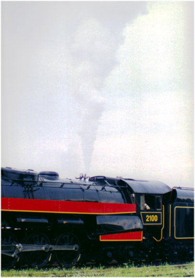
I think Reading 2100 was owned by Tom Payne at this moment in history. It had been designed to burn anthracite coal, but was converted to oil - an easier fuel to procure and handle at the turn of this century.

According to 'the internet' oil could not provide the concentrated heat of anthracite and the locomotive was deemed to be a candidate for conversion back to coal so it could be used economically in passenger service.


... Nonetheless, this kept happening.


On the west side of the shop, here is some of the specially-marshaled rolling stock for this event. There were speeder-trailer rides offered to the east and west at the same time on a particular track. Riding an unsprung trailer on bolted rail was a little rougher than a Turbotrain ride. 


The location of the transfer table can be seen here at the east side of the shop.


The GTW (Port Huron built) caboose owned and restored by Ross Robinson at the Smiths Falls Railway Museum was displayed ... and showing the great care he took to see it preserved, restored and finally housed indoors. It had arrived during the previous year or so. 

It was difficult to get a 'long shot' of the caboose inside the shop. The carefully-matched Morency orange is 'off' a little in the photo because I fiddled with the exposure so you could see the archbar trucks. At any rate, I tried to take a few photos to give to Ross if only to acknowledge all the work he did to prevent the car from being burned in Toronto - with only its metal hardware saved from the remaining ashes.


On February 17, 1991 my father and I made a trip up to Smiths Falls to commemorate 
the 100th birthday of Ross Robinson's GTW caboose - as Ross was away at San Diego.
It was a crisp, cold winter day. I mailed a copy of this photo off to Ross.

With characteristic humour and exaggeration Ross said some of the Americans were amazed !! 
Did we need to use a specially-heated camera to get the photo under those winter conditions?!  etc, etc.


This CNR employee timetable gives you an idea of some of the local railway features of St Thomas.


A local roadmap appears below to show more detail. 
The shops occupy the streetless area between Wellington Street and Talbot Street/Highway 3.

West of the shop area:

BX Tower (not shown on the map, but you can see some of 'its' tracks) is located just north of the intersection of Moore and Centre Streets. Its rectangular hip roof can be seen on the Google Maps satellite view in 2020.


from: London, St Thomas roadmap, Rolph-McNally, no date. Purchased circa 1985.


Taken from a caboose cupola, we are taking a 'shuttle' over to BX Tower 
- at the right side in the distance.

It is described in the Talbot Subdivision timetable footnotes of the employee timetable above.


At BX Tower:

Our shuttle was pulled by Wabash 51 - a 43 tonner, built by GE in 1939.
This view looks east and you can see the Reading engine, etc.


Above and below, at the operator level of BX Tower.
Above is the operating side of the levers, along with our guide.

Below is the back side of the rack holding the levers.


We were shown the mechanism in the level below this, but a good photo was not possible.
The levers are colour-coded by function ...
e.g. lock, switch, signal etc.

There are excellent YouTube videos which interpret preserved 
British interlocking towers (aka 'signal boxes').
Some of them also had separate levers to apply 'fog signals' (torpedoes) to the tracks.


*  *  *


Photos of British Interlocking Systems


from: Railways in Camera; Robin Linsley; 1996; Alan Sutton Publishing.
Stratford Central Junction, UK, photographed in 1912 


... While BX [interlocking] Tower didn't show any evidence of electrical gear, the British 'signal box' above shows some. 

As a generality and as I understand, British steam locomotives used lanterns placed in different locations on their pilots to convey type of train and route/destination. Of course, operators would expect the daily trains at particular times and their centralized train dispatching bosses would control the big picture.

The signal boxes (including the one above) would have simple 'telegraphs' connecting them to the next box 'UP' (toward London) ... and the next box 'DOWN' (from London). 

Some early Canadian railways (e.g. GTR) also used the UP and DOWN system before the cardinal compass directions were written into the rulebooks and employee timetables.

Signal box 'telegraphs':

A bell circuit enabled a tower to initiate a call to an adjacent tower. When the distant tower answered back with the same bell signal ... a traffic request would be made with another bell signal. If concurred with, the adjacent tower would repeat that traffic bell signal back. A series of needle telegraphs would be used to communicate block occupancy between towers.

The paramount safety task of the signal box was to prevent a train from blasting by, and along the track beyond, before the next signal box indicated that the last train sent had cleared the block. 

... There were rules to handle trains delayed for an unknown reason within the block and other exceptions to smooth operations.

The 'local autonomy' given to signal box operators is an interesting way to efficiently move traffic along a railway. It contrasts with the North American model where the dispatcher is often styled as a great military commander planning hours ahead, sending written telegraphic orders to 'his troops' in the field. 

... I suspect this was due to the mainly 'single track through wilderness' infrastructure of North America. In contrast, the UK often had separate UP and DOWN lines, as well as stretches where there were Pennsy-style dedicated fast and slow tracks in each direction as well.

As Stratford UK (above) was a junction, one would expect at least 5 tracks to be converging on it from 3 or more compass directions ... so it is quite an operation. If you check the 'Stratford Station' (for the city near London) UK entry on Wikipedia, you'll see an interesting map of the local railway lines from 1914.

Often interlockings (e.g. Westmount, Quebec) governed movements around coachyards and passenger stations with multiple tracks.

I did a few pieces on the international development of telegraph signalling and the post linked below elaborates a little on this era of telegraphy.


*  *  *

from: GWR Company Servants; Janet KL Russell; 1983; Wild Swan Publications.

Both photos: 

At the Reading signal works of the Great Western Railway, UK, a signal box locking frame in construction for Aber Jct in South Wales.

I only have the upstairs views of BX Tower at St Thomas, but here you can get an idea of what was downstairs. Essentially, these railway signal workers are doing 'in house' computer 'logic programming' with metal. On both photos you can see a supervisor with a paper plan of how the algorithm and its language should go.

... from the Standard Code of the Association of American Railroads (AAR) in 1897 ... 

"Interlocking: An arrangement of switch, lock and signal appliances so interconnected that their movements must succeed each other in a pre-determined order."

... by 1938 ... the AAR Standard Code language had changed to include that an Interlocking could be operated manually or automatically.


from: GWR Company Servants; Janet KL Russell; 1983; Wild Swan Publications.

While the photos above do not show the linkages in detail, you can get the idea that this was a very complex logic machine ... which would then be connected to metal systems of rods, levers and cranks to actuate switches and signals far beyond the confines of the signal box at Aber Jct, South Wales. 

In contrast to today's computer programming for standard hardware, a significant amount of mechanical engineering technology skill would be necessary to ensure that all the mechanisms operated smoothly as built here ... and when installed in the field ... to ensure consistent operation and necessary safety redundancy. 

... There was generally a very specific prescribed sequence of lever operation to get a train from point A to point J through the interlocking. Locks, switches and signals were actuated along the planned route of the anticipated train movement one after the other until the operator had everything lined.

... Experienced interlocking operators (and maintainers) would develop an intimate knowledge of the operation and idiosyncrasies of their local equipment - particularly in all types of weather.


*  *  *

From Jim Christie came a reminder of this fabulous article.
It shows how old interlocking towers were modified
to take advantage of advances in electronics.


*  *  *

Further misadventures during our earlier visits to the St Thomas area can be seen through these links.


Near London in 1992 and the Loop Line Transfer


22 May 2016

C&O 1985 St Thomas, Ontario - Roundhouse


In 1985, in the distant dark ages before the internet, we were visiting the railway attractions of south-western Ontario. These attractions were discovered from paper publications such as Trains magazine and Canadian publications such as Canadian Rail, Branchline and the UCRS Newsletter. Our male family members maintained a small paper internet and library with 'postings' once or twice per week. 

... and when the first personal computers were available in the late 1980s, we'd do things like index my father's 20-year collection of Canadian Rail 'for fun'. 

In any case, during our first visit to St Thomas my spouse and I came upon a surprise ...

On a GoogleMap image from circa 2016, you can still see the imprint of 
the former Chesapeake and Ohio roundhouse, turntable and shops at St Thomas, Ontario.
North is at the top of the image, as it is for the map below.


from: London, St Thomas roadmap, Rolph-McNally, no date. Purchased circa 1985.
With the street names on the aerial image, above, matching up with the map below it, see if you can spot the location of the former roundhouse. The answer is just below.

We purchased this map around the time of our visit. Railways in St Thomas and the local layout of roads were challenging to master when we visited for just a few days on vacation. Our navigation achievements could not always be reproduced on demand - even for something simple like getting back to our motel.  We made three trips there over the years. 

Answer: Look for the track wye in the south-west corner of the map. Wilson and Elm Streets meet near the blue triangle. Notice the London and Port Stanley line is labelled, running almost straight north and south.


The sanding facility is left at the very edge of the photo as a landmark for you.
Perhaps the first item to attract our attention was the brightly-coloured Chessie System power 'deadline'.


The Baltimore and Ohio Railroad was eventually controlled by the C&O in 1963.


A transfer table formerly used at the shop facility.


The roundhouse building.
You can see the sanding facility and the locomotive deadline at the right.
I think the top 'absolute' arm of the diamond semaphore governed London and Port Stanley traffic.


Some detail of the roundhouse turntable can be seen here. The black cabin was occupied by the hostler or labourer operating the turntable. Electric power is fed to the centre tower on the turntable bridge. The electrical contact point remains static while everything turns beneath it. 


How many treasures can you stumble on in one spot?
A steam auxiliary crane beside the roundhouse.


With the steam crane's green idler car closest to the camera at the extreme left, here is a final overview. There were so many other things we were scheduled to see in St Thomas, and there was no question of trespassing more than we had to take these pictures - so everything was photographed in a matter of minutes. During our next visit a few years later, only building wreckage was to be seen here.

According to Engine Houses and Turntables on Canadian Railways 1850-1950; Edward Forbes Bush; 1990; Boston Mills Press ... Pere Marquette (C&O) built this eight-stall roundhouse in 1941. The turntable was 115 feet long, the stalls were 120 feet in length. This modern, long turntable reflected the size and power of the locomotives used near the end of steam.

... In that earlier era of protective tariffs on railway locomotives, to ensure that this high tech industry remained in Canada - locomotives tended to operate, and to be serviced, on one side of the border or the other.

*  *  *

The next few images and maps show the Pere Marquette Railroad - reorganized as the PM Railway in 1917.
The Pere Marquette was merged with the C&O in 1939 and amalgamated on June 6, 1947.

from: The Picture Gallery of Canadian History, Vol 1; CW Jeffreys; 1942-1951; Ryerson Press. Collection of LCGagnon

Pere Jacques Marquette was sent to New France as a missionary at the age of 29 by the Jesuits. After other explorations, he and Louis Joliet explored down the Mississippi. Being concerned that they might tangle with the Spanish if they continued farther, they turned back. Weakened by dysentery, Pere Marquette died at age 37. 


This postcard was mailed to Guelph in 1909. You can see many little details here. Perhaps local railway officials at the crossing are watching the photographer risk his life on a perch such as a coaling tower. This view may be from the west switch of the wye pictured in the 1985 St Thomas map, above ... with the pre-electrification London and Port Stanley running somewhere in the background near the shop buildings.

from: Atlas of Canada; 1915; Dominion Bureau of Statistics.
With the railway territories mapped out in my favourite atlas, here is the complicated arrangement in south-west Ontario in 1915. Being good economic geographers, the American railroads built or acquired railways in Canada along the north shore of Lake Erie because the route was shorter (e.g. from Buffalo/Niagara Falls to Detroit) than travelling around the southern edge of the lake. Back in the time when speed provided a competitive advantage for passenger, express traffic and freight, this arrangement made sense. Some of this was very fast track. 

As the 'free' highway system developed, passenger traffic, and time-sensitive freight travelled more and more by road. Fewer railway lines were needed for the remaining bridge traffic through the area, and to service local industries. Government regulation had preserved service on some of the lines and facilities we saw in St Thomas, but many had become mementos of the railways' past achievements.


from: Atlas of Canada; 1915; Dominion Bureau of Statistics.
Here is the same map with better detail from St Thomas to the west.
I had to do the images as video captures because that book gutter at 'Windsor' was impossible to reproduce on the scanner.
Along with this map, the Atlas of Canada stated that the Pere Marquette had the following in Canada: 
359 miles of track
55 locomotives
30 passenger cars
2157 freight cars
No date. Card printed in Germany.
In 2016, I believe you can see this location restored in a durable way, using the original ferry ramp beams and counterweights near the intersection of Goyeau Street and Riverside Drive East at Windsor.

from: Official Guide to the Railways; 1915; National Railway Publication Co (reprint), Collection of LCGagnon.
Above is the railway's own system map in the Official Guide of 1915. With the lack of detail shown east of St Thomas, and also in the timetable following, you would be correct in assuming that the Pere Marquette had only running rights east of St Thomas. The exaggerated directness of railway routes on this type of map really illustrates the attractiveness of the Canadian route north of Lake Erie. Competitors' lines are shown only if it is advantageous for the railway commissioning the map.


from: Official Guide to the Railways; 1915; National Railway Publication Co (reprint), Collection of LCGagnon.
*  *  *

Jumping from 1915 to the world after 1941 ...


from: Upper Canada Railway Society Newsletter, April 1989. Courtesy of Eric Gagnon.
In our photo album is preserved this excellent image forwarded by my brother near the time of our visit. Two tracks and the catenary of the London and Port Stanley run behind the new Pere Marquette/C&O roundhouse. Four rails of the transfer table shown above can be seen beyond the large, flat shop building. An old wooden passenger car with a clerestory is visible on the far side of the transfer table tracks.


from: Handbook of American Railroads; Robert G Lewis; 1951; Simmons-Boardman Publishing Co.
In this reference handbook, along with the C&O system map above, was an overview of the railroad, including the following passage:

"Chairman of the Board is Robert R Young, born 54 years ago at Canadian, Texas. Mr Young achieved popular fame by advertising that a hog could cross the country without changing cars while a passenger could not."

If you have gained nothing else from this post, at least you have a reference for that famous quote and observation regarding the corporate and physical development of the American railroad system.


from: Atlas of Canada; 1957; Dominion Bureau of Statistics.
With other forms of transportation becoming dominant in the 1950s,
the railways of south-west Ontario were shown in much less detail in the 1957 Atlas of Canada.