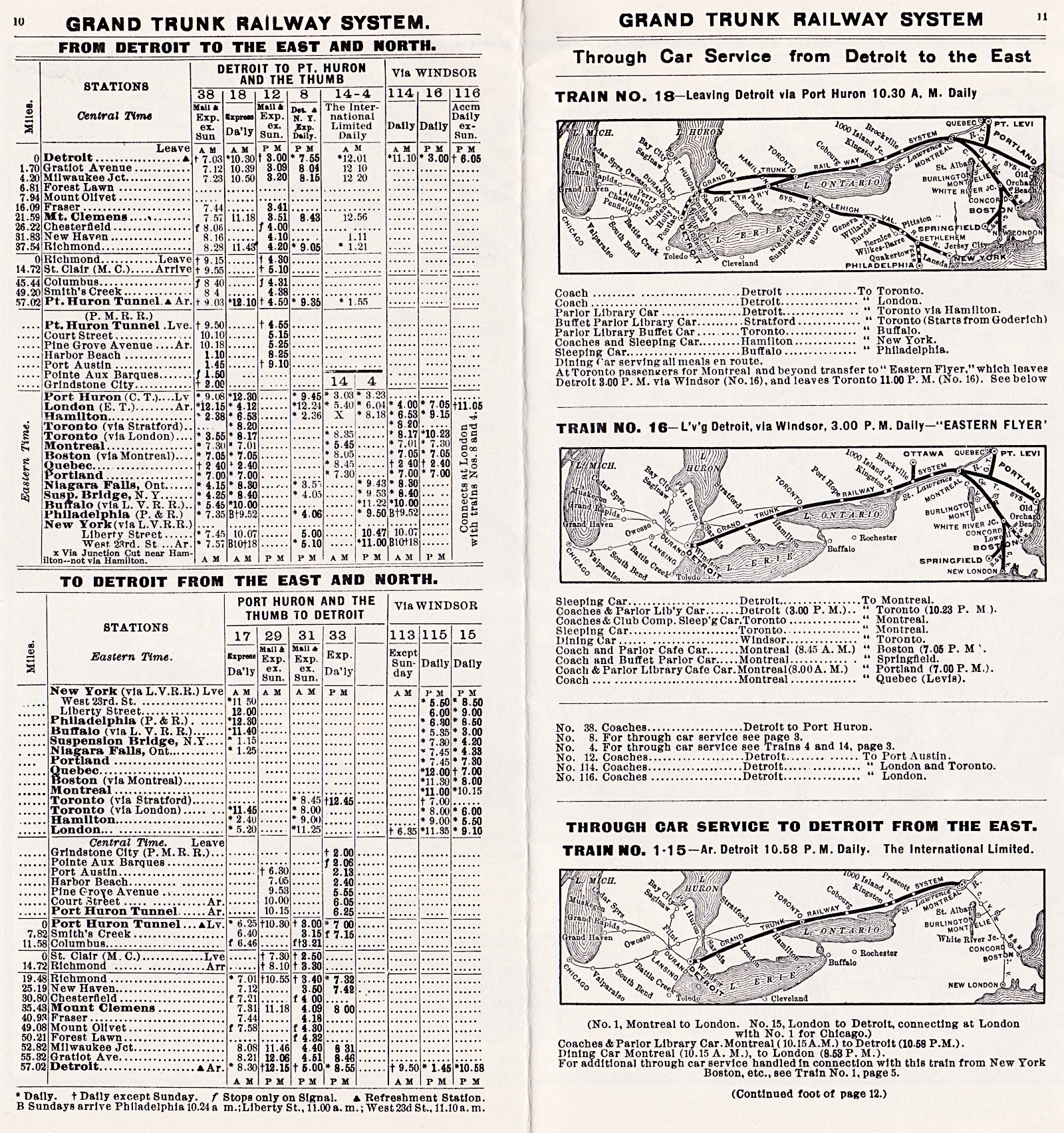
A great amount of detail and the original continental strategy of the Grand Trunk are shown in this reprint by Railfare.
Portland-Montreal-Toronto-Sarnia
First, the Grand Trunk joined the principal cities in today's Quebec and Ontario with a year-round American seaport ... the cleverly-named Portland, Maine. These objectives were completed by construction and railway company acquisition.
... Next, the Grand Trunk worked to develop a connection to the prosperous, expanding American west. Chicago was developing into a key railroad hub.
Sarnia-Port Huron-Detroit
Grand Trunk railway car ferry service between Sarnia and Port Huron, Michigan began in 1859. A railway connection between Port Huron and Detroit was built and opened in 1859.
The St Clair River Tunnel (Sarnia-Port Huron) was opened in 1891.
Detroit-Chicago (via MCRR)
Following the Port Huron-Detroit routing, the Grand Trunk operated over the Michigan Central from Detroit westward to reach Chicago.
Port Huron-Chicago ... GTR
The Chicago and Grand Trunk Railway was formed in 1880 to consolidate short lines and construct 34 miles west of Valparaiso, Indiana. This finally provided the Grand Trunk with its own access to Chicago.
 |
| from: Grand Trunk Western; Patrick C Dorin; 1977; Superior Publishing. |
An eastbound Lehigh Valley train, with Grand Trunk motive power, pauses during its trip from Chicago to New York.
Today this building can be seen at 175 Main Street, Battle Creek.
The photo was taken circa 1915.
Probably using a pre-positioned, large-format camera to photograph the slowly moving train (bell ringing),
the photographer was probably stuck with that unfavourable (but interesting) reflection of the sun on the 1032's shiny sheet metal.
Built in 1908 by Baldwin, the engine was renumbered 1621 by the CNR and scrapped in 1935.


 |
| from: Railroad History 148, Autumn 1982; ed: Robert C Post; Railway & Locomotive Historical Society. |
No date or location is recorded for this photo.
Built by the Grand Trunk in 1911, the engine was renumbered 5579 by the CNR and scrapped in 1960.

In 1866, Seventh-day Adventists set up the Health Reform Institute in Battle Creek, Michigan. The leaders of this clinic supported the medical education of young parishioner John Harvey Kellogg (1852-1943). In 1876, Kellogg became the clinic's medical director and changed its name to Battle Creek Medical and Surgical Sanitarium.
Diet, exercise and other techniques were intended to improve and maintain the health of patients. Hundreds of patients would pass through the place in the course of a year. WK Kellogg (1860-1951 ... Dr Kellogg's brother) handled the finances and the doctor's spouse Ella Eaton (1853-1920) was a dietician who was put in charge of the institution's kitchen.
In the course of experimenting with grain and nut products (especially to avoid eating meat) they came upon a preparation method which yielded flakes ... and a patent for the process ... in 1895.
WK Kellogg started the Battle Creek Toasted Corn Flake Company in 1906.
A former patient CW Post (1854-1914) came up with a grain-based coffee substitute (Postum) and Grape Nuts cereal ... which is, of course, made up of neither grapes nor nuts.
There followed a great cereal boom in the Sanitarium City ... or Cereal City ... as it became known. Dozens of companies sought to cash in on the ready-to-eat breakfast cereal boom and established themselves in the cereal techno-hub of Battle Creek.
Circa 1960, my knowledge of geographical place names was linked to the homes of family members: Lachine, Lachute and Lac Saguay ... Quebec. There was one exception. Huckleberry Hound was often sponsored by "Kellogg's of Battle Creek, Michigan".
It was the tradition, implied trust and reliability, and community connection with Cereal City, which caused Kellogg's advertising to make Battle Creek a household name - even for pre-schoolers.