The less I write about the railways of Ottawa, the better I feel. That's just because the city has a very high density of people who are genuinely knowledgeable about their railways ... and railways in general. So if it is possible to post mainly images or documents, I'm less likely to make a bad mistake about something.
Moving on ...
As they used to say on Ottawa's CJOH: Ottawa is every Canadian's 'second home town'. A large part of my little postcard collection involves historical views of Ottawa and its buildings - because it is a city we both like and it is the city we are most likely to visit. We also think that Ottawa is a place where good and important things have happened and will happen. We have a sort of pride in our governments and what can be accomplished by a professional civil service. Yes, our 1967-era 'Do a Centennial Project!' patriotic participatory idealism still clings to life.
... At any rate, many of those non-railway Ottawa postcards will appear in due course.
As usual, today's postcards will be followed by a map which hopefully elaborates on them in some way.
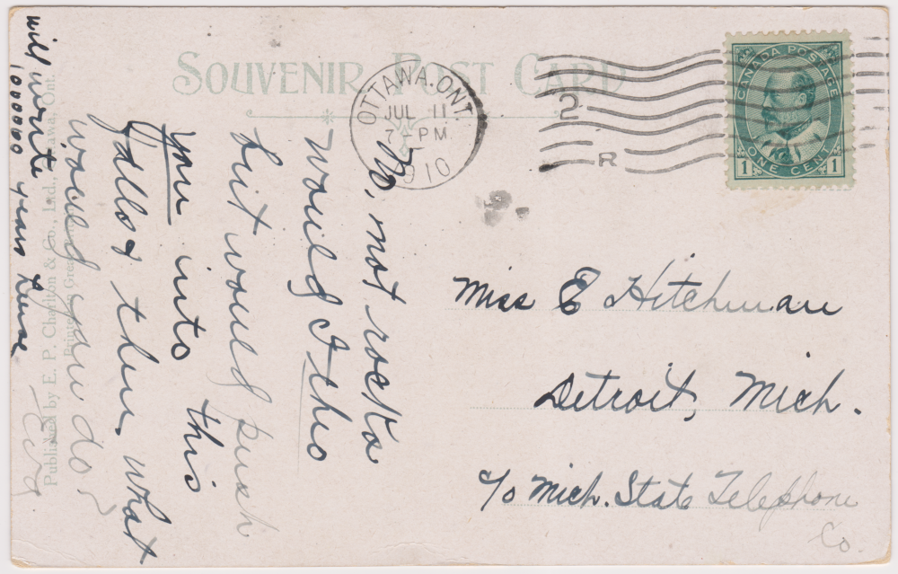
Frequently with this series, the message side of the first postcard precedes its picture side. This is done so I can provide a large image showing plenty of detail as I work to keep your image clear of the important column at the right.
Originally I was concerned that it was kind of plodding, boring and clunky to show you the message side of every card. However, it provides visitors to the site with as much technical and dating information about the card as I can provide.
... Sadly, I am no more an expert on postcards than I am an expert on Ottawa railways!

Below: Today it would be nice to be able to climb up the steps of the car's rear platform and go for trip.
* * *
Unfortunately, the train above is 'art' - probably drawn by a British artist who never saw Ottawa in person.
* * *
There are a lot of interesting features on the 1922 topographical map below. To provide as much detail as possible (and for your convenience) I split it into west and east sections. You should go and look at the whole, original map at its website (and many, many more!) if you are interested.
Below is the west section: showing the location of the CPR station - west of Ottawa's downtown ... and the railway bridge location, which crosses at Lemieux Island on the map.
 |
| from: Ottawa sheet, 1 inch:1 mile; 1922; Historical Topographic Map Digitization Project. https://ocul.on.ca/topomaps/ |
 |
| from: The Columbian Atlas of the World We Live In; Hunt and Eaton, 1892; http://alabamamaps.ua.edu/historicalmaps |
I was unable to resist this older 1892 map ... you can see the location of a few railway terminals.
They were drawn precisely at the left margin of the map.
Before the Royal Alexandra Interprovincial Bridge was built - you can see the presence of a steam ferry.
* * *
The next series of cards will be followed by the 'east sections' of these same maps.
* * *
Probably as well-known as the first postcard image at the CPR station, is this panoramic tour-de-force of art. It shows a wide variety of activities and modes of transportation. The detailed muddle of city seen over the roof of Union Station, suggests to me that this was originally a photograph ... with a great deal of added artistic embellishment. It is a nice panorama of the former concentrated 'centre of power'.
The original Centre Block is shown. A CPR passenger train is leaving to travel over the Interprovincial Bridge, with another arriving in the distance. If this image was older, we could imagine Sir John A Macdonald coming from his Kingston riding in a stateroom on that large steamboat. The roof of the new Chateau Laurier is portrayed as 'unweathered' copper.
All of these numbered (see the lower right corner) Valentine-brand cards are well-catalogued in internet databases if you ever want to research one.
* * *
Probably, many visitors will find this view to be the most interesting. It is in that particular period of 'within living memory' or 'just before my period of living memory' which people like to re-live or become nostalgic about.
* * *
The 'east section' of the 1922 map appears below. I chose the 1922 map because it showed our beloved Canadian Northern Railway reaching Ottawa from Montreal via the Mount Royal Tunnel and Hawkesbury.
For people not familiar with Ottawa: that fan of tracks above the letter 'W' of Ottawa's red downtown is where you'd find the Grand Trunk Central, later 'Union', Station.
 |
| from: Ottawa sheet, 1 inch:1 mile; 1922; Historical Topographic Map Digitization Project. https://ocul.on.ca/topomaps/ |
The St. Lawrence and Ottawa Railway appears again on this east section of the 1892 map below. It was leased to the CPR for 999 years in 1884.
Parliament and the steam ferry can be seen again in the lower left corner.
 |
| from: The Columbian Atlas of the World We Live In; Hunt and Eaton, 1892; http://alabamamaps.ua.edu/historicalmaps |
* * *
The Wild Card ...
The 'Hustler' bomber was as challenging to fly as it is cool to look at. The fact that the postcard elaborates that supersonic is 'faster-than-sound' reminds us that this aircraft first flew less than a decade after the first breaking of the sound barrier. This photo would probably be from the 1956 to 1960 period. Only 116 were built and the bomber was only in service 1960-1970.
The 1964 dramatic movie Failsafe is contemporaneous with the satirical movie Dr Strangelove. Failsafe showed stock footage of Hustler bombers at and beyond their 'failsafe points'.
The US Air Force did not support the premise behind either movie and gave neither the support which is so evident in the Jimmy Stewart 1955 'recruiting' film Strategic Air Command. Today the taxiing and takeoff footage from the movie Strategic Air Command is on YouTube because it provides close-up high-quality Technicolor prototypical footage of the B-36 Peacemaker bomber in operation.
In contrast ... at one point during the production of Dr Strangelove, it was Stanley Kubrick (if my memory is correct) who was concerned about being 'arrested'. The cockpit details and interiors of the B-52 aircraft movie set seemed shockingly accurate to USAF people who saw them. Kubrick feared an official investigation into a suspected leak of classified documents to the production company. Kubrick wanted good documentation available to prove that only open source material had been used.
As I mentioned, the Hustler bombers in Failsafe are shown traversing an area of the arctic on their way toward the USSR. So a 'map' of the arctic from that era would fit nicely into my postcard+map 'concept' for this series.
The next images come from what I thought was a quintessential Canadian used book: Arctic Air Navigation. It deserved a good and appreciative home. There are no colour photos in it. It is mainly a boring, nerdy, math, geometry and geography book with no pictures of aircraft, people or facilities.
But what could be more Canadian than having ice and snow beneath you ... no practical, usable map ... and only the stars above!
Navigating through the night in the high north has been such a feature of so much of our history. In general terms, this was a common experience of ... the Inuit and First Nations, those trading for furs on the land draining into Hudson's Bay, poor (often) doomed foreigners searching for the Northwest Passage to Asia ... or modern-day RCAF aircrew on search-and-rescue, resupply, or bomber interceptor missions in the north.
To aid these RCAF aircrew, this book was developed 'to act as a guide and reference manual for navigators and pilots engaged in northern flying and to supplement, not replace, basic navigation textbooks' ... 'as the result of discussions and interchange of ideas among navigators of the RCAF, RAF and USAF'.
 |
| from: Arctic Air Navigation; Keith R Greenaway, Flight Lieutenant, RCAF; 1951; Arctic Research, Defence Research Board. |
 |
| from: Arctic Air Navigation; Keith R Greenaway, Flight Lieutenant, RCAF; 1951; Arctic Research, Defence Research Board. |
The basis for the satirical movie Dr Strangelove was a serious novel: Red Alert (US title) Two Hours to Doom (UK title). It was written by Peter George (1924-1966) and published in 1958. George was a former RAF flight lieutenant and navigator.
Through the internet miracle of ebooks, you can read George's description of a navigator's work as his aircraft traverses the arctic and enters the USSR. The cold dark hostile operating environment is described particularly well. Being quite interested in that era of history, I've enjoyed reading Red Alert a few times - it is a serious novel of the period and raises important issues.