Do you like maps? We've got maps from Siberia to Waskada!
The trains of the Canadian Northern (and its antecedent railway, Lake Manitoba Railway and Canal Co.) had been running into Portage la Prairie via trackage rights on the Manitoba and Northwestern from Gladstone. However, they still didn't own or lease any rails which would bring them into Portage.
... That will change with this installment of my effort to understand how the Portage rail-scape evolved.
But first ... dredging up ancient history ...
It was fun to find this photo of Thomas Rosser (below) before he started working for the CPR. As you'll recall, Van Horne eventually fired him for conspiring to profit from his access to privileged corporate information concerning where the railway was to locate and build its facilities. Rosser is not found in the Biographical Dictionary of Railway Officials of America (1901 edition) so he might have found another line of work, retired, etc.
 |
| from: Northern Pacific, Main Street of the Northwest; Charles R Wood; 1968; Superior Publishing. |
I'm foreshadowing with some Northern Pacific images ...
 |
| from: Northern Pacific, Main Street of the Northwest; Charles R Wood; 1968; Superior Publishing. |
I am equally tickled to find a photo of these flatboats. You can imagine how desperate they were to have some form of 'heavy transportation' if they were building and using these things.
I have read that these boats would float ... and, failing that ... grind their way down the river - sometimes getting dragged off the riverbed when they became stuck in shallow sections, or during periods of low water in the river. This is a means of transportation which works well in only one direction - with the current. And, of course, they could only be used when the temperature was reliably above freezing. There would be the possibility that shallow-draft steamboats could have assisted flotillas of flatboats (loaded or empty), but there probably weren't that many steamboats around.
Returning your 'empties'? I guess they would have 'lined' them up-river using draft animals on a tow path. Probably hardware and other high-value cargoes could have justified the expense and hassle of using these vessels. However, cheap, reliable, all-weather railways would be a lot better.
These images also show that there was a lot of free, cross-border movement of people, goods and commerce. Certainly, First Nations people in the Canadian west would not hesitate to travel on their traditional, but newly-buffalo-free, lands. Speaking of First Nations and their traditional lands ... the railways, Canadian settlers, American settlers (923,000 between 1897 and 1913), and settlers drawn from Europe by the railways' overseas immigration agents ... were crossing as many borders as they needed to, to get to the 'Last Best West' in Canada.
 |
| from: The Last Best West; Jean Bruce; 1976; Fitzhenry & Whiteside. |
 |
The Last Best West; Jean Bruce; 1976; Fitzhenry & Whiteside.
From a Canadian government immigration pamphlet. |
 |
The Last Best West; Jean Bruce; 1976; Fitzhenry & Whiteside.
From a Canadian government immigration pamphlet. |
In Part 4, I was suggesting that the definition of Galicians would be open to nuance.
There we go: Now everyone's a Ukrainian.
The map from Part 4 is repeated below, along with another from 1904.
Naturally, there are differences between national/imperial boundaries ... and distinct or mixed ethno-cultural areas.
 |
| from: The Modern Age; Richards & Cruickshank; 1955; Longmans Canada. |
 |
Handy Reference Atlas of the World; 1904; JG Bartholomew.
No, Vladimir, no one wants to know what you think ...
Everyone is a Ukrainian (see above).
No time for your bad, sloppy and conveniently-selective history - that's my department.
|
* * *
... Man! Some people! ...
Back to our friend Hanna ...
 |
| from: James J Hill, Empire Builder of the Northwest; Michael P Malone; 1996; University of Oklahoma Press. |
 |
| from: Biographical Directory of Railway Officials of America; T Addison Bushey; 1901; Railway Age. edg |
... so ends Hanna's story of the Canadian Northern Railway gaining control of the former American-built and owned Northern Pacific lines,
including the lines near and through Portage la Prairie.
* * *
Here is what they'll say about the Canadian Northern in Port Arthur circa 1912 - about 10 years in the future.
This book was written by a Briton who was on a CPR-supported trip across Canada via the CPR.
 |
| from: From Halifax to Vancouver; B Pullen-Burry; 1912; Mills & Boon Ltd, London. |
 |
| Valentine Co postcard. Mailed from Port Arthur in 1912. |
 |
| WG MacFarlane Postcard. Unused, undated. |
* * *
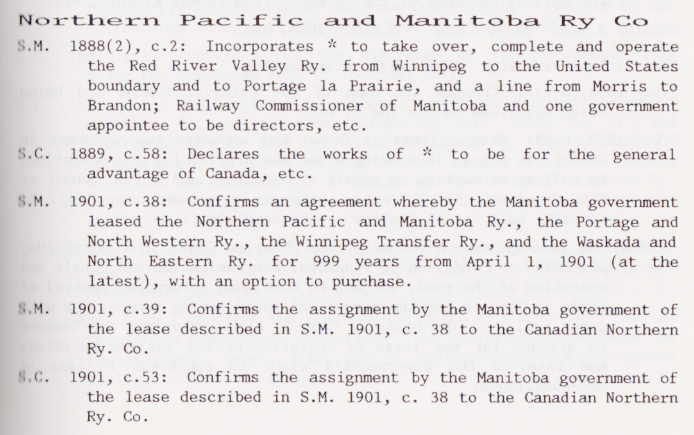
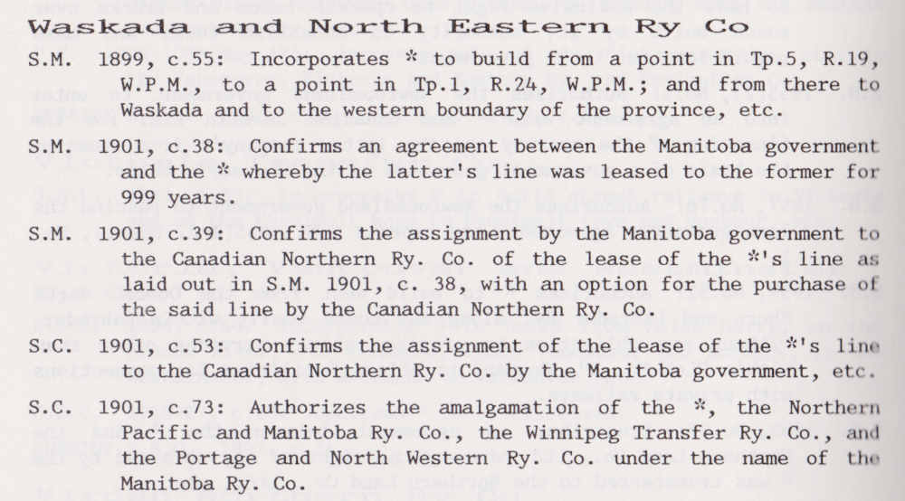
... but that's still in the future. And it will happen far from Portage. Below is the chain of legislation which shows how the Northern Pacific railway lines were finessed by the NP, CNoR and the Manitoba government into the rapidly-growing Canadian Northern portfolio of western Canadian lines. Oh, to have been a railway builder ... or a corporate lawyer ... back then!
 |
| from: A Statutory History of Railways in Canada 1836-1986; Dorman/Stoltz; 1987; Canadian Institute of Guided Ground Transport. |
* * *
Waskada or Bust!
 |
| From: Grant's Bankers and Brokers Railroad System Atlas, 1906; Toronto. Original maps: George F. Cram, Chicago. http://alabamamaps.ua.edu/ |
Above is the 'big picture' of what is happening in Manitoba vis-a-vis the Canadian Pacific (red, 15) and Canadian Northern (purple, 12) systems in 1906.
It doesn't really seem that any area of the Prairies is being neglected.
Does anyone see any Grand Trunk Pacific lines?
... Perhaps someone should tell Sir Wilfrid Laurier to hold off on the National Transcontinental and the Grand Trunk Pacific.
... Yes, I realize Laurier might want a nation-building 'Liberal transcontinental' matching the nation-building 'Conservative transcontinental' (CPR) ... but really!
The dystopian future: Bankrupt railways eventually get rolled into the CNR ... the CNR gets ... Turbotrain!
Please, no.
Even Vladimir thinks a functionally-complementary
Canadian Northern (western Canada) and Grand Trunk (eastern Canada) system
would have been better for Canada.
 |
| From: Grant's Bankers and Brokers Railroad System Atlas, 1906; Toronto. Original maps: George F. Cram, Chicago. http://alabamamaps.ua.edu/ |
Zooming in on developments in the Portage la Prairie area, above:
(Most dates were carelessly transcribed from: Lines of Country; Christopher Andreae; 1997; Boston Mills Press.)
- Gladstone to Dauphin 1897 (Lake Manitoba Rly & Canal)
- Portage to Winnipeg (NP 1889; Government of Manitoba to CNoR 1901)
- Portage to Delta (NP 1900; Government of Manitoba to CNoR 1901)
- Portage to Brandon Jct (CNoR 1905)
- Brandon Jct to Carberry Jct (CNoR 1905)
- Neepawa Jct to Carberry Jct (CNoR 1903)
Eliminating the need to use trackage rights on the Manitoba & Northwestern/CPR - Gladstone to Portage (with a bit of joint track at Gladstone):
- Gladstone to Neepawa Jct to Beaver (CNoR 1901)
- Beaver to Portage la Prairie (CNoR 1900)
 |
| from: Canadian Rail; October 1979. |
An undated photograph from Manitoba with no location noted.
This is a photo which is perhaps typical of the early years of the Canadian Northern Railway.
It provided a needed service without fanfare.
If the traffic warranted further development of the physical plant, it would come.
 |
| from: The History of Canadian Railroads; Greg McDonnell; 1985; New Burlington Books. |
A westbound drag of empties at Dauphin.
For those romantics who still 'believe in' the Canadian Northern Railway, this must be their favourite photo.


