Showing posts with label Halifax Time Ball. Show all posts

28 March 2026

International Meridian Conference, 1884 - Indefatigable Sandford Fleming


Halifax, 1949


With the help of his CPR employee pass, LC Gagnon was travelling over the Canadian Pacific system - beginning in Montreal, through Maine and New Brunswick, and by CPR ferry to Nova Scotia ... with  additional travel on the CNR line along Nova Scotia's south shore (as seen elsewhere on this blog).

At the Halifax Citadel, he has composed a photo showing two time appliances. 

The noon gun will provide an audible signal for citizens within earshot. The time ball is more interesting. 

I believe LC Gagnon photographed two time balls in Halifax during this trip. Overlooking the harbour with a good line of sight, the ball pictured seems to be an official device. There was another time ball farther down the hill as well. Watchmakers often prided themselves as being masters of time and they maintained their own standard clocks ... and time balls in some cases. Exact time was provided as part of their professional mission. Before 'Standard Time', US railroads would sometimes designate a particular local watchmaker's time for official use.

Generally, the time balls descended slowly for a minute or less as the hour approached, with the end of the descent marking noon (or perhaps 13hr - after daily noon re-verification). Time balls were essential to shipping. Their signal was not subject to delay - compared to the non-instantaneous speed of the gun's sound. Using a telescope, a distant ship could check its chronometer with precision by watching a time ball.

... I believe the Admiralty maintained a series of time balls along the British coast to support civilian and Royal Navy ships. 

*  *  *

During, and at the conclusion of, the decisive International Meridian Conference at Washington DC in 1884, Sandford Fleming's biographers of 1915 and 2000 do not think he was properly recognized for his work to promote and support the adoption of a new system of time reckoning for the world. 

Lawrence Burpee (Sandford Fleming, Empire Builder; 1915; Oxford Press archive.org) ended his Standard Time Movement chapter with the words of the Astronomer Royal of Russia, M Otto Struve: 

'It is through Mr Fleming's indefatigable personal labours and writings that influential individuals and Scientific Societies and Institutes in America and Europe have been won over to the cause.' 

Looking over all of the microfilmed documents of Sandford Fleming preserved by the Canadian government (available at archive.org), I discovered that the official account of the Washington Conference is missing - although the official account translated into French is available. 

... Fleming's biographer of 2000 states that the US State Department was unable to find a French translator in Washington DC to satisfy the request of the delegation from France - it was Fleming who did. 

Fortunately, Project Gutenberg has preserved and uploaded the official record in English and you can read the whole thing at this link:

International Conference Held at Washington for the Purpose of Fixing a Prime Meridian and a Universal Day. October, 1884.

*  *  *

A recap of Fleming's evolution of thought ...

If you've been following this series, you'll recall that Fleming was miffed because he was stuck at Bundoran, Ireland overnight because of a timetable misprint. His 5PM train was actually scheduled for 5AM the next morning.

In addition to advocating the use of a 24-hour clock, his first approach to the larger issue of world time reckoning was Utopian. He wanted to convert the 'hour numbers' (i.e. 1 to 12) on a clock to letters. This idea would require the engineering of a new clock device which took 24 hours for its hour hand to complete its trip around the watch face. The 24-hour cycle matched that of the earth. Essentially, the new timepiece was a schematic representation of world time zones, designated by their own letters.

Below, the whole world is shown at 'A' o'clock because the sun is over the 'A time zone' in eastern Russia. For those Russians, 'A hour' is always noon. For those in the N time zone in western Africa 'A' o'clock is always midnight. 

This seems odd, because we know how all this turned out ... but consider the global circumstances in the mid-1800s ...

... At that stage of history, a few smaller countries used nation-wide standard times because of railway or military imperatives. 

For example, in the UK, the railways all agreed to use Greenwich time - from the Royal Observatory - as the basis for all their schedules. After this change, people with the money to travel by rail set their watches to 'railway time'. The rest of society - if they had the money to buy their own personal watches or clocks - gradually followed suit.

... However, most places in the world using clocks set them by the sun at noon. There were no time zones - just local 'natural' time.


After the Washington International Meridian Conference of 1884 was over, Fleming put together a 110-page compendium of all of his time ideas, the responses to them, and their refinement ... for posterity. It is linked below if you want to see what he wanted us to remember about his persistent efforts. (It is the source of these 5 excerpts.)

archive.org link:

In the late 1870s ... Fleming 'worked through channels' in Canada, employing the Governor General (Queen Victoria's son-in-law) to help get the world thinking about time reckoning ... i.e. 'standard time and time zones'. 


As we've seen, experts like the UK Astronomer Royal - George Biddell Airy (at Greenwich) - were sometimes brusque when returning requested feedback. When appropriate, Fleming would modify his ideas. He'd continue to be patient and persistent in promoting them. 

Supportive colleagues like American meteorologist Cleveland Abbe, who was necessarily interested in the science of measuring (Metrology), were natural allies of Fleming. As he built his network, Fleming presented his papers in the US and in Europe.
 
The advent of the world-wide telegraph system (before the invention of wireless) enabled information and time signals to be sent anywhere at the speed of light.

Having a universal standard time system and clearly-defined time zones would enable meteorologists like Cleveland Abbe to know exactly when a tornado had struck a particular settlement. Appropriate records could be made and warnings could be sent out by telegraph to other places which might soon be affected.


October 1884, the International Meridian Conference

The Americans take the bull by the horns ...

The first order of business was to elect a Chairman of the Conference ...

The delegates elected the chairman of the delegation of the United States of America, Admiral C. R. P. Rodgers. Almost all of his first brief address is reproduced here, taken from the Project Gutenberg document, linked above. It was concise and to the point.

'Gentlemen: I beg you to receive my thanks for the high honor you have conferred upon me in calling me, as the chairman of the delegation from the United States, to preside at this Congress. To it have come from widely-separated portions of the globe, delegates renowned in diplomacy and science, seeking to create a new accord among the nations by agreeing upon a meridian proper to be employed as a common zero of longitude and standard of time reckoning throughout the world. Happy shall we be, if, throwing aside national preferences and inclinations, we seek only the common good of mankind, and gain for science and for commerce a prime meridian acceptable to all countries, and secured with the least possible inconvenience.

'Having this object at heart, the Government of the United States has invited all nations with which it has diplomatic relations to send delegates to a Congress to assemble at Washington to-day, to discuss the question I have indicated. The invitation has been graciously received, and we are here this morning to enter upon the agreeable duty assigned to us by our respective governments.

'Broad as is the area of the United States, covering a hundred degrees of longitude, extending from 66° 52' west from Greenwich to 166° 13' at our extreme limit in Alaska, not including the Aleutian Islands; traversed, as it is, by railway and telegraph lines, and dotted with observatories; long as is its sea coast, of more than twelve thousand miles; vast as must be its foreign and domestic commerce, its delegation to this Congress has no desire to urge that a prime meridian shall be found within its confines.

'In my own profession, that of a seaman, the embarrassment arising from the many prime meridians now in use is very conspicuous, and in the valuable interchange of longitudes by passing ships at sea, often difficult and hurried, sometimes only possible by figures written on a black-board, much confusion arises, and at times grave danger. In the use of charts, too, this trouble is also annoying, and to us who live upon the sea a common prime meridian will be a great advantage.'

As you'll see on Fleming's summary of the Conference, below, the delegations took over a month to conduct their 8 sitting days. There were breaks to allow for questions to be discussed with delegates' home governments and for data to be gathered and prepared for presentation. 

One key consideration was the use of the Greenwich Observatory/Meridian as longitude 'zero' and time 'zero' for the civil day of the world. As mentioned, Greenwich charts were widely used. Other nations had similar observatories providing the basis for their own charts. To choose Greenwich meant that these other observatories would not retain their national importance and tradition.

As a secret supporter of the Greenwich Meridian, Fleming wanted to avoid provoking other nations' anger by implying that their meridians were inferior in some way. To avoid this, right from the beginning of his work, he suggested his Proposed Common Prime Meridian in the middle of the Pacific Ocean ... as seen in the world diagram at the top of this post. 

At one point when the French delegates felt the relevance of the Paris Meridian was being lost, a vote was called on Fleming's anti-Prime Meridian and it was soundly defeated. So much for trying to be considerate ...

However, Fleming made the presentation below to show that the Greenwich Meridian did have the greatest use - as measured by tonnage and the absolute number of ships using the Greenwich charts. 

... Nonetheless, he points out, below, that his 'anti-Greenwich' meridian would avoid choosing the meridian of any particular nation. This is because the telegraph wires can provide the instantaneous propagation of an official time signal (from any observatory location to be chosen) to the entire world. 


The key holdouts in accepting the Greenwich Meridian - the French delegation - would abstain from voting in the end. Two people attended for France ... the world's leading spectroscopist ...  i.e. someone who breaks down the spectrum of a star's light to determine the elements of its composition ... and the French Ambassador to the United States. Astronomers are generally not called upon to fight in debates involving international diplomacy. 

Below is Sandford Fleming's concise report of what exactly was achieved at the International Meridian Conference at Washington DC in October 1884.


Any Canadian delegate, in the international sphere, would be regarded as coming from the British Empire at this point in history. In spite of all of his spadework to make a world time reckoning system reality, Fleming was forced to tag along with Britain. However, he was neither a military person, nor an academic, nor the member of a government, nor a diplomat. The British delegates tolerated his presence as kind of an oddity. There was no doubt that they would be campaigning to ensure the Greenwich Meridian was used.

The well-prepared naval astronomers generally had instructions from their governments to ensure the Greenwich Meridian was chosen as the Prime Meridian with the civil day beginning at midnight at that location. 

In the United States, William Frederick Allen (1846-1915), a civil engineer by training and the secretary of the General Time Convention of the American Railroad Association is generally cited as the inventor of standard time and [American] time zones. He had presented his system on 8 April 1883 at the ARA semi-annual meeting in St Louis. (As we've discussed, Fleming was pushing his papers back in the 1870s.)

Here is WF Allen on the cover of the December 1887 edition of the Official Guide. This old, brittle document prefers to be photographed. 


Allen attended the Washington Conference and the main thrust of his presentation was to affirm that the US railroad system was based on the Greenwich Meridian. The railroads had adopted his time zones in 1883. (Canadian railways had adopted the continental railroad standard at exactly the same time as the US railroads.) The railway time zones were optimized for railway operations. 

... If international time zones - separated by exactly 15 degrees - were overlaid on the railroad time zones, there was great potential for confusion. Official 'local time' should not be different from 'railroad time'.

If you haven't seen the ARA's original railroad time zone scheme, it is in a previous post, linked below.


In the end, the international time zone system was implemented loosely, with local patterns of human activity considered. Over time, Allen's system was modified to better meet the needs of citizens. Everybody survived the experience.

*  *  *

What did Fleming get?

Fleming's Utopian 'lettered hour of the day' 24-hour-circle watch scheme fell by the wayside early in his work on this project. 

Today, UTC does provide a form of his Cosmopolitan or Cosmic Time for scientific, military, and general international use. 

However, if you turn on your TV or computer, you'll notice that much of humankind never did get around to learning how to tell the time using a 24-hour clock ... and no longer using AM or PM. This was seemingly the original frustrating issue which got Fleming thinking about time in the first place!

*  *  *

Where they 'make'  the Greenwich Meridian ...


Here is the specific wording from Resolution 2 of the International Meridian Conference, 1884.

" the meridian passing through the centre of the transit instrument at the Observatory of Greenwich "

Here are two images which enable you to see this exact location, back around the time of Sandford Fleming and the Washington Conference.


from: Greenwich Observatory (article); 1872; Popular Science Review. archive.org

The image above shows and describes part of the process used around the time that Fleming began his work with standard time.

*  *  *

After Sandford Fleming was knighted by Queen Victoria in 1897, here is the building housing the transit.
The camera is sitting right on the Prime Meridian. 

The Royal Observatory Greenwich; E Walter Maunder; 1900; Religious Tract Society. archive.org

*  *  *

The system is available for use ...

The series of time zones, with Greenwich as the Prime Meridian, is presented in this British atlas from 1904. 

from: Handy Reference Atlas of the World; JG Bartholomew; 1904; John Walker & Co.

end

13 January 2017

CNR 1949 Halifax


This post features snapshots taken by my father during a vacation taken mainly on the rails of his employer in October 1949.

To recap his trip up to this point ... from Montreal he had taken the CPR short line through Maine to Saint John; the CPR ferry to Digby, Nova Scotia; and he had arrived in Halifax on a Dominion Atlantic Railway (CPR) train through the latter's running rights over the CNR.


Above, is my father's Halifax hotel - the CPR Lord Nelson. The lens on his box camera tends to fish-eye and blur the corners of some of his photos. This photo nods to a major change in the urban transit system of Halifax.

The last run of Halifax's streetcar system had taken place five months before these photos - back in May 1949. The catenary above is being used by electric trolley buses. 

A quick orientation to Halifax follows ...

From: Canada, A Regional Analysis; Putnam and Putnam; 1970; JM Dent.

This view of Halifax comes from the 1960s. Downtown Halifax is at the centre, bottom. Dartmouth is across the harbour. To the right is the Atlantic Ocean, to the left is Bedford Basin - an excellent sheltered area in which trans-Atlantic wartime convoys were assembled. 

'The Narrows' was the location of the Halifax Explosion of December 6, 1917. Three piers at the right extremity of Halifax mark the location of the CNR yard - completed after the Great War; the passenger station; and today's modern container port.

The Angus L Macdonald Bridge connects Halifax and Dartmouth at the Narrows - it was built between 1952 and 1955. It is a suspension bridge, designed to clear the superstructures of merchant and military ships using the inner harbour. 

While cross-harbour ferry transportation was particularly busy with people commuting back and forth during the years of World War Two ... there was no cross-harbour ferry for railcars between the two cities.

Here is a historical curiosity ... there had been a double-tracked railway bridge across the harbour ...

The Halifax and Eastern Railway Company twice built a railway bridge across at the Narrows. In 1884, construction started to build the bridge to connect the Woodside sugar refinery near Dartmouth to the Intercolonial Railway's Richmond Yards. This was a low wooden trestle bridge with a steel swing-span mounted on stone abutments. The first train travelled across the double-track structure in 1885 and the bridge was destroyed in a storm in 1891 ...

Caution suggested the idea of building track to Dartmouth by land from the head of Bedford Basin. However, they ignored caution and immediately rebuilt the bridge. It floated away for good in 1891, leaving 23 cars stranded at Dartmouth. 

Since then, Windsor Junction has linked the land-based railway lines of Dartmouth and Halifax. 

As you can imagine, there was a very high level of shipping activity through The Narrows, particularly for the purposes of assembling wartime convoys. It seems likely that having the obstruction of a railway swing bridge across this busy area would not have been tolerated for long, had the bridge survived.

*  *  *


Quite naturally, most of us are immediately drawn to the 'old cars' shown in historical photos. Besides being sources of nostalgia for many ... the short lifespans of both the in-fashion sheet metal designs, and of the vehicles themselves, are quite helpful in dating photos precisely.

The Isaac-Newton-style water system 'pressure intensifier' on the roof ... and an extinct brand of Canadian department stores provide less precise dating for this October 1949 photo.


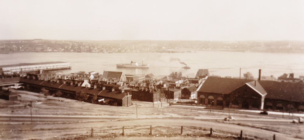
My father's first harbour photo is taken from the Halifax Citadel hill and looks up the harbour toward Bedford Basin.


A freighter may be under tow. In the foreground, the row-housing here might post-date the Explosion. Wood-framed dwellings on the land rising up from the harbour were generally swept away or heavily damaged by the 1917 Explosion in the Narrows. This photo has sepia-ed itself.


An enduring sight today is the Halifax Town Clock. It was put in service in 1803 - ostensibly to keep the local military forces punctual. Today Parks Canada is responsible for Citadel Hill historic sites, including the clock.


Above, are two systems used to communicate time - guess which of the two is more prized for its precision ...

The British military tradition of the Noon Gun would be accurate enough for normal business and social interactions. 

According to a write-up by Dr Randall C Brooks of the Canada Science and Technology Museum, the time ball shown above was completed in 1904 and was probably removed circa 1959. 

At five minutes to noon, the ball was raised halfway. At one minute to noon it was raised to its highest point of travel. The ball was dropped by electricity at noon exactly - the electrical current coming from the nearby observatory, where the sun's transit was used to determine the exact time.

During the early 1900s, the Time Ball would provide the more accurate signal for anyone with serious precision needs - ocean navigation using accurate ship chronometers, for example. The visual cuing of the raised ball, and the 'speed of light' nature of the ball dropping sight had advantages over the less precise - but more fun - Noon Gun.

If you are curious about the spotting differences between the two cupola balls above ... you'll notice that the official time ball is constructed to rise and fall within a metal framework. In contrast, the ball on the Halifax Town Clock is not. As well, the two cupolas are different in their construction.

*  *  *


The Nova Scotia Legislature is having some stonework done.
... Somewhere, there must be parking meter fans and 'rivet counters'.


The Scotian was in use from 1946 until 1955.


This is the view from the ferry to the Halifax side of the harbour.
You can see the way Citadel Hill dominates the harbour here.


The Dartmouth shore is seen above, also from the Scotian. If you check the 1957 CNR Dartmouth Subdivision footnotes (far below), you'll see that there are precautions for movements over the rail crossing at the ferry ... on the same track as that hopper at the right.


In the post-war mania for rubber-tired vehicles, these Fort William-manufactured trolley buses had significant advantages over the streetcars they were replacing ... The trackwork no longer had to be maintained; the rubber-tired road adhesion of torque from electric motors provided unprecedented acceleration; unlike streetcars, trolley buses could swerve to the curb to pick up riders; the buses were very quiet and smooth riding.

Of course, the children of this transit revolution were themselves dispatched by the march of technology. With powerful postwar diesel engines in buses, the trolley bus catenary would no longer need maintenance. While noisier, diesel buses could operate on any road - not being limited to routes with overhead wiring.


The trolley bus above is just leaving its own 'Belt Line' bus stop.

from: Canada Handbook 1946; Dominion Bureau of Statistics.
While looking around for other illustrations to include, I found this image from the government's Canada Handbook of 1946. The hand-drawn marks refer to the Bedford Magazine explosions of July 18, 19 1945. This occurred after Germany had been defeated but before the end of the war in the Pacific. 

As you can imagine, military ships participating in ocean convoys needed all kinds of exploding materials - from anti-aircraft machine gun ammunition, to anti-ship torpedoes, to anti-submarine depth charges. These dangerous articles had been located away from the main areas of civilian population ... The Halifax Explosion of 1917 had provided the 'never again' incentive to ensure the safe handling of explosives around the harbour. While many windows were broken in the city, there was no civilian loss of life from the Bedford Basin explosions.

You can easily pick out Citadel Hill. In the foreground, you can see the CNR Hotel Nova Scotian as well as the new Halifax station, CNR yard, and the piers for the ship/rail transfer of military personnel and people reaching or departing Canada by ship.

*  *  *

The local CNR employee timetable pages for the Halifax and Dartmouth areas are provided below.

The following timetable images are from
CNR Atlantic Region, Maritime District,
Timetable 94, October 27, 1957.