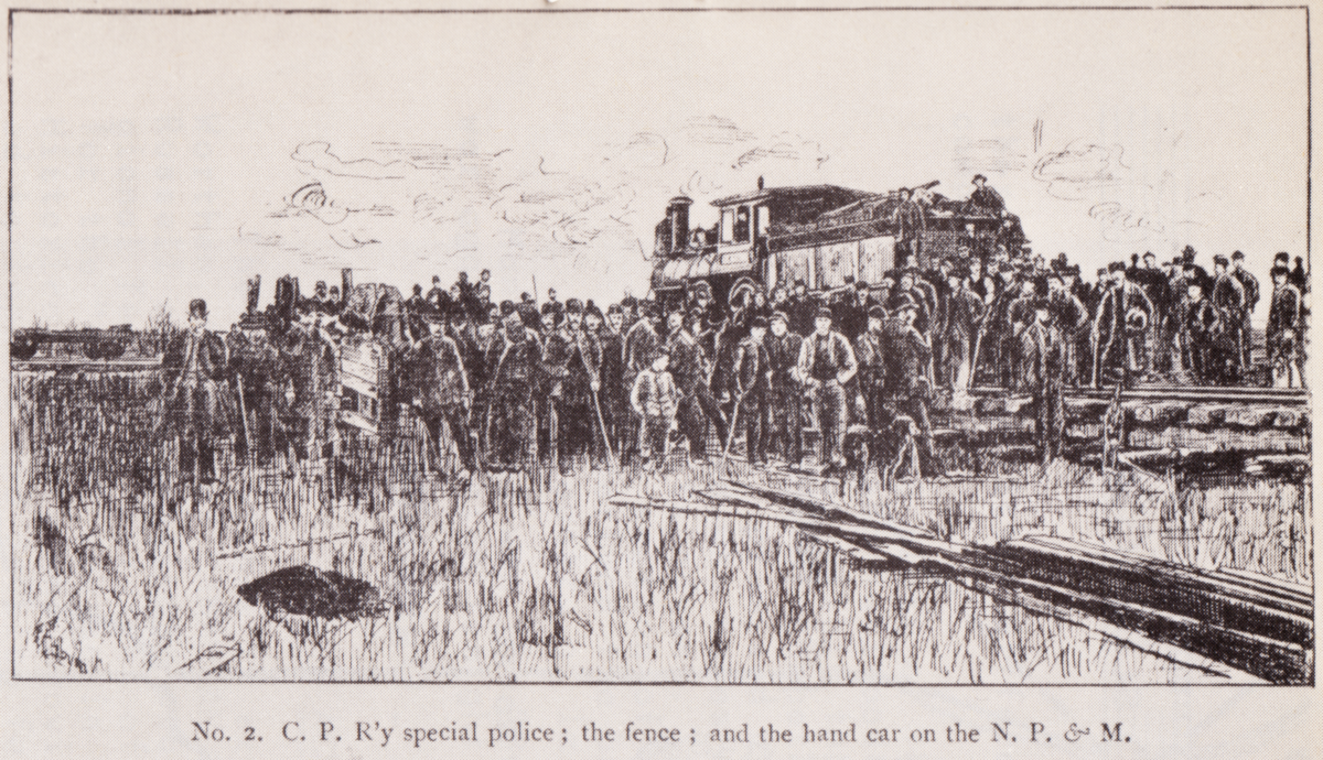
Ditching locomotives and using a live steam hose from a locomotive to threaten opponents.
In Canada's wild west, the CPR was not going to make it easy for opponents to undermine its Manitoba business plan.
But would a duopoly which depended on a small network of foreign branch lines provide the rate relief which Manitoba farmers were after?
First, here is Hanna's account of events ...


The crossing at Headingly (below) comes up more than once in secondary historical sources of these events. This may have been an early flashpoint in the effort to create a competitor for the CPR. It is possible that some secondary writers were unaware of the local geography, but this should not have been the case for Hanna.

Oh. Well ... Emerson is on the east side of the Red River.
The CPR line crossing at Headingly goes west to Souris.
Perhaps Hanna didn't know/remember the local geography as well as one would expect!

* * *
Who was William Whyte?
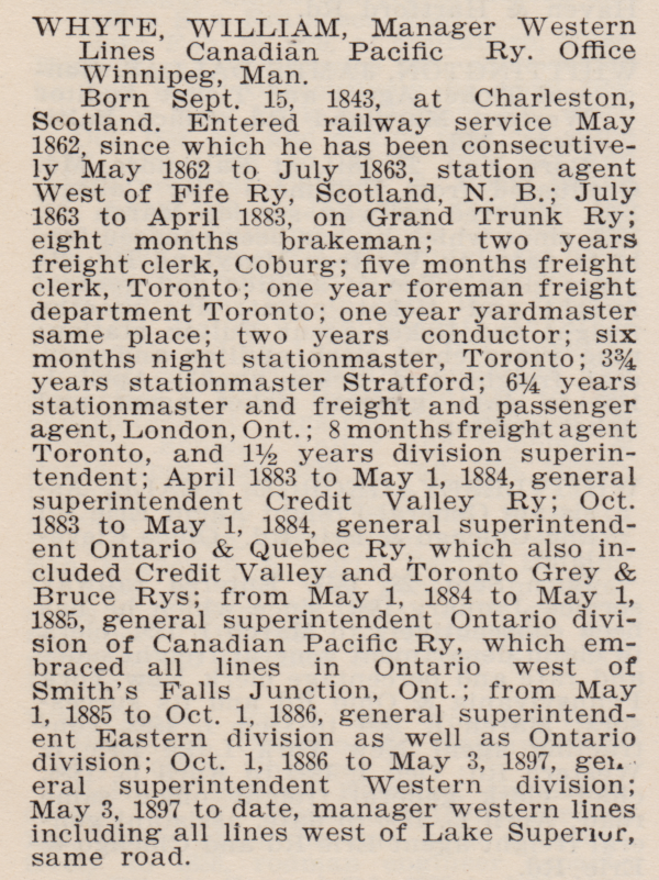 |
| from: Biographical Directory of Railway Officials of America; T Addison Busby; 1901; Railway Age. EDG |
* * *
The CPR monopoly and events leading to the Battle of Fort Whyte according to Van Horne from:

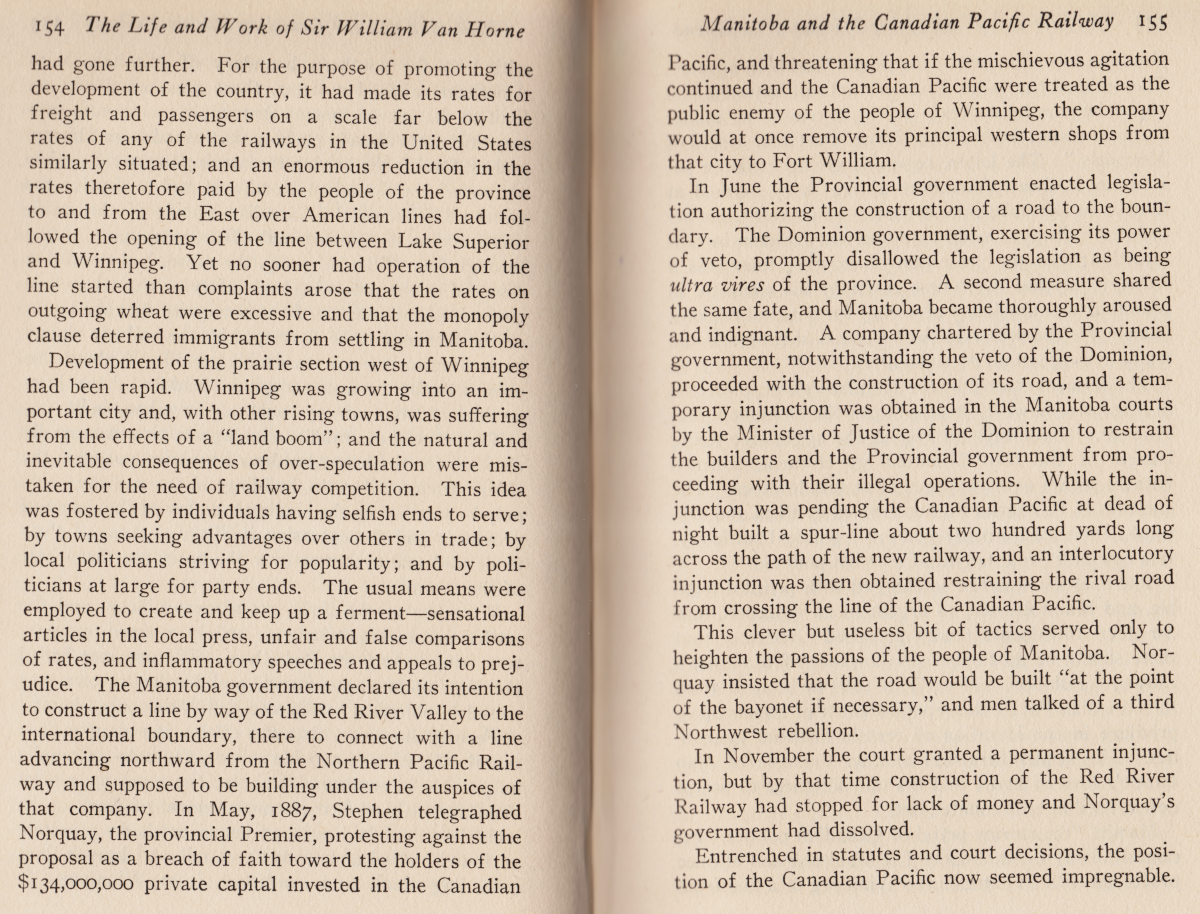

The Branch to Pembina (top, P 157) is consistent with an account below.
We'd expect the CPR to have a corporate memory of where the incident took place.

* * *
A more contemporary account by a local author from 1890,
with some local Portage la Prairie history as a bonus.
 |
| archive.org |


The Manitoba South Western Colonization Railway Co (CPR)
amalgamated with the Souris and Rocky Mountain Railway Co in 1880.
It went through Headingly (1885).
The Pembina Mountain Branch (CPR) went south from St James,
and west from Rosenfeld (1882) through Winkler and Pilot Mound.


 |
| from: archive.org |
Here is a beautiful map:
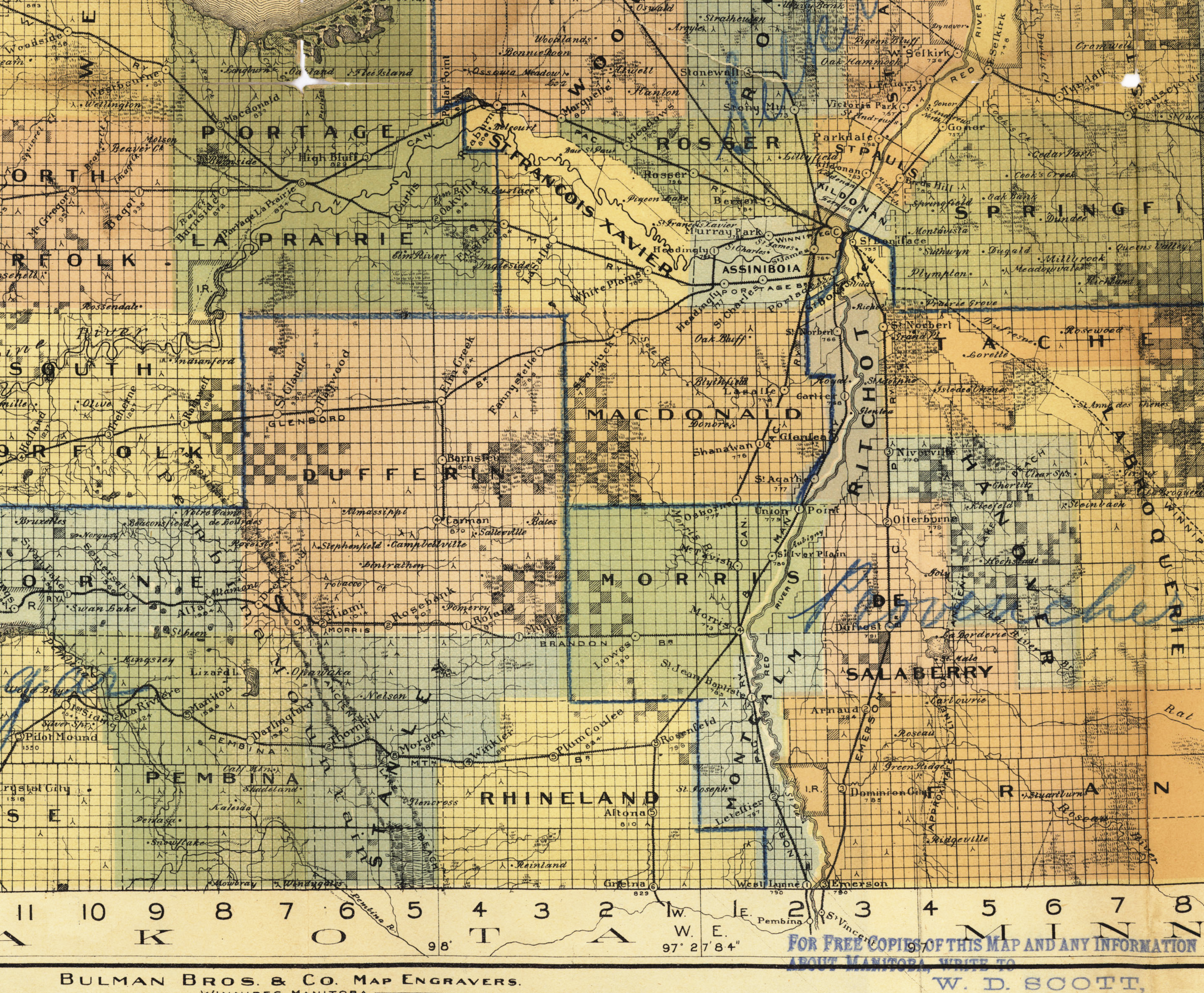 |
| Bulman Bros Map of Manitoba by Authority of the Provincial Government Winnipeg, April, 1897. From: https://www.flickr.com/people/manitobamaps/ |
* * *
Headingly or Fort Whyte?
 |
| from: Manitoba's Railways, George A Moore; Canadian Rail July 1975; Canadian Railroad Historical Assn. |

If you follow the CPR branch all the way south and west from St James,
you'll see by its label (on the large map) that it was the Pembina branch
which was being crossed in the Canadian Rail article paragraphs above.
(One thing which confused me was the mention in the Canadian Rail article of the
'Southwestern & Pembina Mountain Branch'. I think they were two separate branches
and - heading west from NP&M's Portage Jct - the Pembina Mountain Branch would be crossed first.)
Portage Junction (NP&M) is shown to the right of the white star.
If the 'offending' line was being built westward from Winnipeg,
the first confrontation of the NP&M with the CPR would occur at the white star.
A modern map from the Canadian Rail follows below.
* * *
Here are some images and more elaboration on the confrontation.
 |
| from: Newsletter from 2001. https://www.fortwhyte.org/ |
 |
| from: Manitoba's Railways, George A Moore; Canadian Rail July 1975; Canadian Railroad Historical Assn. |
 |
| from: Manitoba's Railways, George A Moore; Canadian Rail July 1975; Canadian Railroad Historical Assn. |
 |
| from: Manitoba's Railways, George A Moore; Canadian Rail July 1975; Canadian Railroad Historical Assn. |
 |
| from: Manitoba's Railways, George A Moore; Canadian Rail July 1975; Canadian Railroad Historical Assn. |
* * *
The Various Locations of the 'Fort Whyte' ...
 |
| from: Manitoba's Railways, George A Moore; Canadian Rail July 1975; Canadian Railroad Historical Assn. |
 |
| from: Altitudes in the Dominion of Canada; James White FRGS; 1901; Geological Survey of Canada. |
And here is the South Western Branch through Headingly with no Fort Whyte.
 |
| from: Altitudes in the Dominion of Canada; James White FRGS; 1901; Geological Survey of Canada. |
 |
| from: Place-Names of Manitoba; 1933; Geographic Board of Canada. archive.org |
 |
| CPR employee timetable. |
* * *
Railway legislation related to this story:
 |
| from: A Statutory History of Railways in Canada 1836-1986; Dorman/Stoltz; 1987; Canadian Institute of Guided Ground Transport. |
* * *
Was a Satisfactory Outcome Achieved?
 |
| from: The Brandon Weekly Mail, October 1889. archive.org |
* * *
The Northern Pacific Lines in 1901
 |
| from: Altitudes in the Dominion of Canada; James White FRGS; 1901; Geological Survey of Canada. |
 |
| from: Altitudes in the Dominion of Canada; James White FRGS; 1901; Geological Survey of Canada. |
 |
| From: The Colonist; May 1897; JA Carman. archive.org |
* * *
So, after the CPR, the Northern Pacific became the second railway to give Portage la Prairie an eastern rail outlet.
We can probably trust the CPR corporate memory that the location of Fort Whyte was south of St James and not at Headingly.
It seems possible that something happened at Headingly and that some of the non-CPR versions of events are trying to refer to it.
...