Showing posts with label World War One. Show all posts

10 November 2023

Ypres (Ieper) Postcards and Maps from the Great War

There is a reason why a painting of the ruins in Ypres (among others) was commissioned for a Canadian museum of the Great War ... or World War. The museum was never built and that painting (among those others) has been displayed in the Senate of Canada.

The Reason: Ypres (today known as Ieper) was one well-remembered location which most Canadian soldiers passed by ... on their way to, or from, battle ... at some point in the war.

The map below shows the area of Flanders where Canadian forces often fought. 

As a generalization, the French took care of business to the south of the Somme River. Other British Empire and 'dominion' forces were often north of the Somme. The Anzacs and Newfoundlanders could sometimes be found in Egypt or in the Dardanelles. And so on - it really was a world war, as many of the various empires' colonies were drawn into the conflict.

  • That particular corner of Belgium where Ypres is located was the only corner of Belgium which was left unoccupied by the German Empire - so plucky little neutral Belgium, and its popular king, lived on and was free.
  • That corner had a secondary symbolic value. The antiquated treaty intended to protect Britain from French invasion ... yes, really ... was Britain's reason for getting involved in the European War: 'Belgium must remain neutral'. 
  • And that same proximity to the Channel and England meant that places like Dunkirk and Calais had to be protected from German capture. The British Empire armies on the continent needed to import all the food and materials necessary to carry on the war.

from: from: Canada at War; Leslie F Hannon; 1968; McClelland & Stewart.

The Second Battle of Ypres involved German forces releasing poison gas (chlorine) as a weapon of war for the first time on the Western Front. They had already experimented with gas shells on the Eastern Front. Canada was key in preventing the line from collapsing as the Germans followed their gas and attacked. The date: 22 April to 25 May 1915.

The Third Battle of Ypres, or Passchendaele ... (today Passendale) ... was a pointless exercise and involved fighting through an endless bottomless sea of infectious mud while under fire from the Germans - shooting down from the high ground. Other Empire forces failed to capture the heights. The Canadians succeeded. The date: 31 July to 10 November 1917.

Generally, British troops often anglicized hard-to-pronounce foreign place names, so to many Ypres was 'Wipers'.

*  *  *

from: Borden, His Life and World; W Kaye Lamb; 1977; McGraw-Hill Ryerson.

Book caption: 'Eager recruits forcing their way into the recruiting centre in Ottawa in the first days of the First World War. No one had any conception of what lay ahead; the chief anxiety of many was fear that the war would be over before they had a chance to participate in it.'

 The term of enlistment was 3 years or for the duration of the war.

*  *  *

from: The World War, Vol I; ed. Holland Thompson; 1921; Grolier.

The contemporary map, above, shows that continuous line of trenches - running from Switzerland to the sea.

*  *  *

from: The World War, Vol I; ed. Holland Thompson; 1921; Grolier.

On the map above, you can see other reasons why the Germans had an interest in Ypres. 
It was a transportation centre with railways, canals and roads passing through it.

*  *  *

from: A Pictorial Memoire of World War One by James Scott Parke; Laura Anne Lee; 2001; self-published.

The Cloth Hall was built between 600 and 700 years before the Great War. It was used for ... cloth. Ypres was an important centre of the textile trade and the great hall was used as a market and warehouse.

Our maternal grandfather was there ... as noted above on one of the photographs he collected. You can search for the previous piece on the Canadian Overseas Railway Construction Corps to find out a little about him if you wish.

*  *  *

For Canadian soldiers, this type of postcard recorded the terrible destruction they had seen, and what had existed before the war.


A Lieutenant Ernest James Scott died on 3 May 1917. 
He is buried at Ecoivres Military Cemetery, Pas de Calais, France

*  *  *


Before drones and satellites, the first primitive airplanes and balloons were used for reconnaissance.
Planners needed to know where enemy troops were and where their artillery was located.

Any significant surviving tall building was used for reconnaissance.
Church steeples and Cloth Halls were used for this purpose.

*  *  *


The crest in the lower left corner is a French postcard artist trades symbol.

*  *  *


*  *  *


*  *  *

from: The Western Front, 1914-1916; Michael S Neiberg; 2008; Amber Books.

Above: A view of part of Ypres after artillery bombardment.


*  *  *


Passchendaele - Third Battle of Ypres

Churchill referred to this battle as 'a forlorn expenditure of valour and life without equal in futility'.


from: The World War, Vol II; ed. Holland Thompson; 1920; Grolier.

You can see the front line approaching Passchendaele at the right side of the map.

*  *  *

from: The World War, Vol II; ed. Holland Thompson; 1920; Grolier.

A closer look, above. You can see the main tactical ridge at the right.
The Germans would have had machine guns in pillboxes and artillery on other surrounding high ground.
Notice 'Anzac' and 'Black Watch Corner' labels to the south-west of the ridge.
I believe the unnamed hills are often identified by the first digits of their stated height on military (topographic) maps.

If you follow the meandering lowland drainage patterns on the map above, 
you can bet that they have become completely disrupted by artillery.
Buildings and roads depicted on the map would also be unrecognizable at ground level.

*  *  *

The last three images were taken during or after Third Ypres.

from: The First World War; Hew Strachan; 2003; Simon & Schuster.

Falling off a duckboard and silently drowning in mud was a significant hazard - particularly at night.
You can't dig trenches here, so built-up sandbagged breastworks would be necessary for defence.


from: The Western Front, 1917-1918; Andrew Wiest; 2008; Amber Books.

Barbed wire entanglements targeted by German machine guns would impede the British forces as they approached pillboxes and artillery positions. 

from: Canada at War; Leslie F Hannon; 1968; McClelland & Stewart.
While those two 'laddered' trees still had branches and leaves, they were used for reconnaissance.
You can see how hopeless it would be to try to attack the enemy occupying the height of land in this environment.


'Mud: We slept in it, ate in it. It stretched for miles, a sea of stinking mud. The dead buried themselves in it. The wounded died in it. Men slithered around the lips of huge shell craters filled with mud and water. My first trip to this awful place was at night. For it was at night that men crept out of their holes at Passchendaele like rats. On each side of the duckboard track lie the debris of war. Dead mules. Their intestines spewed out like long coils of piping. Here an arm and a leg. It was a nightmare journey. Finally dawn broke, a hopeless dawn. Shell-holes and mud. Round-about rifles with fixed bayonets stuck in the mud marking the places where men had died and been sucked down.'

Private A.V. Conn. The Western Front, 1917-1918

05 November 2023

1915 - The Roll of the Canadian Overseas Railway Construction Corps & An Artifact Finally Reproduced

Many years ago, my father (LC Gagnon) received a couple of artifacts from my maternal grandmother because he was 'interested in trains' and, of course, he had been employed by the Canadian Pacific Railway.

First, here is the nominal roll of personnel in the Canadian Overseas Railway Construction Corps. 

If you are not acquainted with the work they did, here are a couple of photos as a quick introduction.

from: The Railway Contractors; Geoffrey W Taylor; 1988; Moriss Publishing. 


The Canadian railway boom exhausted itself as the Great War began. Few countries had as many workers with so much knowledge and experience building railways through irregular muskeg 'wasteland' as Canada.

By 1914, the 'old style' warfare of parade-square engagements on European battlefields was dead. The glamour of the cavalry performing reconnaissance ... or chasing down routed infantry with sabres drawn, was gone. Instead, for the immediate future, draft horses and mules would be needed to pull artillery and other loads where roads or tramways could be maintained ... and to prepare the way for the iron horse. 

For battlefield killing using vast quantities of artillery shells and other mass-produced armaments, the combatants would need industrialized transportation.

Canadians, and slightly-Canadianized immigrants from the British Isles (see the roll below), would be filling the demand for more and more railways. All these railways eventually reached a human-made wasteland - which was produced at great cost and known as The Front.


From past experience, I believe you can find this and other similar documents at archive.org

The Canadian Government's microfilm records are digitized and searchable there.


*  *  *

In the late stages of emptying our parents' house, I encountered a deep, safe corner behind shelves and filing cabinets where large, scrolled items were kept. There they slept under at least 10 years of dust and cobwebs because other events had demanded the attention of their owner.

... Entire forests had been harvested to produce all the Masonic and Shrine scrolls awarded to my paternal grandfather (a school teacher and principal) and his father (an Anglican minister). 

Another rolled-up item seemed to have been through a war or two. It was an university course design project in railway civil engineering. Perhaps it was the equivalent of an assignment in 2023 to design a large, integrated wired-wireless network for a given purpose ... in other words, a good representation of the technology and design norms of the era. 

I find it interesting as an artifact because it represents a piece of tangible geography, which would be the workplace of hundreds of people, employing thousands of pieces of railway equipment, in a bygone era.

Since finding this plan, I have always wanted to reproduce it on-line so that it will be more likely to survive outside of a dusty, hidden corner. However, I was at a loss as to how to produce a 'scanned quality' image without actually scanning it. 

... Fortunately, more powerful laptops with solid state drives ... and some recent difficult experiences with a scanner and image software ... finally made this project conceivable. 

The treated paper is about 6.5 feet long by 2 feet, and my scanner has a working area of about 8.5 by 11.5 inches so I had to unscroll/scroll and scan it in 3 courses from side to side. I didn't want to risk damaging the artifact so it was not always possible to get perfect contact with the scanner's glass. The images I have produced are not beautiful, but you will be able to 'read' the plan and understand the logic employed by the designer over 108 years ago.


The image above and the history below come from: 
The Park Family of Stewartstown, County Tyrone, Ireland & Their Descendents, Volume 3; Jean Isabelle Parke Lee; 1996; self-published.

... My maternal aunt was a formidable researcher and database compiler - as illustrated by this genealogical work. 


... and now you know as much about my maternal grandfather as I do. 

In our family ... or in larger family gatherings with my grandmother, or my aunt's family ... he wasn't spoken about very much.

In her later years, my mother did say that she and her father would sometimes walk north into the woods - starting from their home in east-end Lachine, where they lived at that point. However, to my mother's regret, this natural area was soon taken over by 'the railway'. 

... I now conclude that she was referring to the CPR, as it built its new St Luc yard. Thinking of this Divisional Yard plan ... I wonder ... if it was perhaps this new railway development - and not nature - which attracted my grandfather's expeditions to this area.

For my mother, a striking feature along this nature walk was 'the dead horse'. How many dead equines had a Great War battlefield veteran seen in four years?

*  *  *

A straight photograph of the Divisional Yard plan appears below. Toonies hold it flat. The floor divisions are about 6 inches.

The yard itself is appears as black and red. There are three large areas (black ink) which elaborate on segments of the yard.


Below: To make the design easier to see as you run your equipment through the yard from left to right, and vice versa, I have rotated the yard (red and black) so its main axis is horizontal. The black ink elaborations are itemized below in separate images.

You can see that the eastbound workflow travels along the south side of the yard ... while westbound workflow travels along the north side.

Scales and interlocking towers mark the locations of two gravity classification humps. At the bottom of the humps are found the eastbound and westbound classification yards. A complete track profile for the humps is also presented at these two locations. 

... As this yard was designed in 1915, I assume that these are relatively 'short, shallow' humps because yardmen with clubs would be riding the cars/cuts ... and winding on the roof-mounted handbrakes to avoid hard collisions with the standing cars - many of which would still be made of wood. This would also be before the era of roller bearings on freight cars. Steeper humps with human- or computer-actuated mechanical retarders became standard in Canada several decades later.

To quibble: I don't see a caboose track identified anywhere.  We could tuck them in by extending those two leads south of the coaling tower. And considering the engine crews - it would have been efficient, but not necessarily quiet for sleeping, to have their bunkhouse so near the roundhouse. But perhaps after working for half a day, exposed to the elements aboard a deafening and lurching steam locomotive ... one had little trouble getting to sleep after booking in.

Within the main yard plan you can see dashed lines outlining the 'cut out' areas for elaboration in black ink.


*  *  *

The black ink details ...


Detail 1 ... East main switch.

Detail 2 ... West end of Eastbound Classification Yard - south of roundhouse.

Detail 3 ... Switch and tracks by coal/sand.


One wonders how different 22-year-old  J Scott Parke's  life would have been if the Great War had not intervened and he had completed his professional training.


27 October 2023

From Valcartier to Vimy - Postcards x4

Years ago, these Camp Valcartier postcards were probably all purchased from the same dealer. I did notice the Canadian Northern equipment right away (a map and track profile follow). I don't think I ever realized how two of the postcards were connected.


Above: I thought it was quite practical that the military would use a standard house plan to quickly build a headquarters building. In fact, this was once a farmhouse - from one of the many farms purchased and expropriated as part of Canada's mobilization plan. At the onset of the war in 1914, Minister of Militia and Defence Sam Hughes threw the carefully-designed professional mobilization plan out the window and improvised on a grander scale. 

'Valcartier Camp' became much larger than previously planned. Originally 2000 hectares had been purchased in June 1913 to train 5000 soldiers. With the outbreak of the war Hughes added another 3480 hectares ... for a total of over 50 square kilometres.

*  *  *

That Sam Hughes! ...

For most of his life, Hughes was an enthusiastic member of the militia. He was disappointed when he was not allowed to participate in putting down the North-West Rebellion in 1885. Hughes eventually found his true calling as ... the owner of a local newspaper (the Victoria Warder) ... an MP from Lindsay, Ontario ... and a government minister. 

He didn't like: Catholics, French-Canadians, professional soldiers, and anyone who disagreed with him - he was always right. As minister, he tried to award himself the Victoria Cross for his activities during the Boer War. During the Boer War and the First World War Hughes was never under the command any officer in the chain of command, but he always wore his militia uniform.

For army officers who were accustomed to a chain of command and a proper professional way of doing things - at Valcartier, or in Europe - the constant interference of Sam Hughes was frustrating. As Hughes prowled around, he didn't hesitate to dress-down officers in front of those under their command.

He was a tough man who liked physical fighting and he loathed 'softness' in men. He had typical Victorian views on the superiority of the British way. His certainty that citizen soldiers were superior to full-time professional soldiers ... fit nicely into reality as the First World War ground on. The professional soldiers were quickly used up. 'Pals Regiments' (as invented by Kitchener) - made up of citizens with the same interests or in same profession - were used by Hughes to facilitate recruiting. 

The fact that he enjoyed 'militia-style shooting' contributed to his error in promoting the Canadian-made Ross Rifle. It was an excellent rifle, well-suited to target shooting and hunting. However, as the standard for Canadian infantry troops the Ross jammed under rapid-fire conditions and when exposed to battlefield dirt - of which there would be plenty. 

Getting back to Camp Valcartier ...

Looking at the newspapers of late 1914, there were many articles and railway advertisements regarding travel to Valcartier. The invitations was not limited to volunteers eager to join the army. The general public was encouraged to come, book a local hotel room, and observe the contribution the Dominion of Canada was making in its support of the British Empire.


You can see the Canadian Northern Railway coaches above. Cars without vestibules also appear in other photographs. Perhaps the latter were used in the final stages ... when railway shuttle trains were running between Valcartier and Quebec City as the men of the First Contingent, and their equipment, were being loaded onto ships.


While the Canadian Northern's Quebec and Lake St John Railway provided material support for the Valcartier effort - the Canadian Northern would soon become an early casualty of the war. When the shooting started, Europeans and Americans had more lucrative investment opportunities than wilderness railways. Perhaps the federal government could help?

Canada, itself, was having cashflow problems as it picked up the tab for its military contributions to the British Empire. This national financial burden actually aided Hughes in his insistence that the Canadian Expeditionary Force should fight as one unit under Canadian command ... and therefore under his influence as the minister in uniform.

Perhaps this was Hughes' one redeeming quality. And we'd probably agree with him that the British Empire's military hierarchy was often terribly condescending in its relations with its colonies ... er, I mean, dominions.

*  *  *

The paragraphs below come from a 450-page American book about the first few years of the war. It included a 30-page supplementary chapter, tacked onto the end, about Canada's effort. 

... Actually, on August 4th, ... the Government didn't yet own all of Valcartier.


from: Europe's Greatest World-War; Thomas H Russell/John A Cooper; '1914'; JL Nichols Co, Toronto.

... a plan of Camp Valcartier on the internet shows a number of stub tracks, short pocket tracks and a balloon track for the quick turning of passenger train consists.

*  *  *

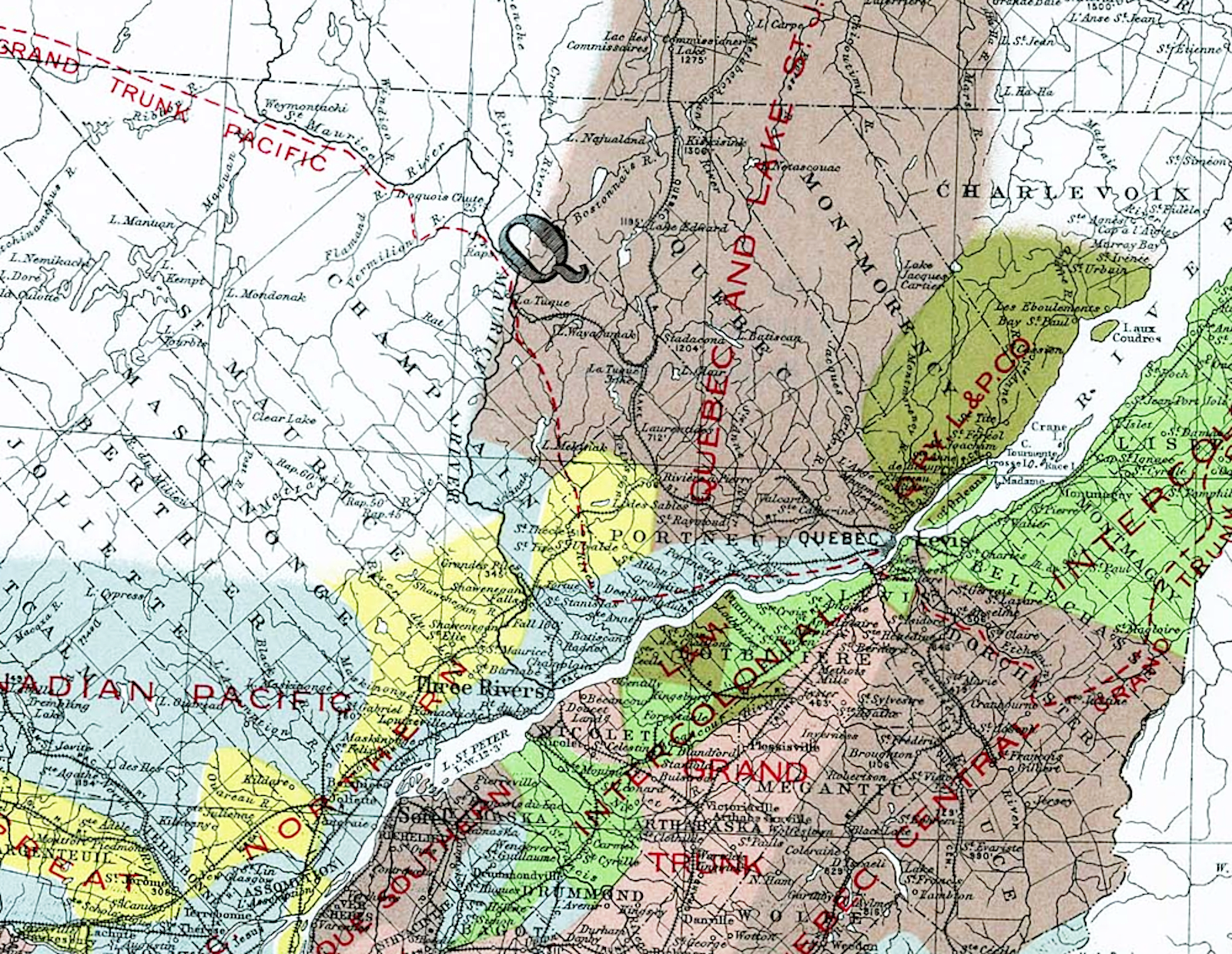
On the government railway map from 1906 below, you will recognize some names of railways which became part of Mackenzie and Mann's eastern Canadian Northern Railway network. If you spot the red Quebec & Lake St John label ... the original settlement of Valcartier can be seen to the right of the red letter 'Q'.

from: Atlas of Canada; 1906; Government of Canada. natural-resources.canada.ca 

*  *  *

Here is the profile of the Quebec & Lake St John railway and you can see that Valcartier is about 17 miles from Quebec City. 

from: Bibliothèque et Archives nationales du Québec

*  *  *

The two linked postcards ...


There was a large circus-size tent which housed a drop-in and support centre - signed as a 'chez nous' for soldiers at Camp Valcartier. These two postcards to Ontario - one for Port Dalhousie and one for St Catharines - were probably obtained there. Virtually all of the thousands of soldiers here were housed in those bell tents shown above. There were few permanent buildings at Valcartier and you can often see farm houses and barns in the distance.

The wartime departure dates of solitary fast troop transports, and convoys, were kept as secret as possible as the U-boat menace developed. This first large wartime convoy of World War One seems to have been less of a secret. 

The large movement of soldiers and ships - escorted by British warships - probably overwhelmed the organizational readiness of both the German U-boat fleet and the Canadian officers and chaplains responsible for censoring mail.

*  *  *


The addressee is rotated 180 degrees and reproduced below so you can read it more easily.


*  *  *


from: The World War, Vol 1; Holland Thompson; 1921; Grolier Society.

This painting looks more impressive in full colour, but I wanted to include this century-old description.
Accounts state that this was the largest convoy of ships to ever across the Atlantic, up to this point.
Harold Wolhaupter would have been on one of these ships.

from: The World War, Vol 1; Holland Thompson; 1921; Grolier Society.

And Harold Wolhaupter would have spent about 4 months camped out on this plain. It was one of the rainiest winters on record. Epidemics of diseases such as diptheria and meningitis made the rounds of the soldiers living in tents, pitched in the standing water on the poorly-drained fields.

Across the Channel, the early 'war of movement' was bogging down. After the Germans failed to take Paris, they made tactical retreats to nearby high ground and dug in. The stalemated trench war began. 

Initially, those commanding the armies of the British Empire didn't know quite what to do with the troops from the dominions and colonies. Training in the rapidly-evolving tactics of trench warfare seemed to be a good investment ... at least until the necessary deployment decisions could be made. 

... Differences of strategy between the British and their French allies often made things complicated.


from: The World War, Vol 1; Holland Thompson; 1921; Grolier Society.

Notice how young they are.

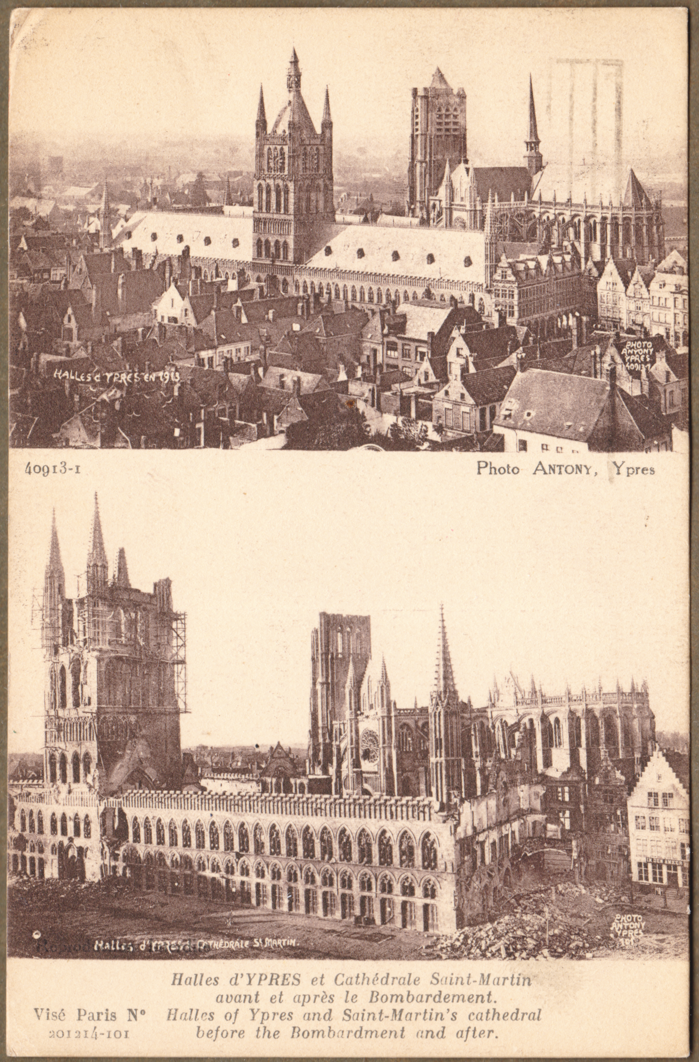
Trenches were used, because they saved lives. With the potent weapons of modern industrialized warfare ... like the machine gun, quick-loading field guns, and howitzers, the soldiers had to be below ground level just to survive. However, trenches provided no protection from poison gases - such as the heavier-than-air chlorine gas which the Canadians experienced at the Second Battle of Ypres in early 1915.

*  *  *

Meanwhile, recruiting efforts had already been underway for the Second Contingent of the Canadian Expeditionary Force ...

from: Canadian War Posters; Marc H Choko; 2012; Worth Press.

The war dragged on. Extensive barbed wire entanglements placed in front of the trenches funneled enemy attackers into paths through the wire which were well-targeted by machine gun emplacements. Artillery barrages directed at the other side's elaborate trench networks took a steady toll on those rotating forward to occupy the front-line trenches, those occupying the front-line and those rotating back to rest areas. 

Fatigue parties were kept busy with activities like resupplying the front line with food and ammunition, reinforcing parapets, dugouts ('artillery bomb shelters') and trenches ... and working on the barbed wire entanglements by night. 

Telegraph and telephone network wires were in constant need of repair by specialists as wires were broken by artillery fire. Runners (including one named Adolf Hitler on the other side) filled in gaps in the communication systems ... ensuring that the commanders at the rear could send orders all the way to those in the front trenches.

From time to time the enemy's trenches would be seized in an attack. A hasty engineering effort then had to be made to build a defensive parapet and firing step to protect against an immediate counter-attack. The enemy trenches and territory 'won' and held would contain water, mud, corpses, bodies torn apart by artillery, shallow improvised graveyards and the ever-present well-nourished battlefield rats.


from: Canadian War Posters; Marc H Choko; 2012; Worth Press.


*  *  *

Harold Wolhaupter in France in 1917

The map below shows the status of part of the Western Front, two-and-a-half years after Harold Wolhaupter left Valcartier.

The map shows the front lines in the days immediately after Canada's 'coming of age as a nation' at Vimy Ridge.

Harold Wolhaupter will be going into battle at Fresnoy.

from: Official History of the Canadian Army in the First World War; Col GWL Nicholson; 1962; Minister of National Defence.

*  *  *

A German soldier's memoir of World War One includes this typical description of the artillery barrages
in the days before the Canadian advance to take the little town of Fresnoy and the area around it.

from: Storm of Steel; Ernst Jünger; 1920,1961; Penguin.

*  *  *

The Canadian advance on Fresnoy.

from: Official History of the Canadian Army in the First World War; Col GWL Nicholson; 1962; Minister of National Defence.

[The account discusses Lieutenant Combe. In this paragraph, it should read 'enemy' grenades (not 'energy' grenades). The scanning and proofing of a hard-copy book into electronic form would be a long and tedious process.]

from: Official History of the Canadian Army in the First World War; Col GWL Nicholson; 1962; Minister of National Defence.

Above, is the account of the events on 3 May 1917.

Below, is the account of the Germans' recapturing of what was left of Fresnoy on 5 May 1917.

from: Official History of the Canadian Army in the First World War; Col GWL Nicholson; 1962; Minister of National Defence.


*  *  *


Sergeant Harold Phillip Wolhaupter (age 22) of the Canadian Infantry, Central Ontario Regiment 
was killed during the first day of the battle at Fresnoy, 3 May 1917. 
His name is recorded on the Vimy Memorial.

He was the only son of Mary Adelaide Wolhaupter, of 9 Salina St, St Catharines, Ontario, 
and the late George B. Wolhaupter. (source veterans.gc.ca).

"Inscribed on the ramparts of the Vimy Memorial are the names of over 11,000 Canadian soldiers 
who were posted as 'missing, presumed dead' in France."


from: Books of Remembrance, Peace Tower.
veterans.gc.ca