Below you can see the former station at Marathon - at roughly the half-way mark of the Heron Bay subdivision.
The most scenic and impressive part of the CPR line between White River and Thunder Bay (in my opinion) will be covered in this post.
From Marathon, Eric's photos will take us west to Schreiber.
If you wish, clicking on the link below will open an employee timetable in a new tab.
Below is a quick overview of the area. The yellow line marks the route of the Trans-Canada Highway. Completed in the 1960s, it benefitted from modern surveying, blasting, and earth- and rock-moving technology. The high adhesion between rubber tires and asphalt allows for the inclusion of some impressive grades in both directions. This modern through-route was not completed until the 1960s.
In 1885 - when this railway line was completed - aerial surveys of the land were not possible. Over 7 million dollars (perhaps $200-400 million in today's dollars) worth of black powder, nitroglycerin and dynamite were used for blasting in this section. The most powerful equipment for moving rock and earth was powered by horses or small steam engines - often operating on narrow gauge tramways laid into the rock cuts.
Out of necessity ... as explained in Heron Bay, Part 1 ... much of the CPR main line was laid close to the shore.
Even with the modern technology of the 1960s, the yellow line of the Trans-Canada Highway meanders as it joins small settlements. For most of its route, you'll notice that the CPR is between the highway and Lake Superior.
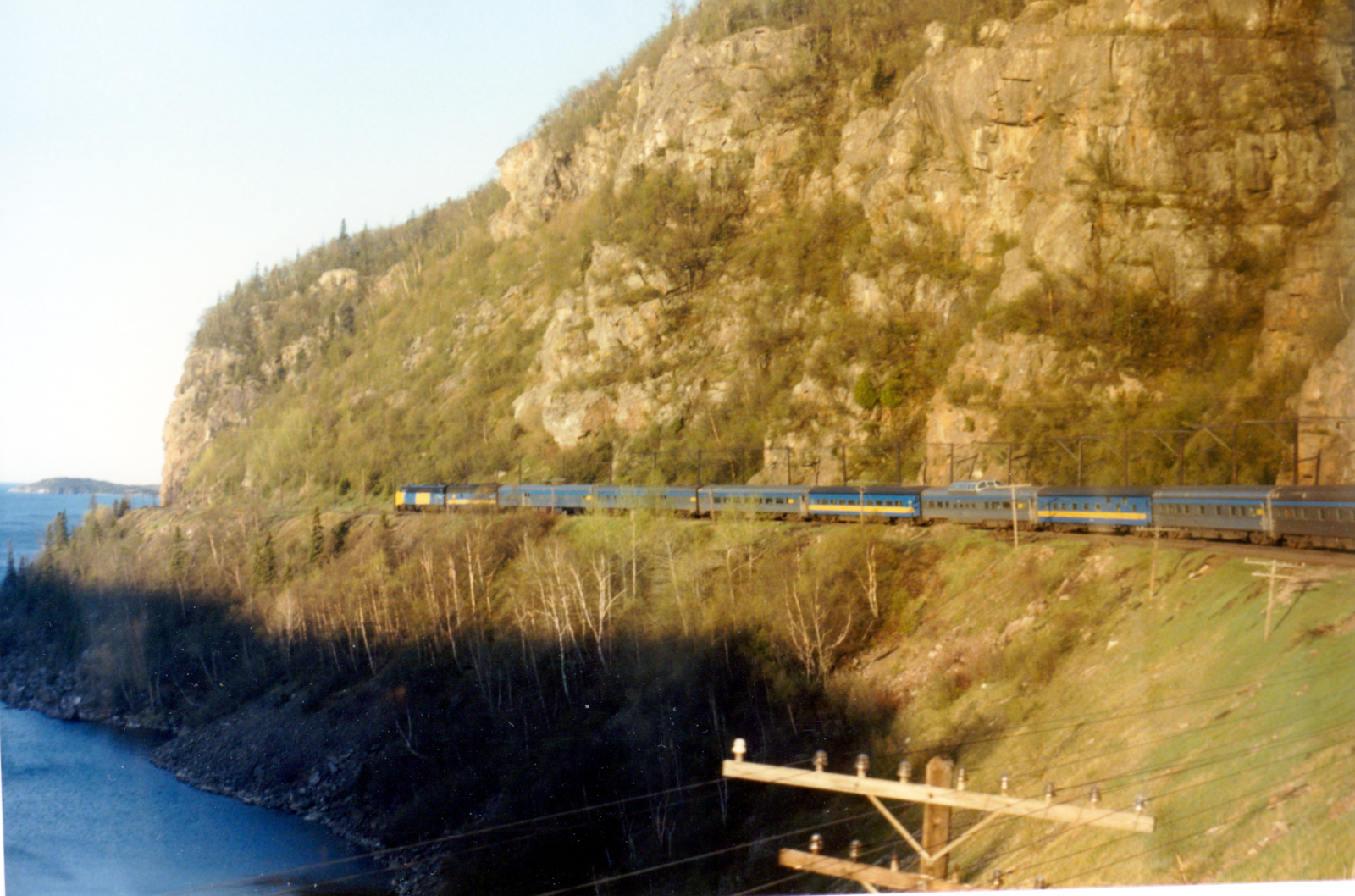 |
| Near Mile 72. |
It turns out that both Eric and I take pride in ensuring that our blogged images are as straight and level as possible ...
If you have ever tried to 'level' a photo (including postcard photos) by using a curving railway line or a curving distant shore line as a horizon - you know what frustration is (see my effort above).
Furthermore, while metal CTC signal poles are usually quite plumb (assuming the convexity of the camera lens is not skewing them at the edge of the photo) ... there are very few telegraph/code-line poles in all of Canada which are plumb. Probably zero.
What a gift it is to be provided with a clear stretch of horizon on a great inland sea! ...
 |
| Near Mile 72. |
 |
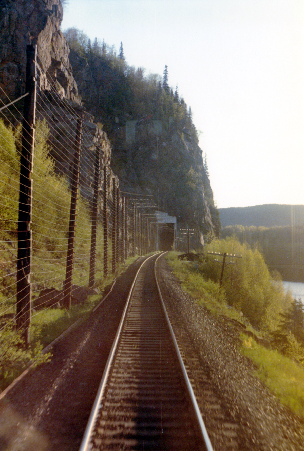
| Red Sucker Tunnel, mile 72. |
You can see the closely-spaced Rock Fall and Slide Detector wires protecting the side and top of the right of way.
I have left the sky a little on the pink side to resolve all the overhead wires.
 |
| Red Sucker tunnel Mile 72. |
 |
| Mink Tunnel Mile 73. |
 |
| Mink Tunnel Mile 73. |
Mink Tunnel has been the subject of many postcard photos since the opening of the CPR.
 |
| East switch Coldwell, Mile 74.7 . |
Port Coldwell is such a beautiful spot that the Scottish engineer who was responsible for that rock cut and the roadbed in this area - RG Coldwell - asked his Scottish family to arrange for his burial in Port Coldwell's graveyard. The graveyard is easily accessible from the Trans-Canada and his place is marked by a tall granite column. Just beyond the trees, on the far side of Echo Lake, is Lake Superior.
 |
| Coldwell, Mile 74.7 . Eastbound 0715hr, Eng 6013 5001 [SD, unknown] 4743. |
With No 1 moving through the passing track, the engineer on the eastbound freight indicates he spotted no defects on No 1.
Photo captions linked to sidings use the official siding mileage, not the actual mileage location of the photo.
 |
Coldwell, Mile 74.7 . Eastbound 0715hr, Eng 6013 5001 [SD, unknown] 4743.
|
 |
Coldwell, Mile 74.7 .
The backtrack marks the site of Port Coldwell.
The graveyard and the former port are reached by following the road down the hill, to the right. |
Above: The Google view includes three of the features you've just seen at track level. Starting at the right (timetable east) side of the image:
- The concrete-lined Red Sucker Tunnel provides a green cover over the right of way.
- Mink Tunnel is on the west end of that sharp left-hand curve. Both tunnels are bored through rock buttressing the masses of rock above them. Without these 'buttressing' tunnels, a much larger removal of rock would have been required at the two locations. Perhaps this is due to the natural path of water through the rock formations, and the instability which would be brought on by erosion and freeze-thaw cycles during the year.
- The elongated trackside lake is Echo Lake. You can see the dirt road leading from the Trans-Canada to the site of the former town and port of Port Coldwell.
On the topographic map below, the same features are show between my markings of Mile 71.5 to Mile 74.5 .
The westbound ruling grade on the Heron Bay subdivision occurs between Mile 74.5 and Mile 77.5 .
The eastbound ruling grade is between Mile 81 and Mile 77.5 .
Inconveniently, the bridge at Mile 81 has a permanent 30 mph slow order.
 |
| Bridge Mile 81, Little Pic River. |
Something which feels as if it happened with some regularity on my eastbound trips was the engineer getting up and giving me a quick orientation to key switches and buttons on the back wall of the locomotive cab (the old deadman's pedals always seemed to 'stick' to the floor, somehow). As we approached the ruling grade, sometime after passing Middleton siding, the spareboard headend trainman was sent back to get what support could be obtained from a trailing isolated unit ... by turning the Isolation Switch on the Engine Control Panel, sometimes along with other specific actions. I have no recollection whether these efforts ever resulted in the hoped-for extra power to conquer the ruling grade.
You exited the engineer's door because it opened to the rear. So ... you had a nice view of the countryside and lake to the 'south side' during the trip back over the running boards of one or more units.
Generally, you'd enter the trainman's door on the north side of a unit, cross the cab and exit the engineer's door on the south (or vice versa, if the unit's cab was facing the rear of the train) as you made your way back. It was important to watch for ice or snow underfoot.
The units would sway, so one kept the back or shoulder of one's winter coat in general contact with the oil and dirt-covered engine access doors along the running board as one slid one's left hand along the handrail (while heading toward the rear units). This quickly gave the green trainman's coat that 'seasoned railroader's look'. The obvious concern was an unanticipated lateral lurch sending you off the side of the unit.
However, from an actuarial standpoint, stepping over the gap between two swaying units probably offered a much higher probability of coming to grief. The units often swayed in opposite directions and the fold-down steps at running board level over the unit ends were not always down to provide drawbridges between them. The side safety chains - strung a waist level between the two units' steel handrails - were not always in place, or even present, and (perhaps inaccurately and unfairly) I remember them having the gauge and heft of chains used in children's swing sets. The chains were probably there to help prevent one from falling sideways between the ends of the coupled locomotives and being ground up under the following unit - but one was wise to trust only the solid steel handrails when moving between the connected units.
Eventually, you reached and entered the cab of the appropriate unit, fiddled with the controls, and generally were quite impressed with the sudden roar and vibration you were able to produce through your trivial efforts after only 30 seconds of in-service training.
If everything was timed right ... the engine you had put back 'on line' would be running as the power was crossing this bridge, so maximum power would be available to climb the ruling grade on the other side.
Furthermore, if everything was timed right ... you were safely back on the running board of the lead unit as it crossed the bridge and, as a reward, you could pause there for a few seconds and just enjoy the view.
Here is a Google view of the Little Pic River bridge with the ruling grade and uphill curvature to the left.
The elevations are exaggerated but you can imagine riding on the running board of a roaring engine as it crossed the bridge ...
with the river below and only a single handrail between you and that vast expanse of space and scenery
- the view virtually unchanged since the beginning of the railway.
Here is a really nice photo which Eric took of the whole bridge.
 |
| Bridge Mile 81, Little Pic River. |

Above and below: You can see a Google view above, and a 1970s top map below ...
covering the eastbound and westbound ruling grades.
Eastbound, the ruling grade rises from the bridge at Mile 81.0 .
Westbound, the ruling grade rises from Mile 74.5 .
The summit in both cases is near the western tip of Neys Lake at Mile 77.5 .
* * *
At the Summit of the Ruling Grades, Looking East
One could also have adventures going eastbound down the other side of the ruling grade. Above, you can see the track at the right margin of the image as it passes the west end of Neys Lake - which is almost at the summit in both directions. The track will descend eastbound until it almost reaches lake level at Mile 74.5 (basically, the Coldwell backtrack).
Although the elevations are exaggerated, you can see the line curving back and forth as it avoids obstacles and as it lengthens its distance to descend at a more gentle rate - but it is still steep enough to be the ruling grade for westbounds.
One fine day, we were on an eastbound freight descending the (westbound) ruling grade toward the home signal at Coldwell siding and the engineer and I called 'Stop' to each other. I didn't quite realize the seriousness of the situation, but there was a flurry of activity on the right side of the cab and the train was probably put into emergency. We passed the stop signal - which is a very serious violation of the rules because it could result in a collision.
The engineer quickly had the dispatcher on the radio, stated our location and situation, and said that the signal had been 'thrown in our face'. Normally, the intermediate signals would have given ample warning to the engineer to slow the train gradually and safely, as we descended the steep hill so a controlled stop could be made if we were to encounter another train at Coldwell. Throwing a train into emergency application of the brakes can sometimes result in a derailment, particularly if there is harsh slack action among the cars in the consist.
... I worked when vans (cabooses) and 4-person crews were still the standard. At sidings, the two trainmen were theoretically supposed to perform pull-by inspections of their trains. The headend trainman was to drop off at the middle of the siding to watch his headend half pull by, then walk and inspect the opposite side of the train as he returned to the engine. Once the train was stopped, the tailend trainman was to walk up to the halfway point as he inspected, cross over, and do a pull-by inspection as the train left the siding. There were no hotbox detectors on the Heron Bay subdivision back then.
Authorizations were taken at call boxes located at the sidings' absolute signals - never over the radio. Because of the VHF signal blocking by the old, weathered mountains, train to wayside radio communication was still really spotty on the Heron Bay subdivision. The vans still carried telephone sets to connect with the trackside telephone wire in emergencies.
... I was seeing the end of traditional Canadian wilderness railroading.
Back at Coldwell, having just run through the stop signal ... had we been without immediate radio contact with the dispatcher, the engineer would have communicated the emergency via the telephone call box, while I would have run the prescribed distance down the track ahead with a flagging kit to protect the headend of the train ... in compliance with the rules. (While the automatic block protection of the CTC might be assumed to protect our headend - that might be a bad assumption on a day when multiple little bad assumptions were being made by others at very the same time. Better to be caught running to flag than making snow angels.)
Later on, I learned that Trainmasters were the field supervisors for train crews and that they were to perform a given number of Efficiency Tests every month. Essentially, realistic 'situations' were created by the Trainmaster, and the reactions of the crew members were observed by the Trainmaster to ensure that the rules were complied with. Eventually, they got radar guns too.
In recent years, it occurred to me that while this event at Coldwell could have been caused by a dropped block or another simple bug in the signal system ... it would have made a good Efficiency Test. Keeping the train under good control down the grade, an immediate appropriate response upon first seeing the stop signal, and the immediate reporting to the dispatcher of our passing an absolute signal displaying 'stop' ... being the procedures under test.
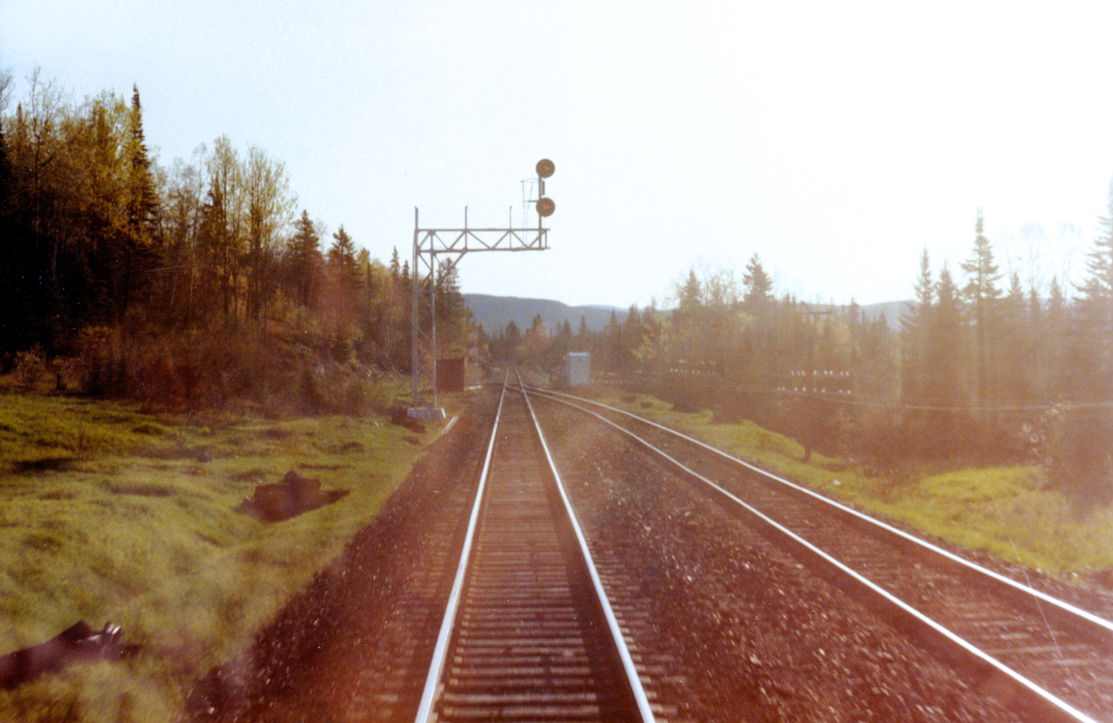 |
| East switch Steel, Mile 92.0 . |
Above, at Steel, you can see the instrument case which includes a white call light (the dispatcher wants to talk to you) and a dispatcher call box.
 |
| Bridge Mile 95, Steel River. |
 |
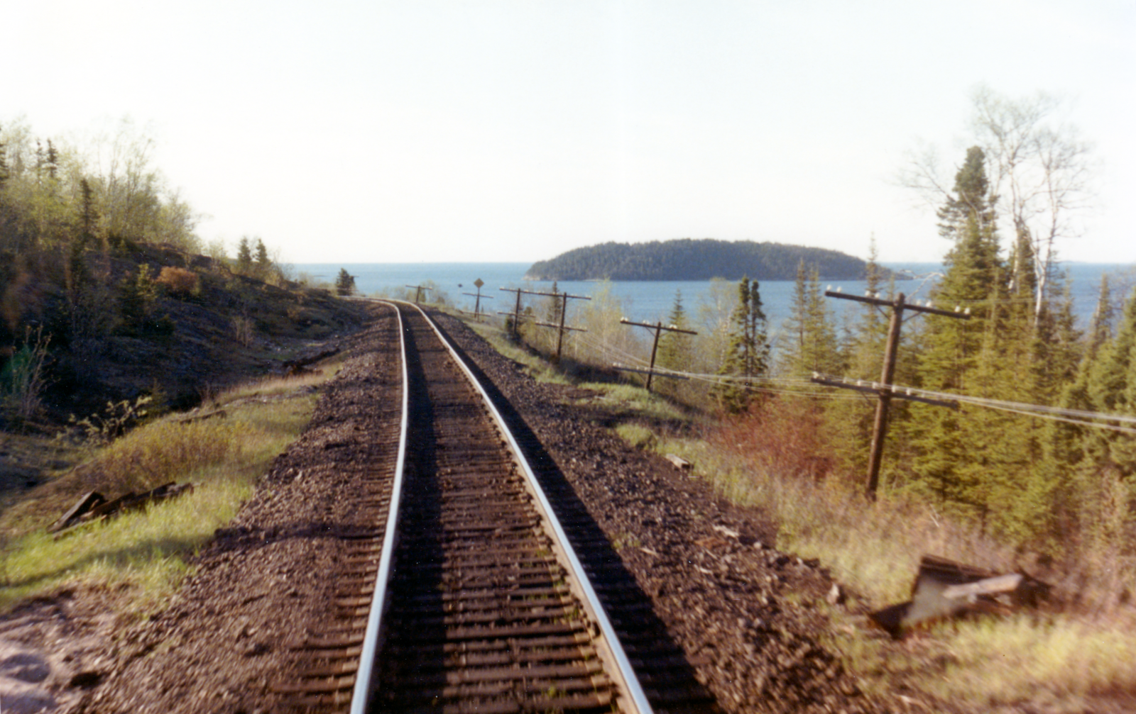
| Possibly: Slate Islands - seen near Steel. |
The trip around Tunnel Bay impressed you with how small the railway was compared to this land feature. Jackfish was developed as a railway harbour for the purpose of importing American coal for use in steam locomotives.
 |
| East switch Jackfish Mile 98.2 . |
 |
| Boarding cars on the back track, Jackfish Mile 98.2 . |
The 'New Yards' were located here to the north of the current siding
and stockpiles of coal for winter use by steam locomotives across the Division were stored on this cleared plain.
 |
| Slow order at Mile 100. |
 |
| Jackfish Tunnel, Mile 102. |
In the Google view above you can see the location of the current siding and the former 'New Yards' at the right ... and the overland trail from there - which led to the town and the coal port. At the top left of the enlargement below, you can see the underwater remnants of the long concrete coal unloading pier at at a 'ten o'clock' angle. At the bottom right are the remains of the dynamited 'new' concrete coaling tower (white, at the left of the track) which replaced an earlier one made of wood.
 |
| Mile 103.7 . |
Above, you can see Moberley Bay to the west of Tunnel Bay. Westbound, it was a tradition for the headend to call 'OK around the bay' with the tailend acknowledging the call. There was often an almost unobstructed view of one's entire train here. At night, one could have seen sparks or flames ... but the distance made a true inspection impossible. On occasion, the engineer would cross to my side to admire his train in its entirety. The PAT train (something like: Pacific Auto Transport) provided a nice sight in the early morning light.
But the thing about Moberley Bay was that it smelled like the worst sulphurous mill waste you've ever encountered. On the coldest winter day the stink hammered its way in to saturate the cab. I have no idea if conditions are still the same today.
While an broad open trench of fragrant hot liquid waste crossed under the highway east of Terrace Bay, I could never figure out how the smell got way over to Moberley Bay ... until I was studying the maps for this post.
- Starting at the Terrace Bay mill, you can see 'Trans Sta' at the top right of the plant.
- A blue trench runs northeast into Blackbird Creek.
- It runs into Lake A, labelled as Mill Waste.
- North of Lake A, it continues its flow along Blackbird Creek.
- Blackbird Creek runs into Moberley Lake.
- Moberley Lake flows into Moberley Bay ... right under our noses.
 |
| East switch Terrace Bay, Mile 109.9 . |
 |
Terrace Bay, Mile 109.9 .
|
Eric is facing some very difficult photography conditions here. He's shooting almost directly into the sun and the main features being recorded are in shadow. I don't know how the photofinishing of the 1980s, pigment changes and time have affected the primarily maroon tint of some of these 4x6 inch prints.
It is still really nice to have them because many of these features have disappeared and I've tried to bring out as much historical detail as I can.
Above and below you can see the long-departed station at Terrace Bay. The setoff yard for the plant switcher is seen to the left. During a trial trip, I was placed on the afternoon/evening Schreiber yard switcher. The power was an S-3 and our van was an old wooden end-cupola with no interior lights except for our battery lanterns. Kerosene markers were lit for the shuttle between Schreiber and Terrace Bay and back.
 |
| Bridge Mile 110.5, Aguasabon River. |
 |
| East switch Schreiber, Mile 118.3 . |
 |
| East switch Schreiber, Mile 118.3 . Eastbound Eng 4559 4708 4730, 10 cars. |
 |
| Schreiber, Mile 118.3 . |
 |
| Schreiber, Mile 118.3 . |
Departing Schreiber for the Nipigon subdivision.
You can see evidence that the steam generator water of No 1's power has been topped up.
Finally, here is a circa 2020 Google view of Schreiber, showing the eastern approach over the last miles of the Heron Bay subdivision.


